
United Reformed Church in Abergavenny
United Reformed Church in Monmouthshire, Abergavenny is a church. It is near Castle Street and is also known as Abergavenny United Reformed Church. The church is a listed building.
- Amenity
- place of worship
- Building Type
- building
Image
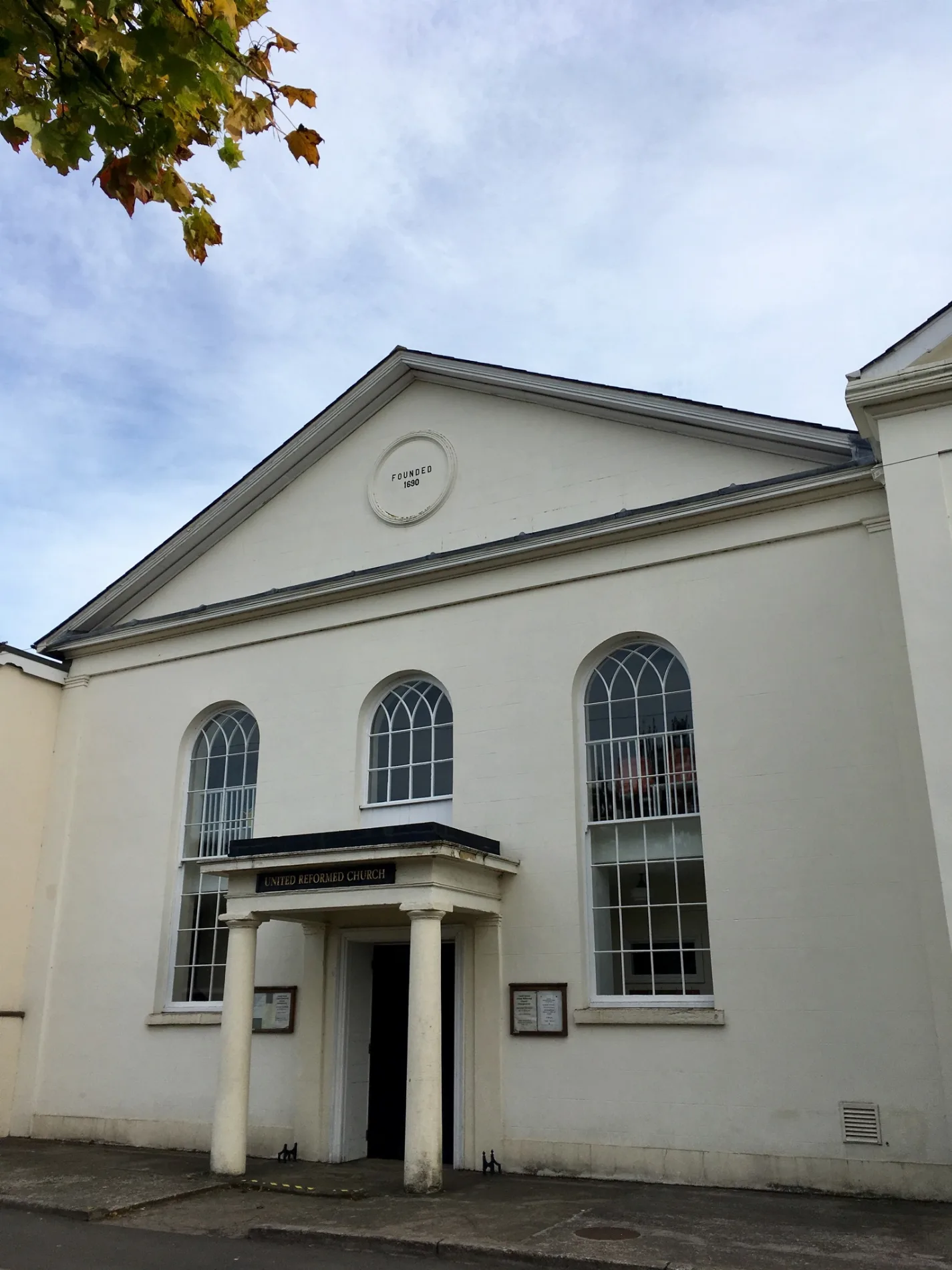
Pubs
Chemist's
Restaurants
Health food shops
Community centre
Clothing shops
Bank
Shoe shops
Police stations
Charity shops
Cafés
Art galleries
Pharmacy
Gift shops
Opticians
Roads nearby
Castle Street50 m
Lower Castle StreetAmanda Jane, The Angel
100 m
Flannel StreetNeil Powell, Hen & Chickens, Grape Tree, Parsons
100 m
Plantagenet Close100 m
St John's Street100 m
High StreetJohnsons, The Gaff, Bonmarché, Greggs, Nationwide, Blue Cross, Boots, Fat Face, Costa, Santander
150 m
St. John's LaneCooks Galley
150 m
Nevill StreetRate of Rise Coffee Roastery, Get Together, Tredors, Sue Ryder, Madame Fromage, Get Connected, Parrys, The Make House, Gurkha Corner Restaurant, H. Shackleton, Mountain Warehouse
150 m
Market StreetThe Vaults, Borough Theatre, The Gaff, Bean & Bread, Abergavenny Community Hub, Gateway Credit Union Abergavenny, Abergavenny Library
200 m
Cross StreetAbergavenny B&B, AF Thomas, Cinnamon Tree, Abergavenny Music, Computer Centre, The Teddy Bear Shop, Head Room, Marmaris, Dynamite Branding, Magnolia, Coffee Shop, Coach & Horses, Tamarind, Town Gate Takeaway, Balti Delight, Pick A Pizza, Premier, Hilary's Floral Design, Sing Lee Chinese Takeaway, Monmouthshire Citizens Advice, Sigma 3 Kitchens, GFA Fulgoni, Abergavenny Bargain Centre, The Gateway, Greco, Kings Head Hotel, Abergavenny Police Station, Alison Tod Milliner, Rosemary, Cafe Luigis, Style Boutique, The Art Shop, Revue, Greyhound Rescue Wales, Savers, Halifax, British Heart Foundation, Regency, Cwtch Cafe, St. Davids Hospice Care, Cariad, Lloyds Bank, Alison Todd
200 m
Beili PrioryTithe Barn Café
200 m
Monk StreetPavilion, Angel Bakery
200 m
Horsington Yard250 m
Lion StreetCaffè Nero, The Vape Escape, Head Quarters, The Strand, Country Brides, Harrhy Carpets & Beds, base, K&J Crafts
250 m
Frogmore StreetMiles Morgan Travel, Vodafone, Marie Curie, Vision Express, Extons, Clarks, Ladbrokes, Mezze Me, Tapas Twist, Ladies Emporium, Il Gusto
250 m
Mill StreetMotorcare, BW Auto Services, Screwfix, Worcester Electrical Distibutors, Gwent Garden Designs, Abergavenny Museum
300 m
Amenities nearby
Shopmobility100 m
Apartment buildings nearby
Plas Elyrch250 m
Buildings nearby
Gateway Church Rehoboth Centre50 m
Abergavenny Post Office100 m
Lodge150 m
Swan Offices200 m
NFU Mutual250 m
Cafés nearby
Portico Lounge250 m
The Chapel250 m
Oasis Sandwich Bar300 m
Car repair shops nearby
JP Tod Commercials400 m
Abergavenny Auto Repairers400 m
Funeral directors nearby
Abergavenny Funeralcare50 m
Ice cream parlours nearby
Shepherd's Ice Cream200 m
Industrial areas nearby
Mill Street Ind. Est.500 m
Marketplaces nearby
Abergavenny Market150 m
Orchards nearby
Community Orchard350 m
Parks nearby
Abergavenny Castle250 m
Places of worship nearby
Methodist Church50 m
Post depots nearby
Abergavenny Delivery Office100 m
Pubs nearby
Wetherspoon The Coliseum250 m
Residential areas nearby
Vine Cottages, Baker Street250 m
Restaurants nearby
Kong's200 m
Retail buildings nearby
Neil Powell100 m
jacobi150 m
Fig Tree Garden200 m
Rivers nearby
Afon Gafenni500 m
Specialist shops nearby
Heronhurst350 m
Mirage400 m
Streams nearby
Afon Cibi450 m
Supermarkets nearby
Aldi300 m
Tourist information offices nearby
Wellbeing Information Centre250 m
Wine shops nearby
Chester's Wine250 m
| Elevation | 63 m |
|---|---|
| Heritage designation | Grade II listed building, National Monument of Wales |
| Located in | Abergavenny |
| Postal code | NP7 5EN |
| Country | United Kingdom |
| Location | Abergavenny |
 Public transport map Abergavenny Legend
| Railway | |
| Bus | |
| Tram |
 Cycling map Abergavenny Legend
| Cycle path | |
| Cycle lane on road | |
| Cycling on bus lane | |
| Bicycle street | |
| Cyclists allowed | |
| Cyclists allowed, good surface | |
| No cycling | |
| Cobblestones |
| Long-distance cycle route | (depending on scale) | |
| Long-distance cycle route |
 Walking map Abergavenny Legend
| Path |
| Long-distance hiking trail | (depending on scale) | |
| Long-distance hiking trail | ||
| No pedestrians |