
Milton Terrace in Miltonsfields
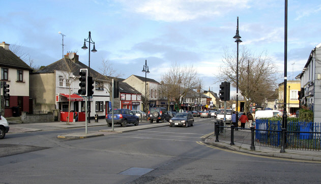
Milton Terrace in Miltonsfields is a two-lane, asphalted secondary road (50 km/h, road number R836). The condition of the road surface is good. It runs in a northeast-southwest direction and ends at Dublin Road, while the other end is a cul-de-sac. In the vicinity, you can find among other things a fast food restaurant, a charity shop, a tattoo studio and a charging station.
- Road Type
- secondary road
- Speed Limit
- 50
- Lanes
- 2
- Route
- northeast-southwest
Image
Fast food restaurants
Tattoo studios
Car repair shops
Roads nearby
Main StreetWorkwear Boot Store, Laundrette, Lāčplēsis, Two for Joy
100 m
Well RoadColour Trend, St Colmcilles Well, Saint Colmcille's Well, The Old Borough Hotel
250 m
Swords Central MallSwords Post Office, Subway, More For Less, Boston Belle, Intersport Elverys, Style Club, fone Connection, Dealz, Specsavers, The Works, Starbucks, Ecco, Penneys
300 m
Forster WayPolonez, Pet republic, The Music Outlet, Protocol, Vanity X Makeup Academy, Plaza Leisure, Dublin North City and County CAMHS, Smiles
350 m
The GutMcDonald's, Antonia Lehan Surgery, June Rutland Hair Salon, Acme Blinds, Biofresh Skincare and Makeup, Ultimate Styling Barbers
350 m
Malahide RoadWright's Café Bar, Apache Pizza, Tirconaill B&B
350 m
Church Road350 m
The PlazaThe Plaza, Turkish Barber, Swords Eye Centre, Dowling Jewellers
350 m
The Plaza Crescent400 m
Saint Colmcille's CourtEuroGiant
400 m
Town Centre MallIndie Spice, Richies Bike Store, Karma Tattoo, The Cottage, Studio M, Pink Beauty Clinic
450 m
RivermallD'Chilli Shaker, Macnamara's Pharmacy, EBS, Diva Hair and Beauty, Green Straw, Seven Swords
500 m
Shops nearby
Maria C Design450 m
Apartment buildings nearby
Cooldriona Court200 m
Banks nearby
Members First Credit Union400 m
Bars nearby
The Chalk Venue300 m
Beauty salons nearby
Glam Beauty450 m
Beverage stores nearby
Oakberry Acai450 m
Bicycle shops nearby
Ritchie's Bike Store450 m
Bookmakers nearby
Paddypower450 m
Buildings nearby
Golden Tree350 m
ThermoGlaze450 m
Constructions nearby
Lord Mayors SHD100 m
Container buildings nearby
Breast Check200 m
Dental practices nearby
Vivian Mongey450 m
E-cigarette shops nearby
Vape Escape400 m
Electronics shops nearby
Repairs450 m
Fast food restaurants nearby
Mizzoni Pizza & Pasta Co400 m
Hairdresser's nearby
HairMaster450 m
The Turkish Barber450 m
The Mall Barber450 m
Peter Marks500 m
Hardware shops nearby
Crown Decorating Centre450 m
Hotels nearby
The Forty Four450 m
Office buildings nearby
Hibernian Estates400 m
Adult Education Service400 m
North Dublin Regional Drug Taskforce450 m
Pet shops nearby
Pet Republic450 m
Police stations nearby
Swords Garda Station300 m
Public buildings nearby
Swords Social Welfare Exchange300 m
Pubs nearby
The Old Borough300 m
The Old Schoolhouse300 m
Retail areas nearby
Swords Pavilions Shopping Centre250 m
Swords Central Shopping Centre300 m
Retail buildings nearby
s400 m
The Laser Studio450 m
School buildings nearby
The Old Borough National School400 m
Supermarkets nearby
Umami300 m
Tattoo studios nearby
Ludicum Art450 m
Public transport map Miltonsfields Legend
| Railway | |
| Bus | |
| Tram |
Cycling map Miltonsfields Legend
| Cycle path | |
| Cycle lane on road | |
| Cycling on bus lane | |
| Bicycle street | |
| Cyclists allowed | |
| Cyclists allowed, good surface | |
| No cycling | |
| Cobblestones |
| Long-distance cycle route | (depending on scale) | |
| Long-distance cycle route |
Walking map Miltonsfields Legend
| Path |
| Long-distance hiking trail | (depending on scale) | |
| Long-distance hiking trail | ||
| No pedestrians |