
Castle Forbes in Aberdeenshire
Castle Forbes in Aberdeenshire is a castle. Castle Forbes is near Craigpot Suspension Footbridge. Ⓦ.
- Building Type
- castle
- Website
- https://www.castle-forbes.com/
Image
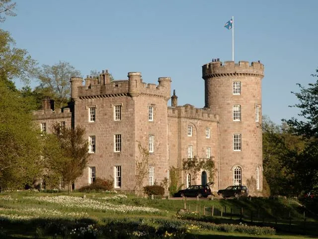
Roads nearby
Craigpot Suspension Footbridge700 m
Wealthyton Way1,4 km
The Lord's ThroatDonview
1,5 km
Woodland Wynd3,1 km
Gordon Way3,7 km
Granite Top / Cairn William Trail4,1 km
Omerta4,2 km
March Burn Descent4,3 km
Half Pint4,5 km
LTD4,5 km
Slippy Willy4,5 km
Pesky Karakumy4,6 km
Dalau Lama4,6 km
The Lang Stracht4,6 km
Pinball Wizard4,7 km
Macchiato4,7 km
Aberdeen RoadAberdeen Angus, Aberdeen Road, Huntly, Huntly Train Station Ticket Office, Mearns Academy, WDB, Laurencekirk Pet & Equine Supplies, The Co-operative Food, Cromar Court
4,8 km
Black Math4,9 km
Stewart Walk4,9 km
Stewart Crescent4,9 km
Main StreetRothienorman, Rothienorman Pre-school, Celebrations of Turriff, Nickel & Dime, Milanos, Cheynes Place, Chapel Lane, Costcutter, Main Street, Sandhaven, Sandhaven Post Office, School, Mitchell Court, The Terrace, Odyssee Hair Design, Johnshaven Stores, Knockhall Road, Inch Road, The Quay, Eider Road, Gardenstown, Longside, Station Road, Winding Brae, Market Hill, Bruce Brae, Longside Post Office, Cairnbulg, Cairnbulg Post Office, Aldersyde House, Banff Road, Cruden Bay Post Office & Store, Rhynie Post Office, MacKay Court, The Square, School Road, Priory Cottages, Sauchen, Green Meadows, The Arch Cafe & Bistro, Sir John S Forbes Memorial Fountain, New Deer Post Office, Culsh Terrace, S & N Purdie, Brucklay Arms, Church Crescent, Church Cresent, Luthermuir, Garmond, Bridge Gardens, Castle Road, Stewart Road, Great Wall, Kingsford Road, Alford Bistro, Alford, Everlong Art Studio & Gift Shop, Aberchirder, School Lane, Rose Innes Home
5,0 km
Jubilee Way5,1 km
Mortimers Way5,1 km
Badgers Box5,1 km
Castle RoadCastle Terrace, Balmoral Avenue, The Meadows Sports Complex, Ellon Castle, Deer Park, Cemetery Parking, Park & Ride Stance 1, Broomie's Cafe, Broomiesburn Road
5,1 km
Abandoned railways nearby
Alford Valley Railway4,3 km
Buildings nearby
Lickleyhead Castle4,6 km
Farmyards nearby
Elrick4,2 km
Towleys Farm4,3 km
Forests nearby
Slack Wood1,0 km
Priests' Wood2,7 km
Overton Wood4,1 km
Golf courses nearby
Alford Golf Club4,9 km
Houses nearby
Place of Tilliefoure3,8 km
Tilliefoure Steading3,9 km
Parkstyle3,9 km
Tillybrack4,0 km
Mains of Tilliefoure4,2 km
Mains of Tilliefoure Cottage4,3 km
Office buildings nearby
Reception4,4 km
Places of worship nearby
Keig Parish Church1,0 km
Public toilets nearby
WC, Shower4,5 km
Residential buildings nearby
Cornmill5,2 km
Streams nearby
Brindy Burn1,1 km
Corrie Burn1,1 km
Bents Burn2,8 km
March Burn4,0 km
Dalau Burn4,6 km
Woodlands nearby
Oak Brae4,3 km
| Heritage designation | category B listed building |
|---|---|
| Located in | Aberdeenshire, Keig |
| Country | United Kingdom |
 Public transport map Aberdeenshire Legend
| Railway | |
| Bus | |
| Tram |
 Cycling map Aberdeenshire Legend
| Cycle path | |
| Cycle lane on road | |
| Cycling on bus lane | |
| Bicycle street | |
| Cyclists allowed | |
| Cyclists allowed, good surface | |
| No cycling | |
| Cobblestones |
| Long-distance cycle route | (depending on scale) | |
| Long-distance cycle route |
 Walking map Aberdeenshire Legend
| Path |
| Long-distance hiking trail | (depending on scale) | |
| Long-distance hiking trail | ||
| No pedestrians |