
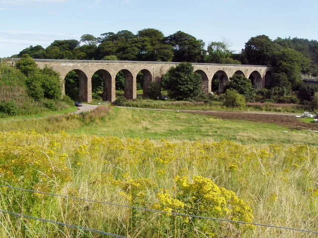
North Water Viaduct in Angus, Scotland
North Water Viaduct in Angus is an abandoned railway. It runs in a north-south direction and ends in a cul-de-sac. Ⓦ.
- Bicycle
- designated
- Road Type
- cycle path
- Route
- north-south
Image
Roads nearby
North Water Bridge150 m
Charleton RoadPeking Palace
1,2 km
Susan Carnegie Boulevard1,4 km
Orchard Way1,4 km
Houghton Drive1,5 km
Marykirk RoadMarykirk Road
1,6 km
Downie Way1,6 km
Pebble Dash1,6 km
Scott Crescent1,7 km
Dickson Avenue1,7 km
Sinclair Gardens1,7 km
Cruickshank Park1,8 km
Dalgarno Park1,9 km
Kinnaber Road1,9 km
Hospital RoadSunnyside Main Entrance, Hospital Road, Rosemount School
1,9 km
Gayfield Cottages1,9 km
Forties RoadAdult Resource Centre
2,0 km
Old School Way2,0 km
Loan DykesHillside Bridge
2,0 km
Dubton Road2,0 km
Rosemount RoadArbroath Infirmary, East Mains of Rosemount
2,1 km
Coronation AvenueBenmore Avenue, Coronation Avenue
2,1 km
Beaches nearby
Sands of St Cyrus1,9 km
Brownfields nearby
Sunnyside Royal Hospital1,6 km
Buildings nearby
Baker Hughes1,8 km
Petrofac1,9 km
GE Vetco Gray1,9 km
Montrose Rope & Sail2,0 km
John Lawrie2,1 km
Taylors2,1 km
Gemini2,1 km
Community centres nearby
Hillside Village Hall2,0 km
Farmyards nearby
Mains of Kinnaber650 m
Charleton Fruit Farm1,2 km
Forests nearby
Kinnaber Woods1,3 km
Greenhouses nearby
Summerhouse1,2 km
Industrial areas nearby
Hillside Distillery1,0 km
National Oilwell Varco2,0 km
Forties Road Industrial Estate2,0 km
Military buildings nearby
Old Listening Post900 m
Nature reserves nearby
St Cyrus National Nature Reserve1,7 km
Places of worship nearby
Dun and Hillside Parish Church2,0 km
Quarries nearby
Sand Quarry2,0 km
Railway lines nearby
Edinburgh to Aberdeen Line2,0 km
Razed railways nearby
Kinnaber Junction and Stanley Junction Line1,5 km
Residential areas nearby
North Esk Park450 m
Rivers nearby
River North Esk150 m
Service buildings nearby
Hillside Telephone Exchange2,0 km
Tourist information offices nearby
St Cyrus Visitor Centre2,0 km
| Located in | Aberdeenshire, St Cyrus |
|---|---|
| Country | United Kingdom |
| Crosses | River North Esk |
| Carries thoroughfare | Montrose and Bervie railway |
 Public transport map Angus Legend
| Railway | |
| Bus | |
| Tram |
 Cycling map Angus Legend
| Cycle path | |
| Cycle lane on road | |
| Cycling on bus lane | |
| Bicycle street | |
| Cyclists allowed | |
| Cyclists allowed, good surface | |
| No cycling | |
| Cobblestones |
| Long-distance cycle route | (depending on scale) | |
| Long-distance cycle route |
 Walking map Angus Legend
| Path |
| Long-distance hiking trail | (depending on scale) | |
| Long-distance hiking trail | ||
| No pedestrians |