
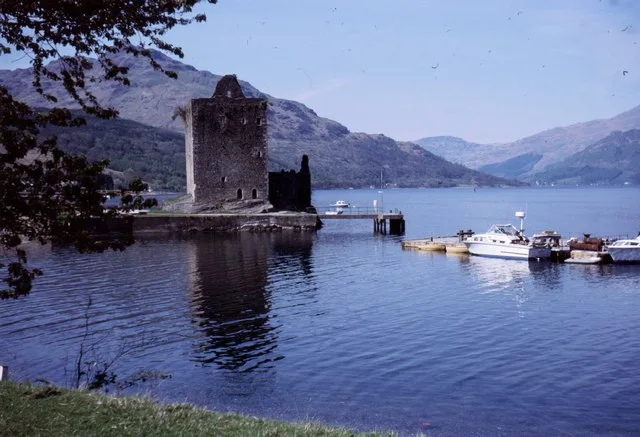
Carrick Castle in Argyll and Bute
Carrick Castle in Argyll and Bute is a castle. Carrick Castle is near Duke's Pass. Ⓦ.
- Building Type
- building
Image
Roads nearby
Duke's Pass4,0 km
Feuins Road4,0 km
Feorlin WaySpar
5,0 km
Smiddy Court5,0 km
Smiddy Road5,1 km
Whistlefield Road5,1 km
Linn Walk5,2 km
Mcauly Place5,2 km
Queen's Crescent5,3 km
Shore RoadThe Osborne, Sandy Beach, Dalriada Grove, Innellan, Shore Road at Mentone Place, Bowling Green, Blairmore, Blairmore Gallery, Strone, Pier, The Lido, Innellan Post Office, The Anchorage, Mambeg, Clynder, A T Hughes Lochside, Court Hill, Clynder Stores, Pier Road, The Soundings, Hunters Quay, Undercliff Bed & Breakfast, Carradale Harbour, Arinagour, An Acarsaid, Kilcreggan, Cove, Coulport, Letter, Cove Country Store, Kilcreggan Post Office, Ardpeaton, Gairletter, Café at Kilcreggan, Kilcreggan Antiques, The Creggans, Kilcreggan Garage & MOT Centre, Barremman, Rahane, Glengair
5,3 km
Clearways Lane5,5 km
Old School Road5,5 km
Hepburn Road5,6 km
Glencairn Park5,6 km
Upland Road5,7 km
Park Avenue5,7 km
Fairway5,7 km
Shore Walk5,7 km
Station RoadGarelochhead, Craigendoran, Cardross, Oban Station, Costa, Semichem, Café Shore
5,8 km
Dunivard Road5,8 km
Main RoadGarelochhead, Ali Fish & Chips & Curry Club, Cardross, Lomond Soap, Bloom & Beauty, Drinking Fountain
5,9 km
Body of waters nearby
Corran Lochan2,4 km
Lochan Ghlas Laoigh5,5 km
Buildings nearby
Lochwood House4,3 km
Trident Floating Dock5,1 km
Garelochhead Telephone Exchange5,4 km
Aldavhu5,4 km
Argyll House5,4 km
Glenald5,6 km
Elderberry5,6 km
Carloch5,7 km
Community centres nearby
Gibson Hall5,4 km
Farmyards nearby
Sligrachan Farm4,5 km
Houses nearby
Carrick Farm B&B200 m
Rock House5,7 km
Nature reserves nearby
Cormonachan Woodlands2,8 km
Railway lines nearby
Garelochead Viaduct5,2 km
Rivers nearby
Glen Finart Burn5,1 km
Service buildings nearby
Lochgoilhead Telephone Exchange5,1 km
Sports centres nearby
Ardroy Outdoor Education Centre5,7 km
Streams nearby
Allt Conbhach3,8 km
Allt Uamhach a' Bheithe4,0 km
McAuley Burn5,1 km
Dahlandhui Burn5,6 km
Allt an Uruisge5,7 km
Wilderness huts nearby
Mark Cottage3,6 km
Other nearby
Whistlefield Substation4,5 km
Whistlefield4,5 km
Trident Special Area5,6 km
| Floors above ground | 2 |
|---|---|
| Heritage designation | category A listed building, scheduled monument |
| Protected area | Loch Lomond and The Trossachs National Park |
| Located in | Argyll and Bute, Lochgoilhead and Kilmorich |
| Country | United Kingdom |
| Website | http://www.geo.ed.ac.uk/scotgaz/features/featurefirst4668.html |
| Described by source | CastlesFortsBattles |
 Public transport map Argyll and Bute Legend
| Railway | |
| Bus | |
| Tram |
 Cycling map Argyll and Bute Legend
| Cycle path | |
| Cycle lane on road | |
| Cycling on bus lane | |
| Bicycle street | |
| Cyclists allowed | |
| Cyclists allowed, good surface | |
| No cycling | |
| Cobblestones |
| Long-distance cycle route | (depending on scale) | |
| Long-distance cycle route |
 Walking map Argyll and Bute Legend
| Path |
| Long-distance hiking trail | (depending on scale) | |
| Long-distance hiking trail | ||
| No pedestrians |