
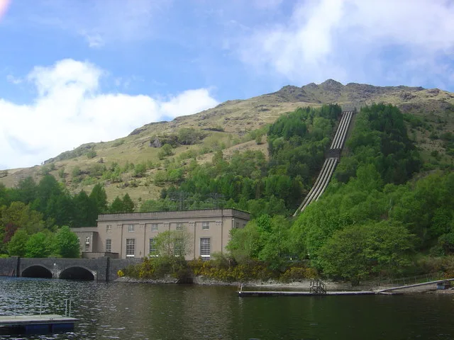
Sloy Power station in Argyll and Bute
Sloy Power station in Argyll and Bute is a power plant (SSE Renewables, hydroelectric). Sloy Power station is also known as Inveruglas, Loch Sloy Hydro-electric Power Station. Sloy Power station is near West Highland Way - Slighe Taobh an Iar na Gàidhealtachd. Ⓦ.
- Building Type
- building
- Land Use
- industrial area
- Operator
- SSE Renewables
Image
Roads nearby
West Highland Way - Slighe Taobh an Iar na GàidhealtachdBalmaha, St. Mocha, Village Shop, Rowardennan, St Fillian's Priory, Peatland Restoration Project, Kirkton, Dumgoyach, Inversnaid Hotel, Ardchoil, Ben Lomond Cottage, Top Up Tap, Honesty Box (self-service), Rowchoish, Beinglas, Beinglas Campsite Shop, Showers, Mill of Ross, Scottish Centre for Ecology and the Natural Environment, Cashell Glen, The Battle of Dalrigh, Derrydarroch, Balmaha Car Park, Balmaha Lodges, Rob Roy's Cave, Sroin Uaidh, Dumgoyne, Turnip The Beet, Local Information Box, Turnip the Beet, Wild Camp (3 Tents), Carmyle Cottage, Holy Pool of St Fillan, Welcome to SRUC Kirkton and Auchtertyre Farms, Holy Pool, Cailness, The Lochan of the Lost Sword, Tyndrum Community Woodland, Bealach Ard, Reception & Shop, The Happy Haggis, The Beech Tree
2,8 km
Tarbet Isle Walk4,0 km
Old Military RoadAldochlay, Bandry
5,0 km
Bemersyde Road5,1 km
Still BraeTarbet Tearoom
5,1 km
Glen Loin Loop5,2 km
Glen Loinn CrescentSuccoth
5,2 km
Ballyhennan CrescentKirk of the Lochs, Three Lochs Way
5,3 km
The Chalets5,3 km
Station roadArrochar and Tarbet
5,5 km
Ardleish pier5,6 km
Body of waters nearby
Lochan Cruachan3,8 km
Loch Sloy5,2 km
Lochan nam Muc5,9 km
Buildings nearby
Inveruglas Telephone Exchange450 m
Sloy Switching Station1,3 km
Inversnaid Telephone Exchange5,1 km
Campsite nearby
Inveruglas camping permit area March-September350 m
Tarbet isle camping permit area March-September4,4 km
MacTavish Campsite5,4 km
Dams nearby
Loch Sloy Dam3,3 km
Loch Arklet Dam3,5 km
Forests nearby
Kenmore Woods3,4 km
Hotels nearby
Inversnaid Bunkhouse2,6 km
Tarbet Hotel5,2 km
Industrial buildings nearby
Valve House, Loch Sloy Hydro-Electric Power Station450 m
Railway lines nearby
West Highland Line5,2 km
Residential buildings nearby
Ardvorich House2,1 km
Rivers nearby
Arklet Water2,8 km
Allt Coriegrogain3,8 km
Streams nearby
Allt Ardvorlich2,0 km
Snaid Burn2,5 km
Inveruglas Water2,6 km
Allt Rostan3,5 km
Easan Dubh3,9 km
Loin Water3,9 km
Allt Sugach4,8 km
Allt Bothan5,0 km
Lag a'Chuirn5,9 km
Valleies nearby
Glen Loin3,5 km
Viewpoint nearby
An Ceann Mòr - Inveruglas Pyramid300 m
Wilderness huts nearby
Doune Byre4,8 km
Woodlands nearby
Inveruglas Isle350 m
Wallace's Isle600 m
Eilean a' Bhùtha3,1 km
Tarbet Isle4,5 km
Other nearby
Inversnaid - Inveruglas200 m
Inveruglas - Tarbet2,4 km
Tarbet - Inversnaid3,6 km
| Inception | 1945 |
|---|---|
| Heritage designation | category A listed building |
| Protected area | Loch Lomond and The Trossachs National Park |
| Located in | Argyll and Bute, Arrochar |
| Country | United Kingdom |
| Body of water | Loch Lomond, Loch Sloy |
| Power output | 152.5 |
| Part of | Sloy-Awe Hydro-Electric Power Scheme |
 Public transport map Argyll and Bute Legend
| Railway | |
| Bus | |
| Tram |
 Cycling map Argyll and Bute Legend
| Cycle path | |
| Cycle lane on road | |
| Cycling on bus lane | |
| Bicycle street | |
| Cyclists allowed | |
| Cyclists allowed, good surface | |
| No cycling | |
| Cobblestones |
| Long-distance cycle route | (depending on scale) | |
| Long-distance cycle route |
 Walking map Argyll and Bute Legend
| Path |
| Long-distance hiking trail | (depending on scale) | |
| Long-distance hiking trail | ||
| No pedestrians |