
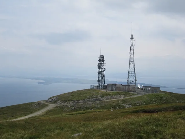
Torosay transmitting station in Argyll and Bute
Torosay transmitting station in Argyll and Bute is an industrial area. Ⓦ.
- Land Use
- industrial area
Image
Body of waters nearby
Loch Bearnach3,8 km
Buildings nearby
An Roth Community Enterprise Centre2,0 km
Craignure Telephone Exchange3,6 km
Ardnadrochet Farm and Cottages4,7 km
Ardchoil4,8 km
Cafés nearby
Blazeys on Mull2,0 km
Arlene's Coffee Shop2,0 km
Campsite nearby
Shieling Holidays2,4 km
Castles nearby
Torosay Castle2,6 km
Cemeteries nearby
Kilpatrick Cemetery4,0 km
Chocolate shops nearby
Isle of Mull Chocolate Company2,0 km
Community centres nearby
Craignure Village Hall2,2 km
Disused railways nearby
Isle of Mull Railway2,5 km
Fire stations nearby
Craignure Fire Station2,1 km
Golf courses nearby
Craignure Golf Club2,8 km
Hospital nearby
Mull and Iona Community Hospital2,6 km
Hostel nearby
Craignure Bunkhouse2,1 km
Hotels nearby
Craignure Inn2,1 km
Isle of Mull Hotel2,1 km
Houses nearby
Heather Cottage3,5 km
Clachan House3,5 km
Maridon3,5 km
Ormaig Croft3,6 km
Wyvern3,7 km
Ardwhin Cottage3,8 km
Glenraille3,8 km
Seilisdeir3,8 km
Redburn3,8 km
Beechcroft3,9 km
Tigh na Sealgair3,9 km
Eastcroft3,9 km
Places of worship nearby
Lochdon Free Church3,7 km
Playgrounds nearby
Craignure Community Play Park2,2 km
Residential buildings nearby
Bowman's Court2,6 km
Rivers nearby
Scallastle River1,9 km
Allt an Dubh-Choire2,3 km
Allt Achadh na Moine4,7 km
Streams nearby
Allt an Fhuar-Ghoirtein1,3 km
Struthan Uachdarach1,7 km
Allt an Uruisge1,9 km
Eas Mòr2,7 km
Allt Beinn nam Meann4,7 km
Other nearby
Craignure2,0 km
Duart2,9 km
Oban - Castlebay4,8 km
| Located in | Torosay, Argyll and Bute |
|---|---|
| Country | United Kingdom |
 Public transport map Argyll and Bute Legend
| Railway | |
| Bus | |
| Tram |
 Cycling map Argyll and Bute Legend
| Cycle path | |
| Cycle lane on road | |
| Cycling on bus lane | |
| Bicycle street | |
| Cyclists allowed | |
| Cyclists allowed, good surface | |
| No cycling | |
| Cobblestones |
| Long-distance cycle route | (depending on scale) | |
| Long-distance cycle route |
 Walking map Argyll and Bute Legend
| Path |
| Long-distance hiking trail | (depending on scale) | |
| Long-distance hiking trail | ||
| No pedestrians |