
Hill of Beath Hawthorn F.C. in Fife
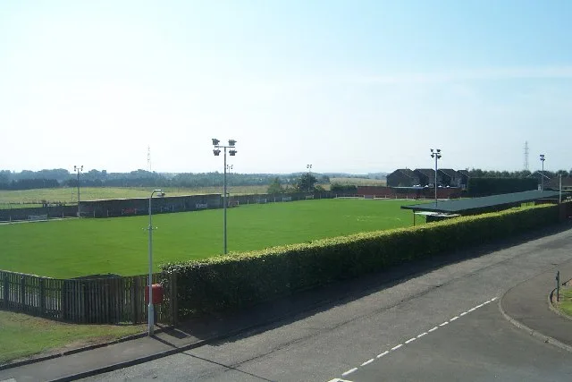
Hill of Beath Hawthorn F.C. in Fife is a sports pitch (Soccer, private, lit, grass). Hill of Beath Hawthorn F.C. is near Hawthorn Crescent. Ⓦ.
- Leisure
- sports pitch
Image
Roads nearby
Hawthorn Crescent100 m
Swintons PlaceHill of Beath
150 m
Dalbeath Gardens150 m
Elm Park200 m
Park Place250 m
Main StreetHill Of Beath Post Office, Swinton's Place, Peking House, Rapid Mini Market, Kingsbarns, The Square, Kingsbarns – The Square, Leuchars, Commerical Arms, Golden Pagoda, SPAR, Leuchars Post Office, JK foods, Nisa, Lochgelly Post Office, Macainsh Parish Church, Buller Street, All in One, Tone & Tan, Home 'n' Hardware, Bayne's, Perfect Pooches, Nardone's Academy of Performing Arts, Body & Glo, David Gray Salons, Carmen Kirk, A & M Tackle, Emperor's Attic, Lumphinnans, Gagarin Way, Primary School, Spar, Benarty Avenue, LOFT, Heavenly Delights, Lochgelly Chinese Takeway, Salon 64, Canmore Dental Practice, MODKING VAPES, Wax melts fife, The Ness, Saline, Oaklea, Main Street, Best Fry Takeaway, Library, Bowling Green, Lomond Pharmacy, Coaltown Post Office, John Ross Place, Post Office, Bellvue, Memorial Hall, D. Allan Funeral Directors, Balgonie Motors, Kingskettle, Scissors, Greens of Crossford, Aura Beauty, Beechwood, Cairneyhill, HB4 Hair Salon, La Vida Boutique, Scotmid, Renaissance, Muirside Grove, Brandy Riggs, War Memorial, Cairneyhill Post Office, Kelty, Well Pharmacy, Kelty Community Centre, Premier, Coral, Ola Cafe Deli, Caspians, La çor, Dears Pharmacy, Crown Hotel, Kelty Primary School, Community Centre, Kelty Library, Guardbridge, Something Different, Innerbridge Street, Tindal’s Café, Stewart Street, Forest Road, Garden Court, Main Street Turning Circle, Care Pharmacy, China Blue, Springfield Post Office, Concrete Works, Malagan, IEM Coachworks, Milton of Balgonie, West Wemyss, Belvedere Hotel, Co-op Food, Station Hotel, Thornton, The Fish Hoose, Davidsons Chemists, Toby's Fish & Chips, Thomson Butchers, Bulmullo Inn, Low Valleyfield, Main Street West, Forth View Cottages, Torryburn, Eilean Lane, Parish Church, Toll Road, The White Gates, Porterfield, Comrie, Carnock, The Carnock Inn, Bowhill, Wallsgreen Gardens, The Auld Hoose, Bonhard Road, Henderson Street, Upper Largo, Upper Largo Hotel & Restaurant, Upper Largo Chandlery, The Barnyard, Guitar Lessons Fife, Dairsie, Dairsie Post Office, Gulf, Dairsie Mini-Mart, Darsie Inn, Fantastic Campervans, Pitcairn Park, Limekilns Mobile Service Post Office, Sundial Cafe, The Kilns, Limekilns Bistro, Coorie by the Coast, Dunshalt Shop, Ceres Post Office, Halbeath, Halbeath Main Street, Armando's Fish Bar, Coaltown of Wemyss, Coaltown Of Wemyss Post Office, Coaltown Village Corner Shop, South Row, BP, The Auld Inn, Colinsburgh Galloway Library, Tinian Crescent, Wee Chief, Westcroft Way, Newmills, The Crown, Durham Terrace, The Crown Inn, Crosshill, The Inn at Kingsbarns, Kingsbarns Bed and Breakfast, Kilconquhar Book Swap, The Bruce Arms, Forth View Industrial Estate, Carnock Primary School, Church Street, Kinglassie, Lochty Avenue, Kinglassie Post Office, Premier Kinglassie Minimarket, Nesscafe, Catherine Terrace, Mirror Mirror, X HILL CAR WASH, Hugo Avenue, Castaway Cottage, The Crusoe, Lower Largo, Obelisk, The Tavern, Rosemill Court
250 m
Farm View300 m
Hilltops300 m
Torbeith Gardens300 m
Torbeith RoadCutting Edge Carpets
350 m
Mitchell Crescent400 m
Netherbeath RoadNetherbeath Road
550 m
Allan Park600 m
Burnside Terrace600 m
Sawers Close600 m
Sinclair DriveMaxwell Crescent, Mossend Terrace
700 m
Woodend PlaceAllan Park, Reid Avenue, Gardiner Place
700 m
Beath View Road750 m
MossbankBeath View Road
750 m
Green Mount800 m
Gardiner Place800 m
Maxwell Crescent800 m
Dalbeath Crescent850 m
Braemount900 m
John Wood Place1000 m
Old Perth RoadGateside Industrial Estate, Old Perth Road
1000 m
Ewing Street1000 m
Church Place1,0 km
Brands Row1,1 km
Ramsey Crescent1,1 km
Well Crescent1,1 km
Amenities nearby
Hill of Beath Nursery and Community Hub350 m
Constructions nearby
Mains of Beath850 m
Convenience stores nearby
D & F Stores950 m
Co-op Food950 m
Doctor's practice nearby
Crossgates Medical Practice950 m
Fast food restaurants nearby
Beath Fry950 m
Meadows nearby
The Taft1000 m
Nature reserves nearby
Dalbeath Marsh Local Nature Reserve750 m
Places of worship nearby
Trinity Church1,0 km
Railway lines nearby
Fife Circle Line950 m
Razed railways nearby
Dalbeath Colliery500 m
Social facilities nearby
Craigie House900 m
Alexander House900 m
Sports centres nearby
Keir's Park150 m
Streams nearby
Lochgelly Burn550 m
Mowbray Burn900 m
Variety stores nearby
The Original Factory Shop850 m
Other nearby
Hill of Beath250 m
| Inception | 1975 |
|---|---|
| Country | United Kingdom |
 Public transport map Fife Legend
| Railway | |
| Bus | |
| Tram |
 Cycling map Fife Legend
| Cycle path | |
| Cycle lane on road | |
| Cycling on bus lane | |
| Bicycle street | |
| Cyclists allowed | |
| Cyclists allowed, good surface | |
| No cycling | |
| Cobblestones |
| Long-distance cycle route | (depending on scale) | |
| Long-distance cycle route |
 Walking map Fife Legend
| Path |
| Long-distance hiking trail | (depending on scale) | |
| Long-distance hiking trail | ||
| No pedestrians |