
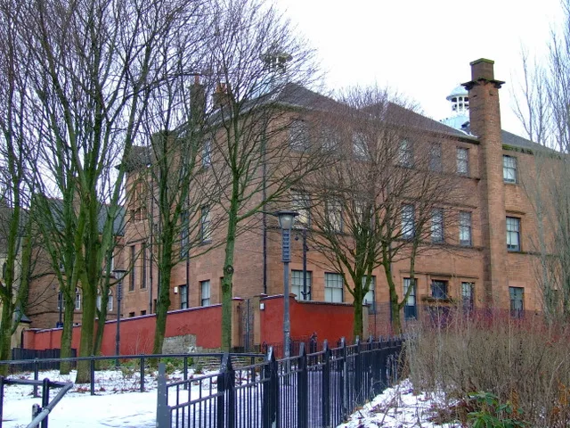
Martyr's Public School in Glasgow City
Martyr's Public School in Glasgow City is a building, Parson Street (G4 0PX). Martyr's Public School is built in the Art Nouveau architecture style. Ⓦ.
- Postal Code
- G4 0PX
- Street
- Parson Street
- Building Type
- building
Image
Bicycle hires
Charging stations
Bicycle parkings
Restaurants
Bus stops
Cafés
Off-licences
Holiday apartment
Artwork
Public clocks
Roads nearby
Parson Street50 m
Stirling RoadGlasgow, Stirling Road/ St James Road, Stirling Road / St James Road
150 m
Glebe Street150 m
McAslin Street150 m
McAslin Court200 m
Glebe Court250 m
Stair D300 m
Cathedral StreetGlasgow Queen Street (High Level), Born In Scotland, Goldsmiths, Arran Sense of Scotland, Glasgow Cathedral Bridge (above), Best Kebab, GamerSheek, Jones Bootmaker, Boux Avenue, Flying Tiger Copenhagen, Trespass, The Perfume Shop, Cathedral Street / North Frederick Street, Cathedral Street / Collins Street, Glasgow Cathedral, Sainsbury's Local, Cathedral Street / Buchanan Street, bareMinerals, Millie's Cookies, Costa, Fuel Juice Bar, Greggs, Next, Stag, Accessorize, The Fragrance Shop, Pandora, Clintons, Hotter, Lovisa, Ernest Jones, Boots, claire's, Smiggle, H.Samuel, Hollister, Typo, Lego, Swarovski, Quiz, Scottish Design Exchange, Ecco, Foodies By SDX, Smile Direct Club, The Entertainer, Lakeland, Build-A-Bear Workshop, Vision Express, Glasgow Children's Hospital Charity, Starbucks, Phase Eight, Krispy Kreme, Frozen Kiosks, The Whisky Shop, Golden Spoon, Burger King, Koumi, Kim's, Cathedral Street / Taylor Street, University of Strathclyde North, Curran Hub, Cathedral Street / College of Commerce, Cathedral Street / Allen Glen Place
300 m
Stair C300 m
Taylor Place300 m
St. Mungo PlaceTownhead Tree
300 m
Stair F300 m
Collins Street350 m
Taylor Street350 m
Black Street400 m
St James RoadNourish @ The Streat, Nourish @ Aura, Nido St. James - Student accomodation, RaceTrack, St James Road / Glebe Street, St James Road / Stirling Road
400 m
Baird StreetTownhead Interchange, RS, Glasgow, Baird Street/ Black Street, Glasgow, Baird Street/ Lister Street
400 m
Weaver StreetAroma, Strathclyde Nursery
400 m
Lister Street400 m
Pinkston RoadRoyston, Baird Street/ Pinkston Road, Pinkston, Pinkston Road / Baird Street Police Station
450 m
CuddiesSighthill Stone Circle
600 m
Apartment buildings nearby
2 Taylor Place350 m
7 St. Mungo Place350 m
Buildings nearby
St Mungo's Church Hall100 m
Surgical Block150 m
Gatehouse Building250 m
Car dealerships nearby
Tesla - Glasgow350 m
Community centres nearby
Townhead Village Hall300 m
Gardens nearby
Saint Nicholas Garden350 m
Industrial buildings nearby
John Lewis PLC500 m
Libraries nearby
University of Strathclyde Library300 m
Places of worship nearby
Saint Mungo's50 m
Destiny Church250 m
Pubs nearby
The Howgait200 m
Razed railways nearby
Garnkirk and Glasgow Railway550 m
Residential buildings nearby
Garnett Hall300 m
Murray Hall350 m
Birkbeck Court350 m
James Goold Hall (Block B)450 m
St Mungo's Student Accommodation450 m
Forbes Hall450 m
Sports centres nearby
Power League250 m
Strathclyde Sport400 m
Lister Street Bowls400 m
University buildings nearby
Lord Hope Building350 m
The Lord Todd - Village Office400 m
Hamnett Wing400 m
Robertson Wing (Arbuthnott)400 m
Wolfson Centre450 m
| Architectural style | Art Nouveau architecture |
|---|---|
| Heritage designation | category A listed building |
| Located in | Glasgow City, Glasgow |
| Country | United Kingdom |
 Public transport map Glasgow City Legend
| Railway | |
| Bus | |
| Tram |
 Cycling map Glasgow City Legend
| Cycle path | |
| Cycle lane on road | |
| Cycling on bus lane | |
| Bicycle street | |
| Cyclists allowed | |
| Cyclists allowed, good surface | |
| No cycling | |
| Cobblestones |
| Long-distance cycle route | (depending on scale) | |
| Long-distance cycle route |
 Walking map Glasgow City Legend
| Path |
| Long-distance hiking trail | (depending on scale) | |
| Long-distance hiking trail | ||
| No pedestrians |