
Dunnet Head Lighthouse in Highland
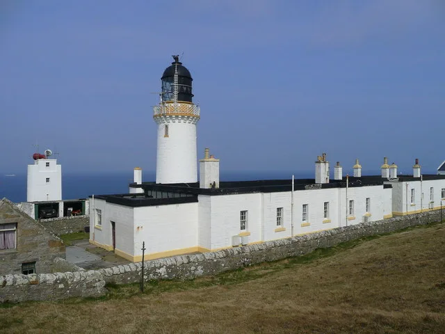
Dunnet Head Lighthouse in Highland is a lighthouse (elevation 20 m). Dunnet Head Lighthouse is also known as Ceann Dùnaid. Dunnet Head Lighthouse is near Courtfall Road. Ⓦ.
- Building Type
- building
Image
Roads nearby
Courtfall Road3,0 km
Headwark RoadBrough, Ocean View
3,9 km
Heatherbell RoadLetterbox
4,0 km
Ivy Cottage Road4,2 km
St. John's Road4,2 km
Hill of Dunnet Road4,5 km
West Dunnet Road5,1 km
Ness Road5,5 km
Dwarwick Pier5,5 km
Dwarwick Pier Road5,5 km
Dwarwick Place5,8 km
Seaview CottagesDunnet
5,8 km
Hill of Rattar Road6,3 km
Scarfskerry Pier Road6,3 km
Burn Road6,7 km
Mountain Bike Technical Trail6,7 km
Hillview Road6,8 km
Red All-Abilities TrailThe Log Cabin, Xylophone
6,9 km
Lochyside Road6,9 km
The Avenue6,9 km
Blue Horse TrailTotem Poles, Bird Hide
7,1 km
Nature nearby
Little Clett3,1 km
Body of waters nearby
Loch of Easter Head650 m
Loch Burifa'700 m
Long Loch800 m
Sanders Loch1,5 km
Many Lochs1,9 km
Black Loch2,2 km
Nether Sanders Loch2,5 km
Grassy Loch2,5 km
Courtfall Loch3,0 km
Loch of Muirs3,3 km
Loch of Bushta4,2 km
St John's Loch5,6 km
Loch of Mey7,2 km
Buildings nearby
Keepers cottage50 m
Coastguard Cottages300 m
Barrock Telephone Exchange6,0 km
Dunnet Pavilion6,5 km
Campsite nearby
WIndhaven3,5 km
Caravan site nearby
Dunnet Bay Caravan Club Site6,7 km
Pavilions nearby
Pentland United F.C.5,7 km
Places of worship nearby
Dunnet Church5,8 km
Residential areas nearby
The HavenWhaligoe steps, Whaligoe
6,2 km
Sports pitches nearby
Ham Park5,8 km
Streams nearby
Burn of Dunnet5,8 km
Burn of Instack6,2 km
Burn of Helshigrow6,5 km
Burn of Rattar7,3 km
| Inception | 1831 |
|---|---|
| Operator | Northern Lighthouse Board |
| Heritage designation | category B listed building |
| Located in | Highland, Dunnet |
| Country | United Kingdom |
| Significant event | automatization |
| Location | Dunnet Head |
| Part of | Dunnet Head Lighthouse & Keepers' House |
 Public transport map Highland Legend
 | Railway | |
| Bus | |
| Tram |
 Cycling map Highland Legend
 | Cycle path | |
| Cycle lane on road | |
| Cycling on bus lane | |
| Bicycle street | |
| Cyclists allowed | |
| Cyclists allowed, good surface | |
| No cycling | |
| Cobblestones |
| Long-distance cycle route | (depending on scale) | |
| Long-distance cycle route |
 Walking map Highland Legend
 | Path |
| Long-distance hiking trail | (depending on scale) | |
| Long-distance hiking trail | ||
| No pedestrians |