
Kilmuir Easter in Highland
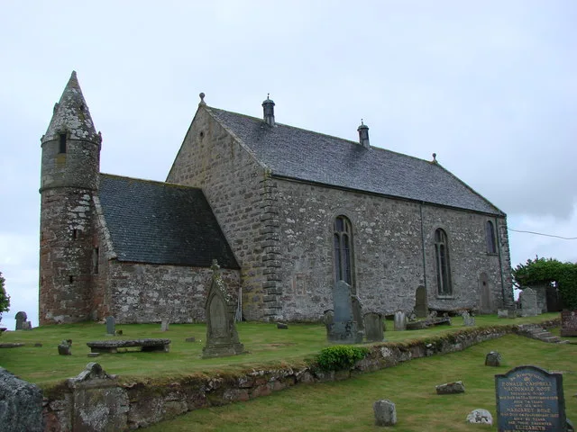
Kilmuir Easter in Highland is a Presbyteriana church. It is near Tarbat Cottages Lane and is also known as Kilmuir Easter, Parish Church. The church is a listed building. Ⓦ.
- Amenity
- place of worship
- Building Type
- church
- Operator
- Church of Scotland
Image
Roads nearby
Portleich RoadNursing Home
850 m
Tarbat Cottages LaneTarbat Cottages
900 m
Wester Tarbat1000 m
Dewing Close1,1 km
Highland Park1,2 km
Ross CrescentPrimary School Road End, Church, Chanonry Park
1,2 km
School RoadPrimary School Road End, Lazy Crofter Bunkhouse/Hostel, Ardnamurchan High School, Àrainn Shuaineirt, UHI West Highland - Strontian, Strontian, North Ballachulish, Kinlochleven Road End, Chocolates of Glenshiel
1,3 km
Woodlands Drivemercat cross
1,3 km
Cromarty Drive1,3 km
Drovers WayMilton
1,3 km
Sutor ViewTelephone Box, Barbaraville
1,3 km
Old Station Road1,4 km
Munro Crescent1,4 km
Milton Woods Path1,4 km
Milton MillMilton Inn
1,4 km
Old Mill RoadShop, Primary School
1,4 km
Urquhart Close1,5 km
ParkhillKen's Garage
2,1 km
Parkside2,2 km
Meddat Bridge2,3 km
Not adopted3,1 km
Meddat Road3,2 km
Eilidh's Steps3,2 km
Buildings nearby
Kildary Telephone Exchange350 m
Mercat Centre1,6 km
log cabin1,7 km
Balnagown2,1 km
Delny House Hotel & Restaurant2,5 km
Shandwick House3,4 km
The Old Manse3,6 km
Cemeteries nearby
Logie Easter Cemetery3,4 km
Convenience stores nearby
Milton Store1,4 km
Farmyards nearby
Shandwick Mains3,9 km
Forests nearby
Balnagown Wood2,0 km
The Wilderness3,4 km
Hotels nearby
Shandwick Inn3,0 km
Huts nearby
Boat House3,1 km
Industrial buildings nearby
MacKay Steelwork & Cladding1,5 km
Delny Bark Products1,5 km
Places of worship nearby
Logie Easter3,2 km
Railway lines nearby
Far North Line1,7 km
Residential buildings nearby
Tarbat House1,3 km
Rivers nearby
Balnagown River2,2 km
Roof structures nearby
Woodland Barn1,7 km
Streams nearby
Burn of Tullich1,6 km
Pollo Burn1,9 km
Delny Burn2,1 km
Larack Burn2,7 km
Kindeace Burn2,8 km
| Located in | Highland, Kilmuir Easter |
|---|---|
| Country | United Kingdom |
 Public transport map Highland Legend
| Railway | |
| Bus | |
| Tram |
 Cycling map Highland Legend
| Cycle path | |
| Cycle lane on road | |
| Cycling on bus lane | |
| Bicycle street | |
| Cyclists allowed | |
| Cyclists allowed, good surface | |
| No cycling | |
| Cobblestones |
| Long-distance cycle route | (depending on scale) | |
| Long-distance cycle route |
 Walking map Highland Legend
| Path |
| Long-distance hiking trail | (depending on scale) | |
| Long-distance hiking trail | ||
| No pedestrians |