
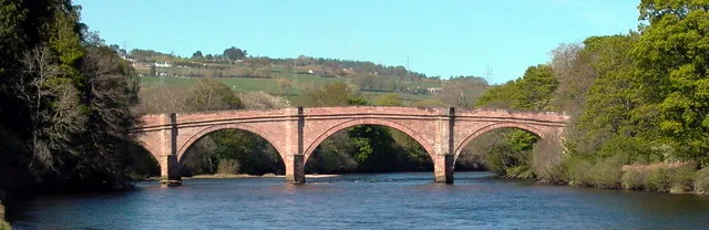
Lovat Bridge in Highland
Lovat Bridge in Highland is a single-lane, asphalted, unlit main road. The road has sidewalks (asphalt), cycle paths (cycle lane) as well as a road width of 5 m. This road is part of the long-distance roads Gritting Priority 1 roads, Moray Firth Tourist Route and North Coast 500. The bus line 28 runs along this road. Ⓦ.
- Road Type
- main road
- Lanes
- 1
- Speed Limit
- 60 mph
Image
Roads nearby
Wester Balblair Road700 m
Altyre RoadWester Balblair, Cruachan Bed & Breakfast
750 m
Aird RoadArdheslaig, Road End
950 m
Maple Vale1,0 km
Station RoadMallaig, The Tea Garden Cafe, Marine Hotel, Marine Bar, The Co-operative Food, The Fishmarket, Ticket Office, J. Lawrie & Sons, An Cala, The Mallaig Cafe, Art Gallery and Crafts, Mallaig Toys & Gifts, The Highlands Koo Company, The Mission Bunkhouse, RNLI Shop, Welcome to Mallaig, Boots, Cromarty Bakery Shop, Nethy Bridge Hotel, Spean Bridge, Old Station Restaurant, Kyle of Lochalsh, Lochalsh Butchers, Kyle Post Office, Kyle Surgery, Mace, Skye & Lochalsh Dental Practice, Skye Bridge Distillery, The Islander, The Silver Seal, rightmedicine Pharmacy, Skye Car Hire, Skye Bridge Hotel, Central Filling Station, M & D MacLeod Funeral Directors, Achnasheen Terraces, Bridgend Filling Station, Beaufort Gardens, Beauly Laundry, Fort Augustus, The Lovat, Richmond House Hotel Bar & Restaurant, Angela‘s Giftshop, Richmond House Hotel, Bank House B&B, Kings Inn B&B, Beaufort House B&B, Caledonian Cottage B&B, Lorien House B&B, The Brasserie, Beauly, Beauly Railway Station, Dalwhinnie, Station Road End, 11. The Long Goodbye, Station Road, Conon Bridge, Arisaig, The Speyside Way, Golspie, Hospital Road, The Brown Trout, Glenglass Road Junction, Dingwall Railway Station, Kylelachin B&B, Garfield Guest House, Urrard B&B, Bus Shelter, Heather hut, Garve, Newtonmore, Badenoch, Melon Patch B&B, Istanbul Kebab House, Carrbridge Artists Studio, The Old Bank House, Visitor Centre, Lochluichart, Plockton, Plockton Car Park, Tain, Station Road Entrance, Platform 1864, Achnasheen, Achnasheen Post Office, Station, Morrisons Daily, Church, Ardersier Memorial Fountain, The Gun Lodge, Inchrye B&B, McLeod Farm Centre, Ardersier Station Road, Police Station, Ardersier Post Office, SPAR, Wendys Cafe, Post Office, Star Inn, Waterside, Kyle Station Museum
1,0 km
Farlie View1,1 km
Priory Place1,1 km
Pritchard Crescent1,1 km
Kings Court1,1 km
Beaufort GardensSpar, Self service laundry
1,2 km
Priory Gardens1,2 km
Priory WalkBeauly Post Office, Co-op Food
1,2 km
Priory Road1,2 km
Garden Place1,3 km
Bridgend1,3 km
Simpson Park1,3 km
Priory Crescent1,3 km
Priory Way1,3 km
Cnoc-na-Rath Countryside Walkway1,3 km
Braeview Park1,4 km
Viewfield AvenueBoots, Highland Hospice
1,5 km
Balmanach CourtMorisons Ironmongers, Campbell & Co, Fraser Optical, Iain Marr Antiques, Downright Gabbler
1,6 km
Croyard ParkAird Motors, Beauly Library
1,6 km
Croyard RoadLucky Ly, Highland Health Veterinary Care
1,7 km
Shops nearby
Ffordes Photographic800 m
Bars nearby
Captain Faff's Bar50 m
Buildings nearby
Beauly Holiday Park Reception and Shop100 m
Beauly Shinty Club1,5 km
Lovat Estates Office1,6 km
Aird House1,6 km
Masonic Meeting Hall1,7 km
Caravan site nearby
Beauly Holiday Park550 m
Community centres nearby
Phipps Hall1,5 km
St Columba Hall1,7 km
Doctor's practice nearby
Croyard Road Surgery1,7 km
Guest house nearby
Craigrathan1,4 km
Gruinard Guest House1,5 km
Chrialdon House Bed and Breakfast1,5 km
Heathmount Guest House1,5 km
Hotel nearby
Lovat Arms Hotel1,6 km
Houses nearby
Cnocend1,7 km
Industrial areas nearby
Beauly Quarry350 m
Office buildings nearby
Global Infrastructure Ltd400 m
Places of worship nearby
The Free Presbytarian Church of Scotland700 m
Beauly Free Church1,7 km
Beauly Church1,7 km
Railway lines nearby
Far North Line1,1 km
Rivers nearby
River Beauly150 m
Sports pitches nearby
Beauly Bowling Club1,5 km
| Inception | 1810 |
|---|---|
| Commissioned by | Commissioners of Highland Roads and Bridges |
| Located in | Highland, Kiltarlity and Convinth |
| Country | United Kingdom |
| Crosses | River Beauly |
| Carries thoroughfare | A862 road |
 Public transport map Highland Legend
 | Railway | |
| Bus | |
| Tram |
 Cycling map Highland Legend
 | Cycle path | |
| Cycle lane on road | |
| Cycling on bus lane | |
| Bicycle street | |
| Cyclists allowed | |
| Cyclists allowed, good surface | |
| No cycling | |
| Cobblestones |
| Long-distance cycle route | (depending on scale) | |
| Long-distance cycle route |
 Walking map Highland Legend
 | Path |
| Long-distance hiking trail | (depending on scale) | |
| Long-distance hiking trail | ||
| No pedestrians |