
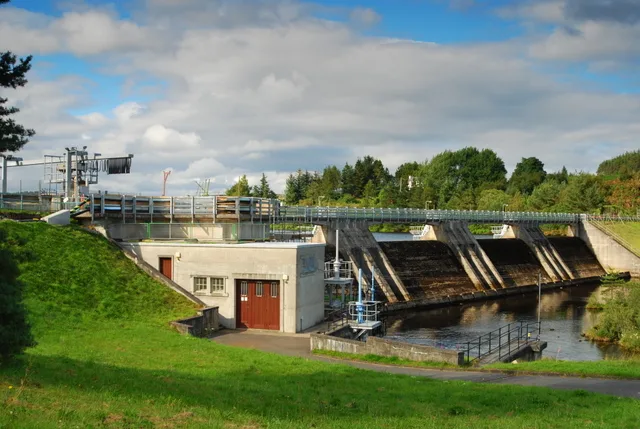
Shin Diversion Weir in Highland
Shin Diversion Weir in Highland is a weir.
- Building Type
- building
- Land Use
- industrial area
- Operator
- SSE Renewables
- Waterway Type
- weir
Image
Roads nearby
Ord Crescent850 m
The TerraceHawthornlea
850 m
The Black Bridge900 m
Ord PlaceGulf
900 m
Ferrycroft1,0 km
Ferrycroft Cottages1,1 km
Quarry Cottage Road1,1 km
Glen Burn1,2 km
Builnatobernich RoadBuilnatobernich
1,2 km
Sutherland Arms Way1,2 km
Park RoadParkview Bed and Breakfast, Quarry Cottages, Ballachulish, Park Avenue Road Junction
1,2 km
School RoadLazy Crofter Bunkhouse/Hostel, Primary School Road End, Ardnamurchan High School, Àrainn Shuaineirt, UHI West Highland - Strontian, Strontian, North Ballachulish, Kinlochleven Road End, Chocolates of Glenshiel
1,3 km
Hotel Road1,3 km
Main StreetPost Office, Monarch Country Apartments, Toshac's Tuck Shop & Tea Room, The Wild Flour, Antlers Cafe, Mehmood's Curry House, Caledonian Hotel, Portmahomack Post Office, The Oystercatcher, Portmahomack Harbour Street Fountain, Lochcarron, Rockvilla Hotel, The Bistro, Waterside Cafe, Lochcarron Post Office, Pathend Bed and Breakfast, Bank of Scotland, Kyle of Lochalsh Library, RBS, Norwest Bar, Hector's 2 Go, Haircraft, Skye Beauty, Computer & Hi-Fi Solutions, Kyle Chinese, Primary School, Kessock Post Office, Old Ferry Pier, White Cottage Tearoom, Mission Hall, North Kessock Dental Practice, Drill Hall, Gulf, Golspie, o/s Stags Head Hotel, Car Park, opp Stags Head Hotel, Nisa, Stags Head Hotel, The Trawler, Lindsay & Co, Golspie Stone Shop, The Salt House, Identity, Tyke's Charity Shop, Chip Shop, Balintore Post Office, Spar, Fearn Hall, Fearn Hotel, Ben Loyal Hotel, Tongue, Tongue Post Office, Tongue Deli & Coffee Shop, Tigh-nan-Ubhal, Ben Loyal, Culbokie Post Office O/S, Culbokie Post Office, Inver, Balavil Sport Hotel, Coop, Clune House, Village Green, Schoolhouse Pottery, Community Centre, Newtonmore, History of Newtonmore, A836 and A839 Junction
1,3 km
Lairg Industrial Estate1,3 km
Sutherland Court1,3 km
Laundry Road1,3 km
Church Hill RoadLairg
1,4 km
Clash Breac1,4 km
Gruide Road U2097Gruids Milton, Pitarxie
1,5 km
Amenities nearby
Lairg and District Learning Centre1,3 km
Railways nearby
Lairg Civil Engineer's Sidings1,3 km
Shops nearby
Lairg Auction Mart1,4 km
Buildings nearby
Holtey Classic Hand Planes1,3 km
Lairg Telephone Exchange1,4 km
Roads Depot1,4 km
Campsite nearby
Lairg Glamping Pods1,4 km
Car repair shops nearby
Lairg Garage1,3 km
Caravan site nearby
Lairg Caravan Park1,2 km
Clothing shops nearby
The Sutherland Sporting Tweed Company1,2 km
Community centres nearby
Lairg Community Centre1,3 km
Convenience stores nearby
Costcutter850 m
Doctor's practice nearby
Lairg Medical Practice1,3 km
Fire stations nearby
Lairg Community Fire Station1,3 km
Guest house nearby
Carnbren Bed & Breakfast800 m
Hairdresser's nearby
Iona's1,2 km
Hotels nearby
Lairg Highland Hotel1,2 km
Museum nearby
Ferrycroft Visitor Centre1,0 km
Places of worship nearby
Lairg Free Church750 m
Church of Scotland Lairg1,4 km
Post depots nearby
Royal Mail1,3 km
Railwaies nearby
Lairg Oil Terminal1,3 km
Railway lines nearby
Far North Line950 m
Rivers nearby
River Shin50 m
Sports pitches nearby
Ferrycroft Park1,1 km
Streams nearby
Allt Tomich800 m
Torroboll Burn1,1 km
Allt Domhain1,5 km
Woodlands nearby
Church Hill Woodland1,4 km
| Located in | Highland, Lairg |
|---|---|
| Country | United Kingdom |
| Body of water | River Shin |
 Public transport map Highland Legend
| Railway | |
| Bus | |
| Tram |
 Cycling map Highland Legend
| Cycle path | |
| Cycle lane on road | |
| Cycling on bus lane | |
| Bicycle street | |
| Cyclists allowed | |
| Cyclists allowed, good surface | |
| No cycling | |
| Cobblestones |
| Long-distance cycle route | (depending on scale) | |
| Long-distance cycle route |
 Walking map Highland Legend
| Path |
| Long-distance hiking trail | (depending on scale) | |
| Long-distance hiking trail | ||
| No pedestrians |