
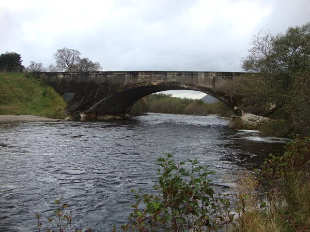
Spey Bridge in Highland
Spey Bridge in Highland is a two-lane, asphalted, unlit secondary road. The road has sidewalks. There is no cycle path. This road is part of the bicycle routes UK:National Cycle Network 7 and EuroVelo 1 - Atlantic Coast Route - part United Kingdom 1 and the long-distance road "Gritting Priority 1 roads". Spey Bridge is also known as Newtonmore, Spey Bridge.
- Road Type
- secondary road
- Lanes
- 2
- Speed Limit
- 60 mph
Image
Roads nearby
The Wildcat TrailThe Coffin Road
100 m
Coffin RoadThe Coffin Road
400 m
Dràibh a' Chatanaich450 m
St Columba Road650 m
Laggan Road750 m
Station RoadMallaig, The Tea Garden Cafe, Marine Hotel, Marine Bar, The Co-operative Food, The Fishmarket, Ticket Office, J. Lawrie & Sons, An Cala, The Mallaig Cafe, Art Gallery and Crafts, Mallaig Toys & Gifts, The Highlands Koo Company, The Mission Bunkhouse, RNLI Shop, Welcome to Mallaig, Boots, Cromarty Bakery Shop, Nethy Bridge Hotel, Spean Bridge, Old Station Restaurant, Kyle of Lochalsh, Lochalsh Butchers, Kyle Post Office, Kyle Surgery, Mace, Skye & Lochalsh Dental Practice, Skye Bridge Distillery, The Islander, The Silver Seal, rightmedicine Pharmacy, Skye Car Hire, Skye Bridge Hotel, Central Filling Station, M & D MacLeod Funeral Directors, Achnasheen Terraces, Bridgend Filling Station, Beaufort Gardens, Beauly Laundry, Fort Augustus, The Lovat, Richmond House Hotel Bar & Restaurant, Angela‘s Giftshop, Richmond House Hotel, Bank House B&B, Kings Inn B&B, Beaufort House B&B, Caledonian Cottage B&B, Lorien House B&B, The Brasserie, Beauly, Beauly Railway Station, Dalwhinnie, Station Road End, 11. The Long Goodbye, Station Road, Conon Bridge, Arisaig, The Speyside Way, Golspie, Hospital Road, The Brown Trout, Glenglass Road Junction, Dingwall Railway Station, Kylelachin B&B, Garfield Guest House, Urrard B&B, Bus Shelter, Heather hut, Garve, Newtonmore, Badenoch, Melon Patch B&B, Istanbul Kebab House, Carrbridge Artists Studio, The Old Bank House, Visitor Centre, Lochluichart, Plockton, Plockton Car Park, Tain, Station Road Entrance, Platform 1864, Achnasheen, Achnasheen Post Office, Station, Morrisons Daily, Church, Ardersier Memorial Fountain, The Gun Lodge, Inchrye B&B, McLeod Farm Centre, Ardersier Station Road, Police Station, Ardersier Post Office, SPAR, Wendys Cafe, Post Office, Star Inn, Waterside, Kyle Station Museum
750 m
Woodside Avenue800 m
Perth RoadClan McPherson Museum, Londis, Anne Connolly Osteopath, Harris Tweed & Highland Shop
800 m
Croftroy850 m
Lodge Park900 m
Loch na Leoba Road900 m
Craig Dhu Court1000 m
Loch na Leoba Place1000 m
Old Glen Road1,0 km
Glen Grove1,0 km
Craigdhu Road1,1 km
Glen RoadLearn & Create, Squirrel View, Netherwood
1,2 km
Glenbanchor RoadGlen Banchor environmental enhancements
1,3 km
Body of waters nearby
Loch na Leoba1,1 km
Buildings nearby
Newtonmore Telephone Exchange750 m
Cemeteries nearby
Banchor Cemetery1000 m
Chalet nearby
Balvatin Cottages600 m
Erindearn700 m
Woodlands750 m
Fronthill1000 m
East Croftroy1,1 km
Constructions nearby
Spey Green650 m
Detached houses nearby
Badenoch750 m
Biallaid House800 m
Sunny Brae850 m
WestwoodSaltburn Road
850 m
Monadhliath1000 m
Farmyards nearby
Banchor Mains800 m
Guest house nearby
Spey Valley Lodge650 m
The Dower House700 m
Eagle View Guest House850 m
Coig na Shee850 m
Hostel nearby
Newtonmore Hostel1,0 km
Hotel nearby
The Glen Hotel950 m
Museum nearby
Clan McPherson House & Museum950 m
Parks nearby
Jack Richmond Memorial Woodland Park650 m
Railway lines nearby
Highland Main Line500 m
Recreation grounds nearby
The Eilean100 m
Restaurants nearby
Newtonmore Grill500 m
Rivers nearby
River Calder350 m
Shelters nearby
Newtonmore Shinty Pavilion250 m
Social facilities nearby
Travellers Site700 m
Mains Care Home1000 m
Sports pitches nearby
Training Pitch200 m
| Heritage designation | category B listed building |
|---|---|
| Protected area | Cairngorms National Park |
| Located in | Highland, Kingussie and Insh |
| Country | United Kingdom |
| Crosses | River Spey |
| Carries thoroughfare | B9150 road |
 Public transport map Highland Legend
 | Railway | |
| Bus | |
| Tram |
 Cycling map Highland Legend
 | Cycle path | |
| Cycle lane on road | |
| Cycling on bus lane | |
| Bicycle street | |
| Cyclists allowed | |
| Cyclists allowed, good surface | |
| No cycling | |
| Cobblestones |
| Long-distance cycle route | (depending on scale) | |
| Long-distance cycle route |
 Walking map Highland Legend
 | Path |
| Long-distance hiking trail | (depending on scale) | |
| Long-distance hiking trail | ||
| No pedestrians |