
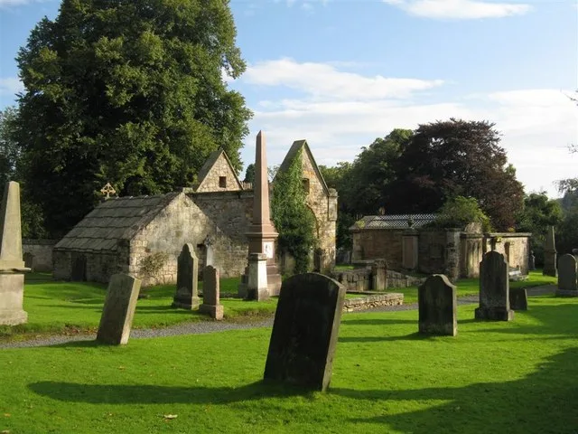
Lasswade Old Kirkyard in Midlothian
Lasswade Old Kirkyard in Midlothian is a cemetery. Lasswade Old Kirkyard is also known as Lasswade old parish church. Lasswade Old Kirkyard is near Lasswade Road.
- Amenity
- cemetery
- Land Use
- cemetery
Image
Pubs
Restaurants
Pharmacy
Bus stops
Fast food restaurants
Kitchen showrooms
Cafés
Roads nearby
Coffin Lane100 m
School Green Close100 m
Lasswade Court100 m
School Brae150 m
School Green150 m
Lasswade RoadLasswade Road, Costcutter, Three Craws, Eskbank Antiques, Station Road, Haveral Wood, South Melville, Wester Melville
150 m
High StreetPandora's Box, Han's Sweets'N'Eats, The Old Crown Inn, Food Lodge, Giovanni, Lord Of The Noodles, Gravity Bottleshop, Massaro's, Lambs Pend, Cavaliere, M & A Dog Grooming, Pizzeria & Fish Bar, Bonfire, Franco's, Corn Exchange, Dalkeith Parish Church, Barn, Rustic Roots, Lavender Coffee and Crumbs Café, Dalkeith, The Ship Inn, DIVA, Oxfam, VPZ, Luvely, Boots, RBS, Black & Lizars, Bank of Scotland, Superdrug, AZTel, B&M Bargains, Cancer Research UK, News Centre, The Salvation Army, Semichem, With Love, boombarbers, Bon Bon, Dalkeith Pet Store, Specsavers, Luxury Nails & Spa Dalkeith, Bonnyrigg, The Anvil Inn, Rowlands Pharmacy, High Street, Gloria's, Park Road, Mayflower, Canton, Bombay Spice, Coffee Fresco, Park Road (High Street), Greggs, Colin's, Bayne's, Hong Kong, The Old Well, Tanz Tanning, Marmaris, Gurkhas, Gordon Vets, The Storehouse, Academy Lane, Laird & Dog, Diamodis Interiors, Laird and Dog, Luci’s Modern Italian, Lasswade, Rockville Terrace, Coop Car Park, Station Road
150 m
Church Road200 m
Westmill Wynd200 m
Melville View250 m
West Mill Pend300 m
Elm RowElm Row
300 m
Westmill Haugh300 m
Cuguen Place350 m
Wee Brae400 m
Melville Dykes RoadSouth Melville Farm
400 m
HillheadBroomieknowe Gardens
400 m
Polton RoadPolton Road
400 m
Westmill Road450 m
Hillhead Court450 m
Lasswade Viaduct450 m
Green Lane500 m
Glebe Place500 m
Grove End550 m
Broomieknowe600 m
Upper Broomieknowe600 m
Wadingburn Lane650 m
Lower Broomieknowe650 m
Wadingburn RoadKevock Road
650 m
Abandoned railways nearby
Esk Valley Junction to Polton Junction Branch400 m
Broomieknowe Tunnel500 m
Buildings nearby
Lasswade Pavilion250 m
Mount Esk750 m
Caravan site nearby
Kevock Vale Park Retirement Living300 m
Cemeteries nearby
Lasswade Cemetery200 m
Gardens nearby
Kevock Lea800 m
Golf courses nearby
Beginners Golf Course750 m
Horse ridings nearby
Edinburgh and Lasswade Riding Centre750 m
Industrial areas nearby
Bonnyrigg Landfill Gas Plant850 m
Kindergartens nearby
Pinnochio's100 m
Places of worship nearby
Lasswade And Rosewell Parish Church250 m
St Leonard's700 m
Plant nurseries nearby
Kevock Garden Plants550 m
Residential buildings nearby
Pittendriech550 m
Fettes Mount650 m
Carlethan House700 m
Restaurants nearby
the Paper Mill200 m
Streams nearby
Wading Burn150 m
Woodlands nearby
Haverall Wood550 m
| Heritage designation | scheduled monument, category B listed building |
|---|---|
| Located in | Midlothian, Lasswade |
| Country | United Kingdom |
| Location | Lasswade |
 Public transport map Midlothian Legend
| Railway | |
| Bus | |
| Tram |
 Cycling map Midlothian Legend
| Cycle path | |
| Cycle lane on road | |
| Cycling on bus lane | |
| Bicycle street | |
| Cyclists allowed | |
| Cyclists allowed, good surface | |
| No cycling | |
| Cobblestones |
| Long-distance cycle route | (depending on scale) | |
| Long-distance cycle route |
 Walking map Midlothian Legend
| Path |
| Long-distance hiking trail | (depending on scale) | |
| Long-distance hiking trail | ||
| No pedestrians |