
Mavisbank House in Midlothian
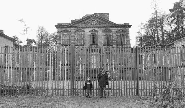
Mavisbank House in Midlothian is ruins. Mavisbank House is near Linden Place. Ⓦ.
- Building Type
- building
- Website
- https://www.mavisbank.org.uk/
Image
Beauty salons
Hairdressers
Artwork
Bookmakers
Restaurants
Bus stops
Tourist information offices
Pubs
Fast food restaurants
Newsagent's
Post offices
Roads nearby
Polton RoadPolton Road
350 m
Stevenson Place400 m
Polton Cottages400 m
The CastSpringfield Mill, Midfield House
450 m
Hoggan Way450 m
Lasswade RoadLasswade Road, Costcutter, Three Craws, Eskbank Antiques, Station Road, Haveral Wood, South Melville, Wester Melville
450 m
Braeside Road450 m
Arbuthnot Road500 m
Linden PlaceHunter Avenue
500 m
Mavisbank Grange500 m
MavisbankMavisbank
500 m
Traprain Terrace500 m
Polton Bank500 m
Hunter Court500 m
Hunter Avenue550 m
Fowler Crescent550 m
High StreetAcademy Lane, Pandora's Box, Han's Sweets'N'Eats, The Old Crown Inn, Food Lodge, Giovanni, Lord Of The Noodles, Gravity Bottleshop, Massaro's, Lambs Pend, Cavaliere, M & A Dog Grooming, Pizzeria & Fish Bar, Bonfire, Franco's, Corn Exchange, Dalkeith Parish Church, Barn, Rustic Roots, Lavender Coffee and Crumbs Café, Dalkeith, The Ship Inn, DIVA, Oxfam, VPZ, Luvely, Boots, RBS, Black & Lizars, Bank of Scotland, Superdrug, AZTel, B&M Bargains, Cancer Research UK, News Centre, The Salvation Army, Semichem, With Love, boombarbers, Bon Bon, Dalkeith Pet Store, Specsavers, Luxury Nails & Spa Dalkeith, Bonnyrigg, The Anvil Inn, Rowlands Pharmacy, High Street, Gloria's, Park Road, Mayflower, Canton, Bombay Spice, Coffee Fresco, Park Road (High Street), Greggs, Colin's, Bayne's, Hong Kong, The Old Well, Tanz Tanning, Marmaris, Gurkhas, Gordon Vets, The Storehouse, Laird & Dog, Diamodis Interiors, Laird and Dog, Luci’s Modern Italian, Lasswade, Rockville Terrace, Coop Car Park, Station Road
550 m
Polton Vale550 m
Academy Lane600 m
Mayfield CrescentHigh Street
600 m
Academy Court600 m
Harness Court650 m
Hunter Terrace650 m
Station RoadStation Road, Scotmid, Mutts Cycles, Blakes Barbers, Scotbet
700 m
Clerk StreetThe Coghorn, The Masons Arms, WHD, Clerk Street, Loanhead, Dino's, Joe's Convenience Store, Rowlands Pharmacy, One to One, Little Petals, Peony Garden, R Brown & Son, Scotbet, Scotmid, Stotties, The Forrester's Arms, New Joy, The Munch Box, The Radhuni, Traditional Turkish Barbers, Urban Beauty, Hermitage of the Transfiguraton, The Sweetie Shop, George Drive, Linglas Dental Lab, Lee Garden
700 m
The LoanMuirfield Gardens, Loanhead Post Office, The Paper Rack, George Avenue, Park Avenue, McNeil Avenue
700 m
Church StreetChurch Street, Treatz, Aim High Waxing & Beauty
700 m
Muirfield GardensMuirfield Gardens
750 m
Burghlee CrescentBurghlee Crescent
750 m
Burghlee TerraceBurghlee Terrace
800 m
Bilston Glen Viaduct800 m
Engine Road850 m
George Drive850 m
Amenities nearby
Scallywags Childrens Nursery650 m
Abandoned railways nearby
Niddrie North Junction to Bilston Glen Branch700 m
Loanhead to Glencorse Branch800 m
Buildings nearby
Former Loanhead Police Station650 m
Car dealerships nearby
Loanhead Car Sales850 m
Commercial buildings nearby
Lo Gy Centre650 m
Gardens nearby
Mavisbank Walled Garden200 m
Grasslands nearby
Mavisbank Estate350 m
Industrial areas nearby
William Hunter Coaches800 m
Military areas nearby
Loanhead Squadron Air Cadets800 m
Orchards nearby
Community Orchard450 m
Parks nearby
Fountain Green650 m
Recreation grounds nearby
Loanhead Miners Welfare Bowling Club750 m
Residential areas nearby
Blairesk Hall250 m
Rivers nearby
Bilston Burn550 m
Sports pitches nearby
Polton Bowling Club350 m
| Heritage designation | category A listed building |
|---|---|
| Located in | Midlothian, Lasswade |
| Country | United Kingdom |
 Public transport map Midlothian Legend
| Railway | |
| Bus | |
| Tram |
 Cycling map Midlothian Legend
| Cycle path | |
| Cycle lane on road | |
| Cycling on bus lane | |
| Bicycle street | |
| Cyclists allowed | |
| Cyclists allowed, good surface | |
| No cycling | |
| Cobblestones |
| Long-distance cycle route | (depending on scale) | |
| Long-distance cycle route |
 Walking map Midlothian Legend
| Path |
| Long-distance hiking trail | (depending on scale) | |
| Long-distance hiking trail | ||
| No pedestrians |