
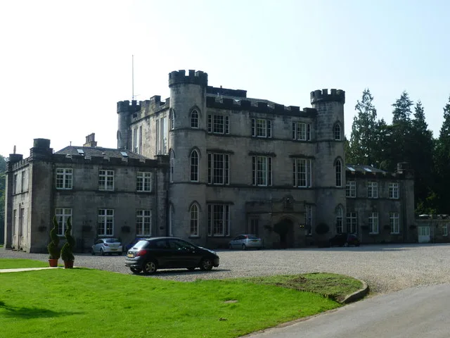
Melville Castle in Midlothian
Melville Castle in Midlothian is a hotel, Gilmerton Road (EH18 1AP). Ⓦ.
- Postal Code
- EH18 1AP
- Street
- Gilmerton Road
- Building Type
- building
- Website
- http://melvillecastle.com/
- Tourism
- hotel
Bus stops
Charging stations
Kitchen showrooms
Roads nearby
North Hill Path200 m
Melville Dykes Road Roundabout700 m
Gilmerton Road Roundabout750 m
Viscount Drive800 m
Lasswade RoadLasswade Road, Costcutter, Three Craws, Eskbank Antiques, Station Road, Haveral Wood, South Melville, Wester Melville
800 m
Captain's Gardens800 m
Melville Dykes RoadSouth Melville Farm
900 m
HillheadBroomieknowe Gardens
900 m
Elginhaugh Gardens900 m
Gilmerton Junction950 m
Melville Gate RoadMelville Gate, Melville Gate Road, King's Gate Junction
1000 m
Gilmerton RoadElginhaugh Bridge, Melville Castle, Gridserve Electric Highway High Power, Gridserve Electric Highway Medium Power Dual Charging, Dobbies Garden World
1000 m
Elm RowElm Row
1000 m
Eskfield Grove1000 m
Orchard View1000 m
Cuguen Place1000 m
Wishart Place1000 m
Viewbank View1,0 km
Baileyfield Park Drive1,0 km
Pendreich Grove1,1 km
Larkfield Road1,1 km
Beech Grove Avenue1,1 km
Martin Place1,1 km
Cortleferry Park1,1 km
City of Edinburgh BypassGilmerton Junction, Straiton Junction, Lasswade Junction
1,2 km
Sherrifhall Roundabout1,2 km
Buildings nearby
RBS Melville Gate Data Centre1,1 km
Buildings nearby
Clubhouse650 m
Lasswade Pavilion1000 m
Eco Sash & Case Workshop1,5 km
Farmyards nearby
Summerside1,2 km
Garden centres nearby
Dobbies600 m
Golf courses nearby
Melville Golf Course500 m
King's Acre Golf Driving Range600 m
Beginners Golf Course700 m
Pitch and Putt750 m
Broomieknowe Golf Course1,0 km
Hotels nearby
Premier Inn650 m
Pubs nearby
Melville Inn650 m
Residential areas nearby
Chestnut House250 m
Adam Smith House450 m
Melville Cottages650 m
Melville Grange Cottage1,0 km
Residential buildings nearby
Pittendriech800 m
Restaurants nearby
Esk Valley700 m
Elginhaugh Farm Carvery750 m
Streams nearby
Park Burn800 m
Wading Burn1,0 km
Woodlands nearby
Lugton Bogs850 m
| Heritage designation | category A listed building |
|---|---|
| Located in | Midlothian, Lasswade |
| Country | United Kingdom |
 Public transport map Midlothian Legend
| Railway | |
| Bus | |
| Tram |
 Cycling map Midlothian Legend
| Cycle path | |
| Cycle lane on road | |
| Cycling on bus lane | |
| Bicycle street | |
| Cyclists allowed | |
| Cyclists allowed, good surface | |
| No cycling | |
| Cobblestones |
| Long-distance cycle route | (depending on scale) | |
| Long-distance cycle route |
 Walking map Midlothian Legend
| Path |
| Long-distance hiking trail | (depending on scale) | |
| Long-distance hiking trail | ||
| No pedestrians |