
St Mary's in Midlothian
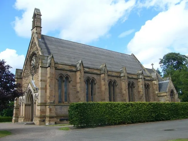
St Mary's in Midlothian is a church. It is near Shadepark Gardens and is also known as St Mary’s Chapel (Dalkeith). The church is built in the Gothic Revival style and was built in 1845. It is a listed building. St Mary's also exists in Moray, Aberdeenshire, Stirling, Glasgow City and North Ayrshire. Ⓦ.
- Amenity
- place of worship
- Building Type
- building
Image
Convenience stores
Hairdressers
Ticket shops
Tattoo studios
Fast food restaurants
Restaurants
Museum
- Dalkeith Museum (Dalkeith History Society, opening hours: Tue–Thu 11–15, web) at St Andrew Street 61 (EH22 1BP) – approx. 250 m.
Computer shops
Bus stops
Cafés
Attraction
Pet shops
Veterinary clinic
Roads nearby
Saint Mary's Court100 m
Shadepark Gardens200 m
Plummer CourtCorn Exchange
250 m
Shadepark Crescent250 m
Wheatsheaf Lane300 m
Hunt Close300 m
Lansbury Court300 m
Shadepark Drive350 m
Gibraltar GardensUSave
350 m
Duke StreetDalkeith Premier
350 m
Maxton Court350 m
High School Close350 m
Gibraltar Terrace350 m
Gibraltar Court400 m
Esk Glades400 m
Allan Terrace400 m
High StreetCavaliere, M & A Dog Grooming, Pizzeria & Fish Bar, Bonfire, Franco's, Corn Exchange, Dalkeith Parish Church, Barn, Rustic Roots, Lavender Coffee and Crumbs Café, Pandora's Box, Han's Sweets'N'Eats, The Old Crown Inn, Food Lodge, Giovanni, Lord Of The Noodles, Gravity Bottleshop, Massaro's, Lambs Pend, Dalkeith, The Ship Inn, DIVA, Oxfam, VPZ, Luvely, Boots, RBS, Black & Lizars, Bank of Scotland, Superdrug, AZTel, B&M Bargains, Cancer Research UK, News Centre, The Salvation Army, Semichem, With Love, boombarbers, Bon Bon, Dalkeith Pet Store, Specsavers, Luxury Nails & Spa Dalkeith, Bonnyrigg, The Anvil Inn, Rowlands Pharmacy, High Street, Gloria's, Park Road, Mayflower, Canton, Bombay Spice, Coffee Fresco, Park Road (High Street), Greggs, Colin's, Bayne's, Hong Kong, The Old Well, Tanz Tanning, Marmaris, Gurkhas, Gordon Vets, The Storehouse, Academy Lane, Laird & Dog, Diamodis Interiors, Laird and Dog, Luci’s Modern Italian, Lasswade, Rockville Terrace, Coop Car Park, Station Road
400 m
Tait StreetKebab Mahal, SimplyFixIt Dalkeith
450 m
St Andrew StreetFriendly, Prime Mobile, Betfred, Dalkeith Museum, Blade Barber
450 m
Musselburgh RoadThornybank, Shadepark
450 m
Brunton's ClosePete's Tattoo Studio, The BARBER Shop (Dalkeith), Baguette Express
450 m
Montagu Bridge450 m
Edinburgh RoadMarket Cross Veterinary Clinic, Bridgend Court, Queensway, Cuiken Avenue, Glencorse Barracks, Fisher's Tryst, Golf Club, Milton Bridge, Mauricewood Road, Beeslack High School, Samoa Terrace, Jade Palace, Encee
500 m
Robertson's Close500 m
White's Close550 m
Elmfield Road550 m
Gibraltar Road550 m
Pettigrew's CloseCheesecakes and Bakes, The Buccleuch, Diamonds Stitch
550 m
Normandy Drive550 m
Bill Russell Grove550 m
Bevan Lee Court550 m
Elmfield Court600 m
James Lean AvenueBevan Lee Court, James Lean Avenue, Newmills Terrace
600 m
Newmills Terrace700 m
Woodburn Drive700 m
Buildings nearby
Tickets100 m
Dalkeith House250 m
Dalkeith Masonic Hall350 m
South Esk Flow Monitoring Station400 m
Doctor's practice nearby
Dalkeith Health Centre500 m
Indoor plaies nearby
House of Fun Soft Play600 m
Motorcycle shops nearby
Motorrad Central200 m
Places of worship nearby
St Nicholas Buccleuch400 m
Pubs nearby
Coach & Horses350 m
Horseshoe550 m
Razed railways nearby
Smeaton to Monktonhall Junction Line300 m
Residential areas nearby
Bevan-Lee Court600 m
Retail areas nearby
Restoration Yard500 m
Rivers nearby
River North Esk300 m
| Named after | Mary |
|---|---|
| Inception | 1845 |
| Architectural style | Gothic Revival |
| Heritage designation | category A listed building |
| Located in | Midlothian, Dalkeith |
| Country | United Kingdom |
| Location | Dalkeith |
 Public transport map Midlothian Legend
| Railway | |
| Bus | |
| Tram |
 Cycling map Midlothian Legend
| Cycle path | |
| Cycle lane on road | |
| Cycling on bus lane | |
| Bicycle street | |
| Cyclists allowed | |
| Cyclists allowed, good surface | |
| No cycling | |
| Cobblestones |
| Long-distance cycle route | (depending on scale) | |
| Long-distance cycle route |
 Walking map Midlothian Legend
| Path |
| Long-distance hiking trail | (depending on scale) | |
| Long-distance hiking trail | ||
| No pedestrians |