
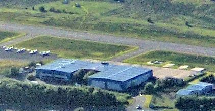
Cumbernauld Airport in North Lanarkshire
Cumbernauld Airport in North Lanarkshire is an airfield (ICAO: EGPG). Cumbernauld Airport is also known as EGPG. Ⓦ.
Bus stops
Furniture shops
Supermarkets
Restaurants
Bed shops
Car parts shops
Recycling centres
Electrical shops
DIY stores
Variety stores
Petrol stations
Interior decorators
Vending machines
Car repair shops
Roads nearby
Duncan McIntosh Road200 m
Napier Way300 m
Auchindoun Way350 m
Edenside550 m
The Links550 m
Kingsbarns Gardens600 m
Balgownie Drive600 m
St Andrews Drive650 m
Napier Park700 m
Napier Place750 m
Napier RoadWardpark, Wardpark, Napier Road opp Napier Crescent, Kelvin Wardrobes
800 m
Westerwood Roundabout800 m
Wardpark Roundabout800 m
Castlecary RoadWardpark, Castlecary Road Opp Napier Road, Wardpark, Castlecary Road opp Napier Road, Old Inns, Silk Cottage Buffet Restaurant, Wardpark, Castlecary Road opp Wyndford Road, Wardpark, Castlecary Road before Wyndford Road, Castlecary, Wardpark, Castlecary Road before Tollpark Road, Wardpark, Castlecary Road opp Tollpark Road, Castlecary, Castlecary Road opp Garnhill Farm Road, Castlecary, Castlecary Road opp Castle Court, Castlecary, Castlecary Road opp Castlecary House Hotel, Castlecary, Castlecary Road at Castlecary House Hotel, Howdens Joinery, Screwfix, Wardpark, Castlecary Road after Wardpark Roundabout, Wardpark, Castlecary Road before Wardpark Roundabout
800 m
Old Inns Roundabout850 m
Napier Court900 m
Wardpark RoadCumbernauld Wardpark Waste disposal and recycling centre
950 m
Forest RoadAbronhill Service Station
1000 m
Wardpark Court1,1 km
Dunning Drive1,1 km
Birkdale Crescent1,1 km
Wardpark Place1,1 km
Rigghead AvenueOld Inns Junction
1,1 km
Central WayCumbernauld, Glasgow Road at Roundabout at Town Centre, Cumbernauld, Central Way (Stance 1), Freedom Church, Cumbernauld, Cumbernauld, Central Way at Asda, Cumbernauld, Central Way opp Asda, Braehead Roundabout, Woman and Child, Bronze Waves, The Carrick Stone, Cumbernauld, Glasgow Road before Roundabout at Town Centre, Cumbernauld, Central Way (Stance 5), Cumbernauld, Central Way (Stance 6), Cumbernauld, Central Way (Stance 2), Cumbernauld, Central Way (Stance 3), TSB, Style City Turkish Grooming, Iceland, Cumbernauld, Central Way (Stance 4)
1,1 km
RoadsideCumbernauld Village, Turning Circle (Stop 2), Cumbernauld Village, Turning Circle (Stop 1)
1,2 km
Carnoustie Way1,2 km
The WyndGiuliano's
1,2 km
Birkdale Wood1,2 km
Muirfield Road1,3 km
Troon Gardens1,3 km
Eastfield RoadCumbernauld Village, Dullatur Road at Letham Grange, Cumbernauld Village, Dullatur Road opp Letham Grange, Cumbernauld, Eastfield Road after Carrickstone Roundabout, Cumbernauld, Eastfield Road before Carrickstone Roundabout, Meikle Drumbreck, Craigmarloch, Eastfield Road opp Primary School, Craigmarloch, Eastfield Road Near Primary School, Craigmarloch, Eastfield Road after Glen Fyne Road, Craigmarloch, Eastfield Road before Glen Fyne Road, Cumbernauld, Eastfield Road opp Carrickstone View, Cumbernauld, Eastfield Road after Dullatur Roundabout, Craiglinn, Eastfield Road after Balloch Roundabout, Craiglinn, Eastfield Road before Balloch Roundabout
1,3 km
Gleneagles Avenue1,3 km
King's View1,4 km
SmithyendsVillage Tandoori
1,4 km
King's Drive1,4 km
Turnberry Gardens1,4 km
Rosemount1,5 km
Abandoned railways nearby
Old Canal Tramway1,0 km
Body of waters nearby
Netherwood Basin950 m
Commercial buildings nearby
Heli-Air (Scotland)300 m
Phoenix Flight Training350 m
The HVDC Centre400 m
Hotels nearby
DoubleTree by Hilton Glasgow Westerwood Spa & Golf Resort750 m
Industrial areas nearby
Wardpark North550 m
Old Pit Bing1,2 km
Industrial buildings nearby
Scottish Power Technical Training - Dealain House450 m
Scottish Power Technical Training550 m
TPS600 m
Railway lines nearby
Edinburgh to Glasgow via Falkirk Line1,3 km
| Opening | 1966 |
|---|---|
| Elevation | 350 |
| Located in | North Lanarkshire |
| Country | United Kingdom |
| Website | http://www.cumbernauldairport.org/ |
| Location | Cumbernauld |
 Public transport map North Lanarkshire Legend
| Railway | |
| Bus | |
| Tram |
 Cycling map North Lanarkshire Legend
| Cycle path | |
| Cycle lane on road | |
| Cycling on bus lane | |
| Bicycle street | |
| Cyclists allowed | |
| Cyclists allowed, good surface | |
| No cycling | |
| Cobblestones |
| Long-distance cycle route | (depending on scale) | |
| Long-distance cycle route |
 Walking map North Lanarkshire Legend
| Path |
| Long-distance hiking trail | (depending on scale) | |
| Long-distance hiking trail | ||
| No pedestrians |