
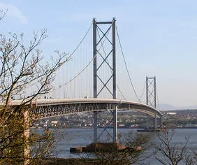
Forth Road Bridge in North Queensferry
Forth Road Bridge in Alba / Scotland, North Queensferry is a two-lane, asphalted, lit expressway. There is a one-way street. This road is part of the long-distance road "A9000". The bus lines X60, X59, FLY, 747, X56, X61, X59A, X58, X58A, X54, X52, X55 and M90 run along this road. The nearest bus stop in the vicinity is West Sands (approx. 500 m away). Ⓦ.
- Bicycle
- no
- Road Type
- expressway
- Lanes
- 2
- Speed Limit
- 50 mph
- Operator
- The Forth Road Bridge
Image
Restaurants
Drinking water fountains
Viewpoint
Post offices
Stations
- bus lines 747, FLY, M90, X52, X54, X55, X56, X58, X58A, X59, X59A, X60, X61
Tourist information
Bus stops
- bus lines 747, FLY, M90, X52, X54, X55, X56, X58, X58A, X59, X59A, X60, X61
Attraction
Café
Museum
Platforms
- bus lines 747, FLY, M90, X52, X54, X55, X56, X58, X58A, X59, X59A, X60, X61
Roads nearby
Ferry Barns Court150 m
Ferry Lane250 m
Inchcolm Drive300 m
Ferry Road300 m
Main RoadWest Sands, Willie's Well, War Memorial
400 m
Bridge View500 m
Queensferry Crossing550 m
Brock StreetNorth Queensferry Post Office
550 m
Whinneyknowe550 m
Mount Hooly Crescent550 m
West Sands550 m
Main StreetNorth Queensferry Lighthouse, Forth Bridges Light House Museum, The Wee Restaurant, Rankin's Cafe & Deli
600 m
Post Office Lane600 m
Queen Margaret's Place600 m
Chapel Place600 m
Old Kirk RoadWaterloo Well
650 m
The BraeNorth Queensferry, North Queensferry Railway Station, Travellers' Well, Lion's Head Well
650 m
Ferryhills Road650 m
Helen Place650 m
Battery RoadNorthcraig Cottage B & B, Battery Road, Battery Road Turning Circle, The Fife Pilgrim Way
700 m
Forthside Terrace750 m
Queensferry Crossing Diversion Route (northbound)750 m
Helen Lane750 m
Carlingnose Wynd750 m
Carlingnose Court750 m
Queensferry Crossing Diversion Route (southbound)800 m
Carlingnose Point800 m
Carlingnose Park800 m
Carlingnose View850 m
Abandoned railways nearby
North Queensferry Branch300 m
Aquariums nearby
Deep Sea World800 m
Bare rocks nearby
Long Craig350 m
Boatyards nearby
North Queensferry Boat Club350 m
Body of waters nearby
Battery Quarry800 m
Buildings nearby
Craig Dhu150 m
Ivy Cottage600 m
Caschillis Cottage600 m
Cemeteries nearby
St James' Chapel600 m
Community centres nearby
North Queensferry Community Centre450 m
Convenience stores nearby
Wrights Licensed Grocer650 m
Gardens nearby
Walled Garden (abandoned)350 m
Picnic site nearby
Battery Point Picnic Area900 m
Places of worship nearby
North Queensferry Parish Church700 m
Playgrounds nearby
Pierhead Play Park550 m
Railway lines nearby
Fife Circle Line650 m
East Coast (Northern) Line650 m
Residential buildings nearby
Pierhead Buildings600 m
Service buildings nearby
Queensferry Crossing North450 m
Sheds nearby
Signal House600 m
| Named after | Firth of Forth |
|---|---|
| Inception | 1964 |
| Opening | 1964 |
| Material | steel |
| Height | 44 m |
| Length | 2512 m |
| Heritage designation | category A listed building |
| Located in | Fife, City of Edinburgh, Inverkeithing, Edinburgh |
| Country | United Kingdom |
| Crosses | River Forth, Firth of Forth |
| Carries thoroughfare | A9000 road |
| Website | https://www.theforthbridges.org/ |
| Location | Edinburgh |
 Public transport map North Queensferry Legend
 | Railway | |
| Bus | |
| Tram |
 Cycling map North Queensferry Legend
 | Cycle path | |
| Cycle lane on road | |
| Cycling on bus lane | |
| Bicycle street | |
| Cyclists allowed | |
| Cyclists allowed, good surface | |
| No cycling | |
| Cobblestones |
| Long-distance cycle route | (depending on scale) | |
| Long-distance cycle route |
 Walking map North Queensferry Legend
 | Path |
| Long-distance hiking trail | (depending on scale) | |
| Long-distance hiking trail | ||
| No pedestrians |