
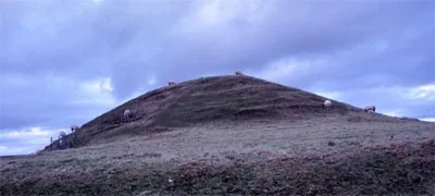
Maes Howe in Orkney
Maes Howe in Orkney Islands is an attraction. Maes Howe is also known as Maes Howe, chambered cairn. Maes Howe is near Knockhall Road. Ⓦ.
- Alternative Name
- Maeshowe
- Land Use
- grass
- Tourism
- attraction
- Wheelchair Access
- no
Image
Roads nearby
Knockhall Road700 m
Upper Twatt Road900 m
Brodgar RoadSacred Connections, Rise and Fall, Welcome to the Stones of Stenness, Brodgar Farm, Wasbister, The Ness of Brodgar, Ring of Brodgar
1,2 km
Germiston RoadGermiston Road End, Kirbister, Orkney Bed & Whisky, Tuskerbister
1,3 km
Bridge of Brodgar1,3 km
Clouston Corner1,6 km
The FidgesStenness
1,7 km
Sty Milders1,8 km
Grimeston Road1,8 km
Bigswell RoadRing of Brodnar Road End, Ring of Brodgar Road End, Bigswell
2,1 km
Ireland RoadMill of Eyrland, Mill of Ireland, Ice Cream Parlour, Stenness Post Office
2,2 km
Attraction nearby
Maeshowe Visitor Centre1,6 km
Buildings nearby
Tormiston Mill250 m
House 51,0 km
Structure 81,0 km
House 31,1 km
House 21,1 km
Mill House aka Millhouse1,5 km
Standing Stones Hotel1,9 km
Farmyards nearby
Tormiston300 m
Overbigging500 m
Quoynamoan700 m
Moa750 m
Lochside800 m
Barnhouse850 m
Quoyer1,1 km
Housequoy1,1 km
Virginia1,1 km
Lower Hobbister1,1 km
Upper Hobbister1,4 km
Hindatown Farm1,8 km
Scuan1,8 km
Anderswick1,9 km
Mid House1,9 km
West Nistaben2,1 km
North Quina2,3 km
East Nistaben2,4 km
Grasslands nearby
Barnhouse Settlement1,1 km
Places of worship nearby
Stenness Parish Church800 m
School buildings nearby
Stenness Community School1,6 km
Streams nearby
Burn of Heddle500 m
Housequoy Burn1,3 km
Muckle Burn of Stenness1,5 km
Burn of Rickla1,8 km
Burn of Russade2,2 km
Other nearby
Stenny Holm1,6 km
Baa Holm1,6 km
Long Holm1,7 km
Ling Holm2,0 km
| Area | 1 ha |
|---|---|
| Located in | Orkney Islands, Stenness |
| Country | United Kingdom |
| Part of | Heart of Neolithic Orkney |
 Public transport map Orkney Islands Legend
| Railway | |
| Bus | |
| Tram |
 Cycling map Orkney Islands Legend
| Cycle path | |
| Cycle lane on road | |
| Cycling on bus lane | |
| Bicycle street | |
| Cyclists allowed | |
| Cyclists allowed, good surface | |
| No cycling | |
| Cobblestones |
| Long-distance cycle route | (depending on scale) | |
| Long-distance cycle route |
 Walking map Orkney Islands Legend
| Path |
| Long-distance hiking trail | (depending on scale) | |
| Long-distance hiking trail | ||
| No pedestrians |