
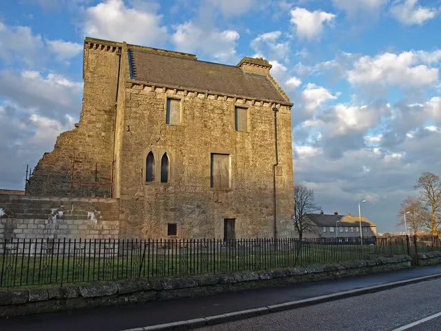
Johnstone Castle in Renfrewshire
Johnstone Castle in Renfrewshire is a castle, Tower Road (PA5 0AE). Ⓦ.
- Postal Code
- PA5 0AE
- Street
- Tower Road
- Building Type
- residential building
Image
Community centre
Bar
Butcher's
Post offices
Restaurants
Bus stops
Convenience stores
Fast food restaurants
Hairdressers
Pharmacy
Car parts shops
Roads nearby
Hawthorn Avenue50 m
Hazel AvenueHazel Arms, Day-Today, Simon's Takeaway, Avellano Hair and Beauty, Johnstone, Hazel Avenue (opp 45), Johnstone, at Birch Crescent
50 m
Tower Place50 m
Tower Road150 m
Sycamore AvenueJohnstone, after Hazel Avenue, Johnstone, opposite Hazel Avenue, Johnstone, before Elm Drive, Johnstone, Willow Drive (Near), Castle Superstore, Salwan Pharmacy, Meat at Joe's, Sycamore Avenue Post Office
150 m
Yew Place150 m
Pine CrescentJohnstone Castle Community Centre
200 m
Poplar Avenue200 m
Rowantree Road200 m
Rowantree Place200 m
Planetree Place250 m
Willow DriveJohnstone Castle
250 m
Cherry Place250 m
Ash Place250 m
Gordon Square300 m
Alder Place300 m
Birch Crescent300 m
Linn Brae350 m
Fir Place400 m
Elm DriveJohnstone, Elm Drive (at 75A), Johnstone, Elm Drive (opp 126), Johnstone, before Willow Drive, Johnstone, opp Fir Place, Johnstone, after Auchenlodment Road, Johnstone, opp Auchenlodment Road, Johnstone, opp Maple Drive, Johnstone, at Maple Drive
400 m
Broom Terrace400 m
Heather Place450 m
Quarrelton Grove450 m
Park RoadLynnhurst Hotel, Lynnhurst Bar & Restuarant, Park Avenue, Johnstone, after North Road, Johnstone, Opp North Road
450 m
Linn Park Gardens550 m
Willow Place550 m
Campbell StreetFerry Nice Food
600 m
Springfield Woods650 m
High Kirk View650 m
Beith RoadRenfrewshire, Collin's Tyres, Johnstone, opp Williamson Place, Johnstone, Williamson Place (Near), Johnstone, opp Tower Road, Johnstone, before Tower Road, A1 Motor Spares, Jackie's, Quarrelton, Spateston, opp Auchengreoch Road, Spateston, after Auchengreoch Road, Howwood, at Midton Road, Howwood, at Corseford Cottage, Howwood, opp Eliestoun Cottage, Johnstone, opposite Highcraig Avenue, Johnstone, at Cragenfeoch Avenue, Johnstone, Quarrelton Road (Near), Johnstone, Rannoch Road (Near), Johnstone High School (at), Johnstone, Craigbog Avenue (Near), Johnstone, before Woodlands Crescent, Spateston, before Hallhill Drive, Spateston, opp Hallhill Drive, Howwood, Torbracken (Near), Howwood, opp Mayfield Drive
650 m
Springfield ParkJohnstone
700 m
Rosebank Gardens700 m
Woodbank Crescent700 m
Canal Road700 m
Mavisbank Terrace700 m
Quarry StreetJohnstone Police Office, Johnstone, after Church Street
750 m
Bankside Avenue800 m
Canal Avenue800 m
Dimity Street800 m
Buildings nearby
Old Quarrelton School300 m
Johnstone Bowling Club450 m
Forests nearby
Castle Woods350 m
Parks nearby
Linn Park300 m
Places of worship nearby
Johnstone Baptist Church200 m
St. Aidan's250 m
St.Andrew's Trinity400 m
Railway lines nearby
Ayrshire Coast Line650 m
Residential buildings nearby
Linn House500 m
Streams nearby
Peockland Burn800 m
| Heritage designation | category B listed building |
|---|---|
| Located in | Renfrewshire, Johnstone |
| Country | United Kingdom |
| Described by source | Secret Scotland |
 Public transport map Renfrewshire Legend
| Railway | |
| Bus | |
| Tram |
 Cycling map Renfrewshire Legend
| Cycle path | |
| Cycle lane on road | |
| Cycling on bus lane | |
| Bicycle street | |
| Cyclists allowed | |
| Cyclists allowed, good surface | |
| No cycling | |
| Cobblestones |
| Long-distance cycle route | (depending on scale) | |
| Long-distance cycle route |
 Walking map Renfrewshire Legend
| Path |
| Long-distance hiking trail | (depending on scale) | |
| Long-distance hiking trail | ||
| No pedestrians |