
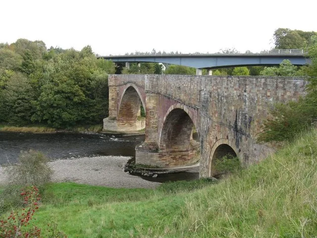
Drygrange Old Bridge in Scottish Borders
Drygrange Old Bridge in Scottish Borders is an asphalted, unlit footpath. It runs in a north-south direction and ends in a cul-de-sac. Drygrange Old Bridge is also known as Drygrange Bridge. This road is part of the bicycle routes Melrose Yellow Route and Tweed Cycleway. In the vicinity, you can find a viewpoint and a tourist information. The nearest bus stop in the vicinity is Leaderfoot Bridge (approx. 150 m away). Ⓦ.
- Bicycle
- yes
- Road Type
- footpath
- Route
- north-south
Image
Roads nearby
Leaderfoot BridgeLeaderfoot Bridge
100 m
Leaderfoot Viaduct250 m
Leader Water PathSorrowlessfield
900 m
Ravenswood RoundaboutRavenswood Roundabout
950 m
Rushbank1,1 km
Drygrange Link1,1 km
Diamond Jubilee PathLeaderfoot Lodge
1,1 km
Hazeldean Road1,1 km
Apple Tree Lane1,2 km
Townhead Way1,2 km
Big Well Wynd1,2 km
St John's Wynd1,2 km
Back Road1,2 km
Hazeldean Meadow1,3 km
Eddy Road1,3 km
Main StreetNewstead, Claymires Lane, St John's Wynd, Rushbank, The Orchard, Post Office, Coronation Garden, The Old Bakehouse, West Linton Pharmacy, West Linton Post Office, Co-op Food, Cross Keys Inn, Tak Tent in Time, Cross Keys Restaurant, West End, Reston Post Office, Reston, Trimontium - The Place of the Three (Eildon) Hills, Village Green;Kirk Yetholm, Pennine Way, End of the Pennine Way, Border Hotel, Morebattle, School, Morebattle Community Shop, Gordon, Leitholm, Cotter Lea, Leitholm Shop, Playground, Leitholm Playground, Village Hall, Sook Sook Thai Kitchen By Puy, The Plough Inn, Weirgate Brae, Jean Lawrie Court, Morrisons Daily, Mainstreet Books, Shimmer Hair Studio, St Boswells Post Office, Fry Masters, JM Quality Meats, Main Street Trading, Mainstreet Cafe, Oriental, Trends, Copperpot Interiors, Kirk Yetholm, Springfield Terrace, The Glebe, Gordon Arms Hotel, Heiton, Ladyrig Road Junction, Ladyrig View, Sunlaws Road Junction, Goldilands B&B, Borders Gunroom, Stichill, Wellfield, War Memorial, Swinton, The Green
1,3 km
Claymires Lane1,4 km
The OrchardReston Station, Paxton
1,5 km
Dean RoadSprouston, Priorswalk, Dean Place, Dean Park, Sprouston Village Green
1,6 km
Old A68 Link1,8 km
Abandoned railways nearby
Edinburgh to Carlisle Line700 m
St. Boswells & Reston2,0 km
Buildings nearby
Tweedswood400 m
Tweed Forum & Tweed Foundation1000 m
Community centres nearby
Redpath Village Hall1,2 km
Farmyards nearby
Leaderfoot200 m
Broomhill650 m
Gledswood1,2 km
Drygrange Mains1,3 km
Kittyfield1,4 km
Halidean Mill1,7 km
Forests nearby
Moss Plantation350 m
Camp Plantation800 m
Bog Plantation1,0 km
Juniperbank Plantation1,1 km
Covert Plantation1,5 km
Hill Plantation1,5 km
Nursing homes nearby
Drygrange Hall900 m
Playgrounds nearby
Newstead Playpark1,1 km
Residential areas nearby
Oakendean House1,7 km
Residential buildings nearby
West Lodge1000 m
East Lodge1,6 km
Scrublands nearby
The Yiddy1,3 km
Streams nearby
Bogle Burn1,3 km
Huntly Burn1,6 km
Hallidean Burn1,6 km
Viewpoint nearby
Trimontium viewing platform250 m
Woodlands nearby
Tweed Wood250 m
Redpath Dean1,9 km
| Inception | 1779 |
|---|---|
| Heritage designation | category A listed building |
| Located in | Scottish Borders, Melrose |
| Country | United Kingdom |
| Crosses | River Tweed |
| Carries thoroughfare | footpath, road |
 Public transport map Scottish Borders Legend
| Railway | |
| Bus | |
| Tram |
 Cycling map Scottish Borders Legend
| Cycle path | |
| Cycle lane on road | |
| Cycling on bus lane | |
| Bicycle street | |
| Cyclists allowed | |
| Cyclists allowed, good surface | |
| No cycling | |
| Cobblestones |
| Long-distance cycle route | (depending on scale) | |
| Long-distance cycle route |
 Walking map Scottish Borders Legend
| Path |
| Long-distance hiking trail | (depending on scale) | |
| Long-distance hiking trail | ||
| No pedestrians |