
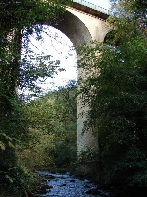
Cartland Bridge in South Lanarkshire
Cartland Bridge in South Lanarkshire is a two-lane, unlit main road and it crosses a bridge and it ends at Lanark Road. This road is part of the long-distance road "A73". Ⓦ.
- Road Type
- main road
- Lanes
- 2
- Speed Limit
- 40 mph
- Route
- east-west
Bus stops
Roads nearby
Sunnyside Road250 m
Mouse Brig300 m
Sycamore Grove350 m
Lanark RoadLeshmahagow Road, Crossford, Holm Road, Smugglers Brig Road, Braidwood Road, Crossford Post Office, Tillietudlem Hotel, Crossford Garage, Jenny's Cakes Ltd, Ravenstruther, Westbank Terrace, Silvermuir Road, Ayr Road, Milton Road, Goremire Road, Smugglers Bridge, Upper Cairnie, Craig Cottage, Silverbirch Garden Centre, The Buttery, 212 Lanark Road, Hazelbank, Orchardville, Auchenheath, Lancaster Avenue, Shieldhill Road, Tesco, Rosebank, Flower Of Scotland Garden Centre, Popinjay Hotel, Shelley Road, Shelley road, Carstairs, At Rosemount Crescent On Lanark Road, Carstairs, Opposite Rosemount Crescent On Lanark Road
400 m
Cedar Grove400 m
Mousemill Road400 m
The Ditches450 m
Ashcroft450 m
Kirkfieldbank Brae600 m
Kirkfield Road600 m
Riverside Road22 Riverside Road, 36 Riverside Road, 94 Riverside Road, House number 116, Linnville, Kirkfieldbank Road, Kirkfieldbank, 149 Riverside Road, Grays Close
600 m
Hillhouse Farm Gate650 m
Clydesholm Court650 m
Lockhart Avenue700 m
Kairnhill Court700 m
West Nemphlar Road700 m
Ramoth750 m
Hillhouse Farm Road750 m
Clydesholm Brae800 m
Howacre800 m
Lockhart Drive800 m
Cartland View800 m
Nemphlat Hill800 m
Glasgow RoadWellbrae, Overton Avenue, Avondale Street, Brook Street, Woodhill Road, New Edinburgh Road, Belmont Avenue, Park Road, Western Avenue, Southcroft Road, Quay Road, Park Burn Court, Parkville Drive, Whistleberry Road, Thornhill Avenue, The Parkville, Dukes Road, Cairnmuir Road, Millcroft Road, Shawfield, Nerston, Greenlees Road, Coatshill Avenue, Cowan Wilson Avenue, Divito's, Buchanan Drive, Salvation Army, Bothwell Street, Kingsgate Retail Park, Glenlee Street, Sneddon Street, Greenfield Road, Victoria Street, Blantyre Sports Centre, Asda Café, Blantyre Library, Timpson, Priory Street, The Old Original Bar, Blantyre, Stonefield Road, Blantyre Post Office, The Co-operative Funeralcare, Londis, Agnew's, Strachan Craft Butchers, St Andrew's Hospice, Sun House Chineese Takeaway, Sun Off Sales, Cosmic Cherubs, Spice of Life, William Hill, Rowlands Pharmacy, Ladbrokes
900 m
Staikhill900 m
Park Drive900 m
Whitehill Terrace900 m
Shields Loan950 m
Park PlaceWhitehill Crescent, Mousebank Road
950 m
Grange Court1000 m
Mousebank Road1000 m
Mousebank Lane1000 m
Mouse Bridge1000 m
Ridgepark Drive1000 m
Wheatlandside1,0 km
Springfield Gardens1,0 km
Wheatland Drive1,0 km
Scarletmuir1,1 km
Stey Brae1,1 km
Waterloo Drive1,1 km
Body of waters nearby
Mouse Water100 m
Brownfields nearby
FormerRidgepark School950 m
Buildings nearby
Craig Cottage150 m
Orchard Dell200 m
Mouse Mill250 m
Mousemill House350 m
Caravan site nearby
Clyde Valley Caravan Park550 m
Nature reserves nearby
Cartland Crags - Clyde Valley Woodlands NNR750 m
Streams nearby
Woodend Burn1,0 km
| Heritage designation | category B listed building |
|---|---|
| Located in | South Lanarkshire, Lanark |
| Country | United Kingdom |
| Crosses | Mouse Water |
| Carries thoroughfare | A73 road |
 Public transport map South Lanarkshire Legend
| Railway | |
| Bus | |
| Tram |
 Cycling map South Lanarkshire Legend
| Cycle path | |
| Cycle lane on road | |
| Cycling on bus lane | |
| Bicycle street | |
| Cyclists allowed | |
| Cyclists allowed, good surface | |
| No cycling | |
| Cobblestones |
| Long-distance cycle route | (depending on scale) | |
| Long-distance cycle route |
 Walking map South Lanarkshire Legend
| Path |
| Long-distance hiking trail | (depending on scale) | |
| Long-distance hiking trail | ||
| No pedestrians |