
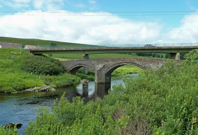
Clyde's Bridge in South Lanarkshire
Clyde's Bridge in South Lanarkshire is a track. It runs in an east-west direction and ends in a cul-de-sac. Clyde's Bridge is also known as Wandel, Clyde's Bridge. Ⓦ.
- Bicycle
- yes
- Road Type
- track
- Route
- east-west
Image
Newsagent's
Tourist information offices
Fire station
Hotels
Pubs
Viewpoint
Bus stops
Fast food restaurants
Charging stations
Cafés
Convenience stores
Attraction
Museum
- Crawfordjohn Heritage Venture (web) – approx. 6,8 km.
Specialist shops
Places of worship
Roads nearby
Bridgend Road400 m
Duneatonfoot Bridge950 m
Howgate RoadHowgate Road, Roberton
1,9 km
Toll Bridge2,0 km
Welcome Break Abington ServicesAbington Interchange, Abington Supercharger
2,2 km
Nap Bridge2,4 km
Craighead Road3,0 km
Edinburgh RoadCross Road, Leafield Road
3,2 km
Colebrooke Terrace3,4 km
Carlisle RoadAbington General Stores, Abington, Old Avon Road, Merrton Road, Cairnhouses, Crawford, Bellstane Avenue, Angus Avenue, The Milano Bar, Barncluith, Birks Road, Borland Drive, Robert Smillie Crescent, Middleton Avenue, Shaws Road, John Place, Glenavon Pub, Lidl, Kirkmuirhill Parish Church, JET, Lochanbank Drive, Park Street, Chatelherault Inn, Chatelherault Country Park, Isabella Gardens, Avon Bridge, Millennium Milepost Coalburn, Canderside Toll, Draffan Road, Fyne Crescent
3,4 km
Hunters CourtHunters Court
3,4 km
Murdostoun Place3,5 km
Station RoadAbington Fire Station, Oakbank, Uddingston, Skinny coffee house, Smith's, Viewfield Avenue, Anderson Gardens, Village Bar, Aspire Convenience Store, Armac Vets, Lesmahagow Police Station, Park Lane, Stonefield Park Gardens, Stance 1, Hamilton Central, The World Fountain, David Livingstone Shop, Nad's Store, Law Junction, Muirhead Drive, Buchanan Drive, Brackenhill Road, Shawfield Crescent, Law Post Office, J & H Cairns, Carluke
3,5 km
Hainings Wynd3,5 km
Glengonnar Crescent3,7 km
Old Roman Road3,9 km
Leadhills Road4,8 km
Lay By4,9 km
Millrigg Road5,3 km
The SteadingsWiston
5,4 km
Buildings nearby
Wandle House800 m
Abington Hall3,3 km
Reception3,5 km
Caravan site nearby
Mount View Caravan Park3,6 km
Community centres nearby
Roberton Village Hall2,0 km
Convenience stores nearby
Welcome Break2,0 km
Farmyards nearby
Littlegill700 m
Woodend Farm1,6 km
Cold Chapel2,1 km
Nether Abington2,6 km
Craighead4,1 km
Newton4,9 km
Forests nearby
Southwood Plantation3,6 km
Tewsgill Wood4,2 km
Hotels nearby
Days Inn2,0 km
Petrol stations nearby
HGV2,1 km
Places of worship nearby
Upper Clyde Parish Church3,4 km
Residential areas nearby
Kilpotlees2,6 km
Restaurants nearby
The Good Breakfast2,0 km
Rivers nearby
Duneaton Water2,1 km
River Clyde2,3 km
School buildings nearby
Abington Primary School3,2 km
Streams nearby
Wandel Burn1,3 km
Coldchapel Burn2,1 km
Roberton Burn2,8 km
Star Burn3,8 km
Glengonnar Water4,5 km
Garf Water5,3 km
Woodlands nearby
Castlehill Strip5,4 km
| Heritage designation | category B listed building |
|---|---|
| Located in | South Lanarkshire, Wiston |
| Country | United Kingdom |
| Crosses | River Clyde |
| Carries thoroughfare | farm road, A702 road |
 Public transport map South Lanarkshire Legend
| Railway | |
| Bus | |
| Tram |
 Cycling map South Lanarkshire Legend
| Cycle path | |
| Cycle lane on road | |
| Cycling on bus lane | |
| Bicycle street | |
| Cyclists allowed | |
| Cyclists allowed, good surface | |
| No cycling | |
| Cobblestones |
| Long-distance cycle route | (depending on scale) | |
| Long-distance cycle route |
 Walking map South Lanarkshire Legend
| Path |
| Long-distance hiking trail | (depending on scale) | |
| Long-distance hiking trail | ||
| No pedestrians |