
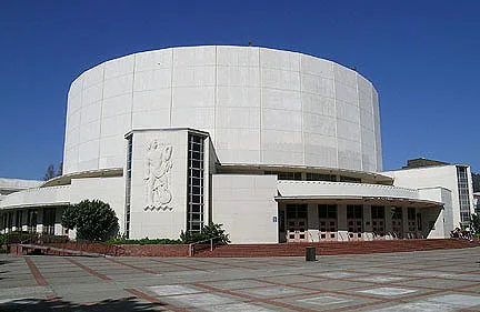
Berkeley Community Theater in Berkeley, California
Berkeley Community Theater in Berkeley is a theater (Berkeley High School), Allston Way 1930 (94704) 🌐. Berkeley Community Theater is also known as A Building. Ⓦ.
- House Number
- 1930
- Postal Code
- 94704
- Street
- Allston Way
- Alternate Name
- A Building
- Amenity
- theater
- Building Type
- theater
- Operator
- Berkeley High School
- Website
- https://theaters.berkeleyschools.net/
Image
Car rentals
Parking entrances
ATMs
Cafes
Tourist information centers
Bike rentals
Parking lots
Museums
- Berkeley Historical Society (Web) at Center Street 1931 – approx. 0.1 mi.
Theaters
Bus stops
Kindergartens
Hostels
Colleges
Streets nearby
Harold WayDharma College, Armstrong College Building
0.1 mi
Durant AvenueInstitute of Buddhist Studies, Durant Avenue & Shattuck Avenue, Beta Lounge, U.S. Bank, Toyota, Cornerstone Craft Beer & Live Music, Durant Avenue & Dana Street, Durant Avenue & Telegraph Avenue, Durant Avenue & Ellsworth Street, Free Library, Durant Avenue & College Avenue, Christian Science Organization at the University, Bank of America, Gypsy's Trattoria Italiano, King Pin Donuts, Sweetheart Cafe, Thai Basil, Cafe Durant, Kimchi Garden, D'yar, L'Gusto, Boba Ninja, Myungrang Hotdogs, Steve's Korean B.B.Q., Punjabi Dhaba Indian Eatery, Bears Ramen House, Katsumi Sushi, I.B.'s, Johnston's Market, Dumpling Kitchen, Riceful, Yogurt Park, KoStop, Kip's Bar and Grill, Fun Park, Bear basics, Cafe 3, Bear Market, Artichoke Basille's Pizza, Henry's, Top Dog, Super Duper Burger, La Burrita, Bunz, Games of Berkeley, Binge Coffee House, Taco Bell Cantina, Jaguar Karaoke, Seniore's Pizza, Tap Haus, BluPeak credit union, Hustead's Auto Body, Chase
0.3 mi
Dwight WayDwight Way & Martin Luther King Junior Way, Dwight Way & Milvia Street, Milvia Parking Lot, Dwight Way & Prospect Street, Dwight Way & 9th Street, Warring Street & Piedmont Crescent, !ndustr!al, Way Station Brew, Musashi, Dwight Way & Fulton Street, Berkeley Plumbing Co., Nang Sida Thai Yoga Massage, Herrick Campus, Dwight Way & 6th Street, Shattuck Avenue & Dwight Way, Homemade Cafe, Annaher Grocery & Liquor, Dwight Way & San Pablo Avenue, Dwight Way & Curtis Street, Dwight Way & Mathews Street, Dwight Way & Bonar Street, Dwight Way & Mabel Street, Dwight Way & Valley Street, Dwight Way & Sacramento Street, BiRite Liquor, Wash & Shop Laundromat, Nana Thaï bistro, The Book House, Dwight Way & McGee Avenue, Dwight Way & Grant Street, Hellywelly atelier, Piedmont Crescent & Dwight Way, Bongo Burger, Romeo's Coffee, Dwight Way & 7th Street, Anchalee, AVS, B League Vintage clothes and records
0.3 mi
Fulton StreetHui Lau Shan, D. King Gallery, Gold Bean Cafe, Stadium Apartments Leasing Office, Berkeley Shambhala Center
0.3 mi
Haste StreetBerkeley Dog and Cat Hospital, Shattuck Market, Parking Directory, Haste Street & Shattuck Avenue, Qahwa Time, Berkeley Piano Club, Haste Street & Milvia Street, McKinley Hall, Chess Club, Sourdough & Co
0.4 mi
Milvia StreetThe Poetry Garden, 1st United Credit Union, Downtown Berkeley YMCA Hotel, Nuha's Cafe, Berkeley Ace Hardware, Budget, Avis
0.4 mi
Buildings nearby
Corder Building0.2 mi
Stadium Place0.3 mi
Manville Hall0.3 mi
Chan Building0.3 mi
Fine Arts Building0.4 mi
The Dwight0.4 mi
Apartment buildings nearby
Stuart Pratt Manor0.2 mi
Varsity Berkeley0.2 mi
Channing Poolside Apartments0.2 mi
Channing Place0.2 mi
The Lair0.3 mi
Rapa Nui0.4 mi
The Blake0.4 mi
Buildings nearby
Mangalam Research Center for Buddhist Languages0.1 mi
Berkeley Conference Center0.2 mi
AT&T0.3 mi
Banway Building0.3 mi
URSA0.3 mi
The Rajkumar0.3 mi
The Grassroots House0.4 mi
Colleges nearby
New College Berkeley0.2 mi
Construction sites nearby
Berkeley Plaza0.2 mi
IDENTITY Logan Park0.3 mi
Doctor's offices nearby
Sutter Urgent Care - Berkeley0.3 mi
Grasslands nearby
Campus Green300 ft
Libraries nearby
Central Branch Berkeley Public Library0.2 mi
Motels nearby
Downtown Berkeley Inn0.1 mi
Places of worship nearby
Jodo Shinshu Center0.3 mi
Berkeley Buddhist Temple0.3 mi
Post offices nearby
Berkeley Main Post Office0.1 mi
Residential areas nearby
K Street Flats0.1 mi
IDENTITY Logan Park Apartments0.3 mi
Restaurants nearby
Sushinista500 ft
School buildings nearby
C Building250 ft
D Building350 ft
G Building350 ft
E Building350 ft
M Building0.1 mi
Social facilities nearby
The Ivy0.3 mi
Sports centers nearby
Donahue Gym450 ft
Stadiums nearby
Jacket Stadium0.2 mi
Train stations nearby
Downtown Berkeley0.2 mi
Warehouses nearby
timberline geodesics0.4 mi
| Year built | 1950 |
|---|---|
| Located in | Berkeley |
| Country | United States |
| Part of | Berkeley High School, Berkeley High School Campus Historic District, Berkeley Historic Civic Center District |
 Public transit map Berkeley Legend
| Railway | |
| Bus | |
| Streetcar |
 Bicycle map Berkeley Legend
| Bike path | |
| Bike lane on roadway | |
| Cycling allowed on bus lane | |
| Bicycle street | |
| Open to cyclists | |
| Open to cyclists, good path | |
| Cycling prohibited | |
| Cobblestone |
| Long-distance bike route | (depending on scale) | |
| Long-distance bike route |
 Pedestrian map Berkeley Legend
| Path |
| Long-distance hiking trail | (depending on scale) | |
| Long-distance hiking trail | ||
| Pedestrians prohibited |