
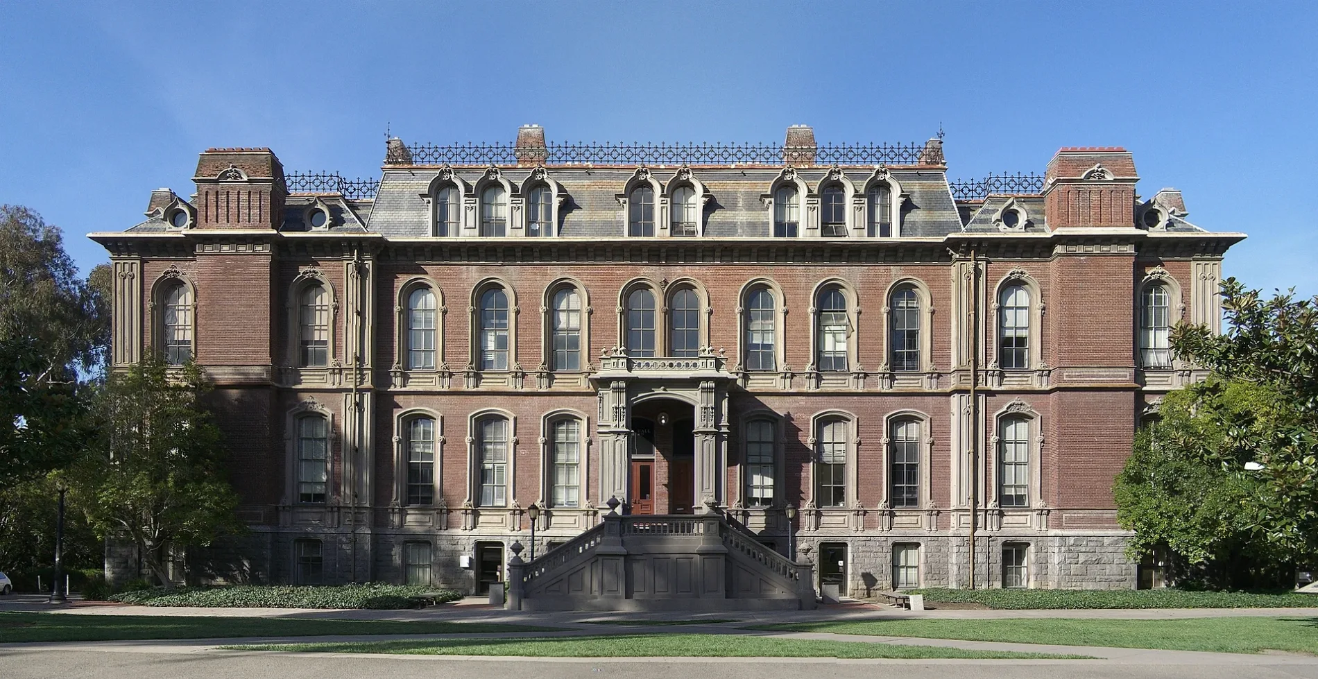
South Hall in Berkeley, California
South Hall in Berkeley is a university building. South Hall is also known as School of Information. South Hall is located near Eshleman Road. South Hall is built in the Second Empire architecture in the United States and Canada style. South Hall also exists in Ventura County. Ⓦ.
- Alternate Name
- School of Information
- Building Type
- university building
Image
Fountains
Attractions
Fast food restaurants
ATMs
Artworks
Libraries
Art galleries
Theaters
Streets nearby
South Hall RoadStill Life and Blossoming Almond Trees, Apples from Heaven: The Armenian Alphabet
250 ft
The Class of 1925 CourtyardInstitute of Governmental Studies Library, Howison Philosophy Library, The Bosphorus
250 ft
South DriveInterior Forge, Ethnic Studies Library, Pappy Waldorf, The Last Dryad, Albert Einstein 1879-1955
250 ft
Barrow LaneUniversity of California Police Department
350 ft
Eshleman Road500 ft
Dwinelle PlazaDurham Studio Theater
0.1 mi
University Drive4.0 Ball, Main Stacks, Moffitt Library, Earth Sciences and Map Library, Smilodon
0.1 mi
Savio StepsUC Berkeley Visitor Center
0.1 mi
Sproul PlazaLudwig's Fountain, Equator Coffee, Amazon Locker, Student Union Piano
0.1 mi
Cesar Chavez PatioBank of America, Golden Bear Cafe, Grizzly Bear, Berkeley Art Studio
0.1 mi
Oppenheimer WayPhysics-Astronomy Library
0.2 mi
Bowditch StreetCrossroads, Peet's Coffee, The Den, Dumpling Express, Chengdu Style Restaurant
0.2 mi
Ong & Ong PlazaLocal X Design, Bill's Beach
0.2 mi
Bancroft WayBancroft Way & College Avenue, Bancroft Way & Bowditch Street, Franklin Bros Market, Congregation Beth Israel, Bancroft Center of Chinese Medicine, AmphitheaterLAB, Timbre, Bancroft Way & Telegraph Avenue, Bancroft Way & Piedmont Avenue, Bancroft Way & Shattuck Avenue, Bancroft Way & Ellsworth Street, Poets Corner, Bancroft Way & Dana Street, Mechanics Bank, Great China, Class of 1914 Fountain, Berkeley Law Library, Caffé Strada, University YWCA, Headland's Brewing, Cal Student Store, Sather Gate, Take Eat Easy, Cafe Milano, Bancroft Clothing, Chase, Yi Fang Tea, Nippon Curry, Panda Express, Insomnia Cookies, Fall Rush, RareTea, UC Hair Salon, World Cuts, Stiles Hall, Chicha San Chen, Berkeley Student Food Collective, Crumbl Cookies, Momo House, Campus Dental Center, Binge Coffee House, California Center for Innovative Transportation, Paisley Vintage, Foster Coin and Publishing, Wonderful Spa, Anthropology Library
0.2 mi
Apartment buildings nearby
Hub Bancroft0.2 mi
Attractions nearby
Sather Tower400 ft
Buildings nearby
Moses Hall150 ft
Old Art Gallery200 ft
Anthony Hall250 ft
Architects & Engineers400 ft
Durant Hall500 ft
César E. Chavez Student Center0.1 mi
The Standard0.2 mi
Construction sites nearby
Bancroft Parking Structure Replacement0.2 mi
Food courts nearby
Durant Food Court0.2 mi
Grasslands nearby
Faculty Glade500 ft
Libraries nearby
Bancroft Library450 ft
Doe Memorial Library500 ft
Hargrove Music Library0.1 mi
Museums nearby
Bakar BioEnginuity Hub0.2 mi
Post offices nearby
United States Post Office0.2 mi
Recreation grounds nearby
North Field0.1 mi
Streams nearby
Strawberry Creek400 ft
University buildings nearby
Wheeler Hall300 ft
Stephens Hall350 ft
Birge Hall500 ft
Morrison Hall0.1 mi
Physics North & Physics South0.1 mi
Sproul Hall0.1 mi
Campbell Hall0.1 mi
Hertz Hall0.1 mi
Hearst Field Annex0.1 mi
Gilman Hall0.2 mi
Giauque Hall0.2 mi
Faculty Club0.2 mi
Senior Hall0.2 mi
Hildebrand Hall0.2 mi
Anthropology and Art Practice Building0.2 mi
Other nearby
Doe Traverse500 ft
| Year built | 1873 |
|---|---|
| Architectural style | Second Empire architecture in the United States and Canada |
| Heritage designation | National Register of Historic Places listed place |
| Located in | Berkeley |
| Country | United States |
| Location | University of California, Berkeley |
 Public transit map Berkeley Legend
| Railway | |
| Bus | |
| Streetcar |
 Bicycle map Berkeley Legend
| Bike path | |
| Bike lane on roadway | |
| Cycling allowed on bus lane | |
| Bicycle street | |
| Open to cyclists | |
| Open to cyclists, good path | |
| Cycling prohibited | |
| Cobblestone |
| Long-distance bike route | (depending on scale) | |
| Long-distance bike route |
 Pedestrian map Berkeley Legend
| Path |
| Long-distance hiking trail | (depending on scale) | |
| Long-distance hiking trail | ||
| Pedestrians prohibited |