
Battery Chamberlin in San Francisco
Battery Chamberlin in San Francisco is a ruin (built in 1904), Battery Chamberlin Road 1621. Battery Chamberlin is also known as Six-Inch Rifled Gun No. 9. Ⓦ.
- House Number
- 1621
- Street
- Battery Chamberlin Road
- Building Type
- bunker
Image
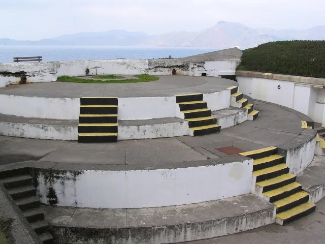
Streets nearby
North Van Horn Lane0.1 mi
South Van Horn Lane0.2 mi
Weston Court0.2 mi
Bell Court0.2 mi
Battery Chamberlin Road0.2 mi
Bowley StreetBowley Street & Lincoln Boulevard, Baker Beach Parking Lot
0.2 mi
Schofield Court0.2 mi
Barry Court0.2 mi
Treat Lane0.2 mi
Wright Court0.2 mi
Stilwell Road0.2 mi
Bliss Court0.2 mi
Sand Ladder0.2 mi
Beale StreetBay Wheels, Tahoe Convoy, Joe & The Juice, Philz Coffee, Beale Street & Mission Street, Mendocino Farms, Salesforce Transit Center Bay 35, Salesforce Transit Center Bay 36, Coca-Cola, Beale Street & Folsom Street, Beale Street & Howard Street, StoragePRO, Spring Fertility
0.2 mi
Hitchcock Lane0.2 mi
Craig Court0.2 mi
Gibson Road0.2 mi
Smith Lane0.2 mi
Soule Lane0.2 mi
McNair Court0.2 mi
Baker Court0.3 mi
Brooks Street0.3 mi
Pershing DrivePershing Drive & Kearny Lane, Pershing Drive & Stilwell Road
0.3 mi
Murray Lane0.3 mi
Sibert Lane0.3 mi
Seawell Lane0.3 mi
Peek Lane0.3 mi
Batteries to Bluffs Trail0.3 mi
Washington BoulevardImmigrant Point Overlook, 410 Washington Boulevard, 407 Washington Boulevard, Washington Boulevard & Deems Road, Washington Boulevard & Battery Caulfield Road
0.3 mi
McRae Lane0.3 mi
Johnstone DriveGlobaltap
0.3 mi
Lincoln BoulevardLincoln Boulevard & Pershing Drive, Bay Wheels, Lincoln Boulevard & Lendrum Court, Brightworks School, Pilot's Row, Lincoln Boulevard & Storey Avenue, Presidio Community YMCA, Lincoln Boulevard & Girard Road
0.3 mi
Moore Lane0.3 mi
North Hughes Lane0.3 mi
Merriam Lane0.3 mi
Miles Court0.3 mi
Kearny Lane0.3 mi
South Hughes Lane0.3 mi
Coastal TrailPort of San Francisco (info board), The Golden Gate (info board), Lands End (info board), Pacific Overlook, Eagles Point Overlook, Exploring Lands End, Lands End Trail Eagles Point, 916 El Camino Del Mar, San Francisco, CA 94121, USA, Gateway to Lands End, Battery West, Golden Gate Overlook, The Presidio: Coastal Trail (GGNRA), Golden Gate Bridge overlook, Protecting the Coast: Army’s presence lingers (GGNRA), Navigating the Golden Gate
0.3 mi
25th Avenue North0.4 mi
El Camino del MarLincoln Boulevard & Bowley Street, Legion of Honor Café, Legion of Honor Gift Shop, “City Cemetery: A Forgotten Graveyard”
0.4 mi
Sea Cliff AvenueChina Beach Entrance
0.4 mi
Howard RoadLobos Valley Trailhead
0.4 mi
Lobos Creek Valley Trail0.4 mi
25th AvenueLa Petite Rose, 25th Avenue & Lake Street, 25th Avenue & El Camino Del Mar, Sunset Communal Arts, 25th Avenue & Geary Boulevard, 25th Avenue & Clement Street, 25th Avenue & Balboa Street, 25th Avenue & California Street, 25th Avenue & Fulton Street
0.4 mi
Buildings nearby
Water Treatment Plant0.3 mi
Battery Crosby0.3 mi
Streams nearby
Coyote Gulch0.3 mi
Lobos Creek0.3 mi
| Heritage designation | National Register of Historic Places listed place |
|---|---|
| Protected area | Golden Gate National Recreation Area |
| Located in | San Francisco |
| Country | United States |
| Described by | FortWiki |
| Location | Presidio of San Francisco |
 Public transit map San Francisco Legend
| Railway | |
| Bus | |
| Streetcar |
 Bicycle map San Francisco Legend
| Bike path | |
| Bike lane on roadway | |
| Cycling allowed on bus lane | |
| Bicycle street | |
| Open to cyclists | |
| Open to cyclists, good path | |
| Cycling prohibited | |
| Cobblestone |
| Long-distance bike route | (depending on scale) | |
| Long-distance bike route |
 Pedestrian map San Francisco Legend
| Path |
| Long-distance hiking trail | (depending on scale) | |
| Long-distance hiking trail | ||
| Pedestrians prohibited |