
Bottom of the Hill in San Francisco
Bottom of the Hill in San Francisco is a bar, 17th Street 1233 (94107) 🌐. Ⓦ.
- House Number
- 1233
- Postal Code
- 94107
- Street
- 17th Street
- Amenity
- bar
- Building Type
- building
- Website
- http://www.bottomofthehill.com/
Image
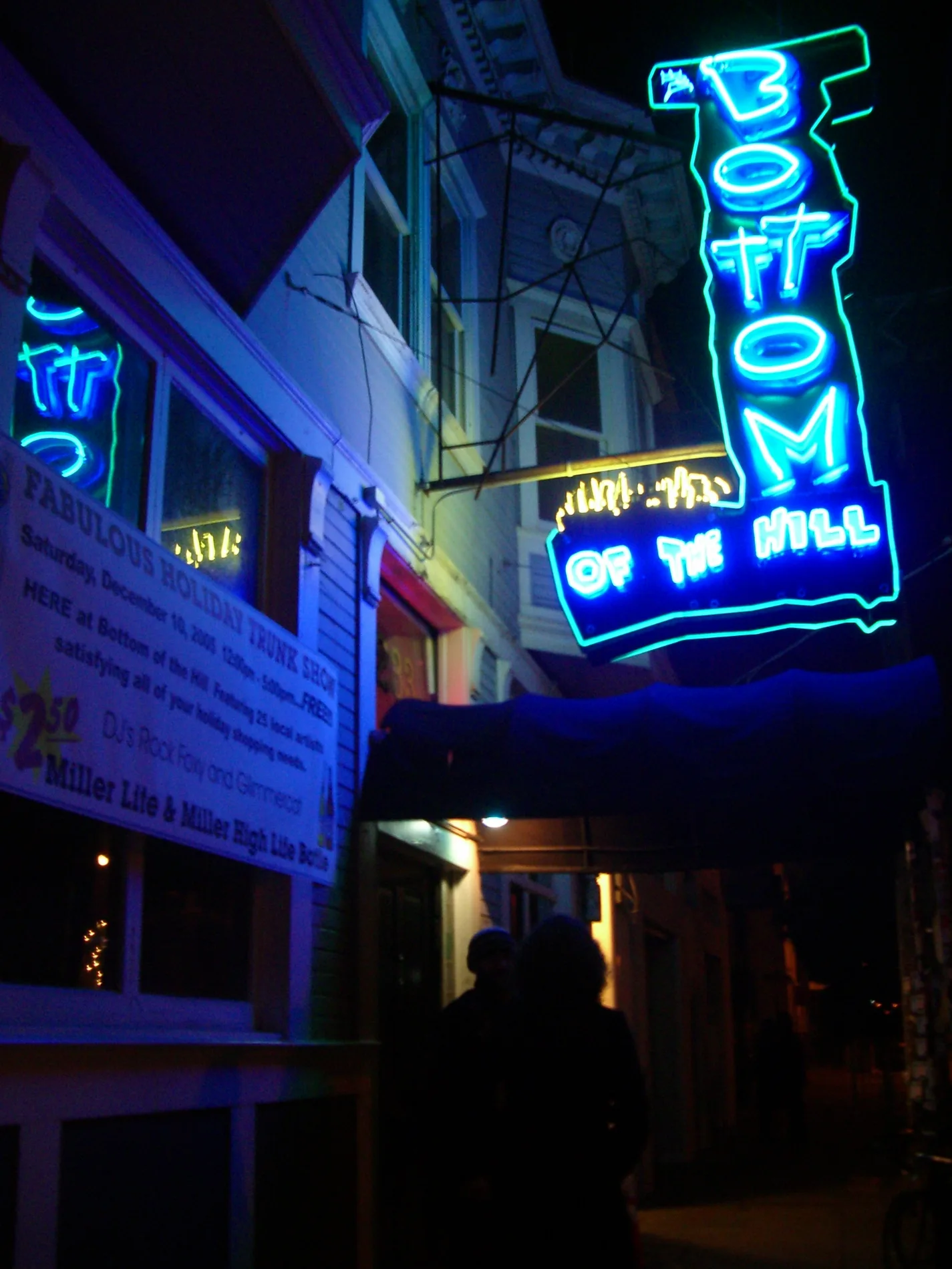
Streets nearby
17th StreetSmog Queen, Eureka Market, Live Sushi Bar, Kansas Street & 17th Street, Food Mart, Spro, JB's, Thee Parkside, La Lucha, ARCH Art Supplies, Clayroom, 17th Street & Belvedere Street, 17th Street & Diamond Street, 76, Two Sons Sandwiches, Steep Brew, Rhode Island Street & 17th Street, Next Level Burger, 17th Street & De Haro Street, Potrero Cleaners & Alterations, El Toro, 17th Street & Clayton Street, Adel's Wine Cellar, 17th Street & Cole Street, Saucy Asian, Wash & Dry Launderland, Psychic Reader, C& H Complete Auto Repair, La Mission Market, Aaha Indian Cuisine, Autobody Spa, 17th Street & Kansas Street, Philz Coffee, Milkbomb, Potrero Hill Montessori, Lutz Bath & Kitchen, Robin's Cafe, Maxfield's House of Caffeine, Cornerstone SF Church, Guerrero Launderette, Morning Due Café, Pizza Due, New Deal Home, Suchada, Project Commotion, Andytown Coffee Roasters, Vista Point, Rite Spot Cafe
200 ft
Daggett StreetStreet Taco
0.1 mi
Mississippi StreetAuthentic 415
0.1 mi
Pennsylvania AvenuePennsylvania Avenue & 25th Street, Dogpatch Biofuels, Pennsylvania Avenue & 23rd Street, Pennsylvania Avenue & 20th Street
0.1 mi
7th StreetBay Wheels, Michael Thompson Framing, 7th Street & Mission Street, 7th Street & Brannan Street, SF City Clinic, Rumors Sports Lounge, 7th Street & Harrison Street, The Bento Guys, Alameda Electrical Distributors, California Service Tool, Sightglass Coffee, West SoMa, 7th Street & Howard Street, Hairetics Salon, Bearing Agencies Inc., 7th Street & Market Street, YOTEL San Francisco, Teo Restaurant & Bar, 7th Street & Bryant Street, 7th Street & Folsom Street, Celia's In 'N Out Cleaners, Tony Baloney's Market, West Bay Pilipino Multi-Service Center
0.2 mi
Hubbell Street0.2 mi
Southern Embarcadero FreewayKaiser Mission Bay Pharmacy, Jerrold Avenue & Selby Street
0.2 mi
C Street0.2 mi
Irwin StreetSimpson Library, Economy Restaurant Fixtures
0.2 mi
Campus Way0.3 mi
Hospital StreetBay Wheels
0.3 mi
Roger Evans TerraceCampus Police Office
0.3 mi
Merrimac StreetThe Pub, Mission Bay Conference Center at UCSF, Chase
0.3 mi
Owens StreetThe Venue, UCSF Hand Center, Owens Street & Gene Friend Way, Esposto's, Starbucks
0.3 mi
Long Bridge StreetCafe Réveille, Mattress Firm, Joe & The Juice, Long Bridge Street & El Dorado Street
0.3 mi
Mission Bay Boulevard0.4 mi
Gene Friend WaySubway, Publico, Peasant Pies, Double Shot Coffee
0.4 mi
Nelson Rising Lane0.4 mi
Buildings nearby
Dropbox, Inc.0.2 mi
Genentech Hall0.2 mi
UCSF Community Center0.3 mi
UCSF Nancy and Stephen Grand Building0.3 mi
Byers Hall0.3 mi
Mission Hall0.4 mi
Rock Hall0.4 mi
Cafes nearby
Linea Coffee Roasting0.1 mi
Clinics nearby
Kaiser Permanente Mission Bay0.2 mi
Dog parks nearby
Daggett Plaza Dog Run0.1 mi
Industrial areas nearby
Mission Bay Preliminary Utilities Plant0.4 mi
Office buildings nearby
J David Gladstone Institutes0.2 mi
Smith Cardiovascular Research Building0.5 mi
Outdoor seatings nearby
Parklab Commons0.5 mi
Paint stores nearby
San Francisco Paint Source0.1 mi
Parking lots nearby
1670 Owens Garage0.2 mi
Community center garage0.2 mi
Owens Street Garage0.3 mi
Parks nearby
Daggett Park0.1 mi
Mariposa Park0.3 mi
UCSF Mission Bay Park0.3 mi
Koret Quad0.3 mi
Parklab0.4 mi
Playgrounds nearby
Mariposa Park Playground0.3 mi
Railways nearby
Caltrain Peninsula Subdivision0.1 mi
Residential areas nearby
Potrero 10100.1 mi
Shopping malls nearby
San Francisco Flower Market500 ft
Sports fields nearby
SFF Soccer0.5 mi
University buildings nearby
Sandler Neurosciences Center0.3 mi
Other nearby
Paralleling Station 10.2 mi
UCSF Medical Center at Mission Bay Heliport0.4 mi
| Year built | 1991 |
|---|---|
| Located in | California |
| Country | United States |
| Location | Potrero Hill |
 Public transit map San Francisco Legend
| Railway | |
| Bus | |
| Streetcar |
 Bicycle map San Francisco Legend
| Bike path | |
| Bike lane on roadway | |
| Cycling allowed on bus lane | |
| Bicycle street | |
| Open to cyclists | |
| Open to cyclists, good path | |
| Cycling prohibited | |
| Cobblestone |
| Long-distance bike route | (depending on scale) | |
| Long-distance bike route |
 Pedestrian map San Francisco Legend
| Path |
| Long-distance hiking trail | (depending on scale) | |
| Long-distance hiking trail | ||
| Pedestrians prohibited |