
Delaware

Delaware
This page is the City map of Delaware, a map with streets, paths, and places across the state in the United States. Delaware covers approximately 6,452 square kilometres and had 989,948 residents in 2020, up from 897,934 in 2010. The state was founded in 1787 and occupies the Delmarva Peninsula between Maryland, Pennsylvania, and New Jersey, with coastlines along Delaware Bay and the Atlantic Ocean. Its landscape includes the Delaware River, the Brandywine Creek, the coastal plain, and the Cape Henlopen area, while the state’s average elevation is recorded at about 18 metres. Delaware contains three counties and includes the mapped subregions Clayton, Smyrna, New Castle County, Kent County, and Sussex County; documented long-distance cycling routes include the East Coast Greenway and the 9-11 Trail.
Clayton

Clayton is a town in Delaware located primarily in Kent County, with its built-up area connected to the central Delaware settlement pattern around Smyrna and Dover. The town lies near the Delaware Route 6 corridor and is served by local roads linking it with Kent County communities. Clayton’s position in central Delaware places it within the state’s gently rolling coastal plain rather than the Atlantic shore. The nearby St. Jones River and Murderkill River drainage basins are characteristic waterways of the central part of the state.
To the mapSmyrna

Smyrna is a town in Delaware with a recorded population of 10,023 and an area of approximately 15.6 square kilometres. The town stands at an elevation of about 10.1 metres and extends across the boundary between Kent County and New Castle County. Duck Creek runs through the Smyrna area and flows eastward toward Delaware Bay, while Delaware Route 1 provides a major north–south connection nearby. Smyrna is located roughly between Dover and Middletown, placing it within central Delaware’s coastal plain.
To the mapNew Castle County

New Castle County is Delaware’s northernmost county and had 570,719 residents, making it the most populous county in the state. It covers approximately 1,278 square kilometres and was established in 1664, making it one of Delaware’s oldest administrative areas. Wilmington, Delaware’s largest city, lies on the Christina River near its confluence with the Delaware River, and the county also contains Newark, New Castle, and major sections of the Brandywine Valley. The county includes Delaware’s most urbanized corridor, with road and rail connections extending toward Philadelphia and the wider Northeast.
To the mapKent County

Kent County occupies central Delaware, covers approximately 2,072 square kilometres, and had 181,851 residents. The county was established in 1683 and contains Dover, the state capital, whose historic center includes the Delaware Legislative Hall and the First State Heritage Park. The St. Jones River flows through the Dover area toward Delaware Bay, while the Bombay Hook National Wildlife Refuge protects tidal marshes on the county’s eastern edge. Dover Air Force Base is located in the southern part of the county and operates one of the largest military airlift installations in the United States.
To the mapSussex County
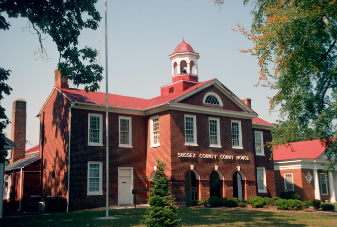
Sussex County is Delaware’s southernmost county, with an area of approximately 3,097 square kilometres and a population of 237,378. Established in 1683, it is the largest of Delaware’s three counties by area and includes Georgetown, the county seat, as well as coastal communities such as Lewes, Rehoboth Beach, and Bethany Beach. The county reaches from the inland Delmarva plain to Delaware Bay and the Atlantic Ocean, with Cape Henlopen forming a prominent coastal landmark near the mouth of Delaware Bay. Inland waterways include the Nanticoke River and Broad Creek, while Cape Henlopen State Park preserves dunes, beaches, and historic military structures.
To the mapData sources: OpenStreetMap (ODbL), Wikidata (CC0) · Image: Wikimedia Commons
| Named after | Delaware Bay |
|---|---|
| Year built | 1787 |
| Area | 6452 km² |
| Elevation | 18 m |
| Located in | United States |
| Country | United States |
| Body of water | Atlantic Ocean, Delaware Bay, Delaware River |
| Population | 989948 |
| Website | https://delaware.gov |
| Nickname | The First State |
| Native name | Delaware |
| Official name | State of Delaware |

 Public transit map Delaware Legend
 | Railway | |
| Bus | |
| Tram |
 Bicycle map Delaware Legend
 | Bike path | |
| Bike lane on roadway | |
| Cycling allowed on bus lane | |
| Bicycle street | |
| Open to cyclists | |
| Open to cyclists, good path | |
| Cycling prohibited | |
| Cobblestone |
| Long-distance bike route | (depending on scale) | |
| Long-distance bike route |
 Pedestrian map Delaware Legend
 | Path |
| Long-distance hiking trail | (depending on scale) | |
| Long-distance hiking trail | ||
| Pedestrians prohibited |