
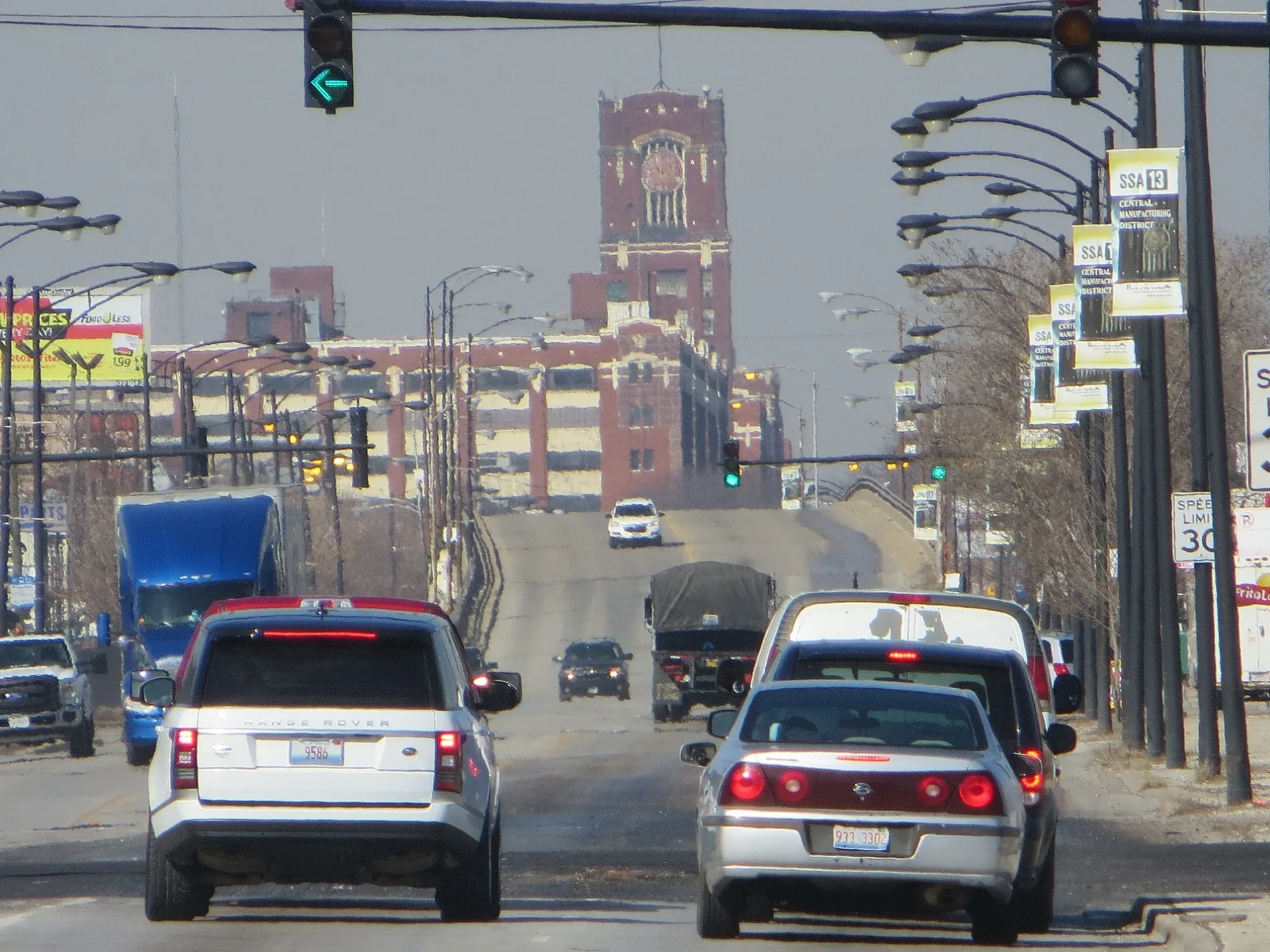
West Pershing Road in Bridgeport, Chicago, Illinois
West Pershing Road in Bridgeport in Chicago is a secondary road and it crosses a bridge. It runs in an east-west direction and crosses South Western Boulevard, South Oakley Avenue, South Bell Avenue, South Irving Avenue, South Leavitt Street, South Hoyne Avenue, South Damen Avenue, South Winchester Avenue, South Wolcott Avenue, South Honore Street, South Wood Street and South Hermitage Avenue. It connects McKinley Park, New City, Armour Square, Brighton Park, Bridgeport and Grand Boulevard. West Pershing Road is also known as 39th Street (Chicago). The nearest stops are Pershing & Halsted, 1111 W Pershing, Pershing & Wallace and Pershing & Canal. The bus line 39 stops here. Ⓦ.
- Road Type
- secondary road
- Route
- east-west
Image
Bus stops
- bus lines 39
Streets nearby
West Pershing RoadPershing & Normal, The BallPark Pub, Pershing & Paulina, Pershing & Morgan, BP Shop, Pershing & Union, 1132 W Pershing
0.1 mi
West 38th StreetShinnick’s Pub
0.2 mi
South Iron StreetMarz Community Brewing
0.2 mi
West 37th StreetThe Stockyard Coffeehouse, U.S. Bank, Halsted St & 37th St
0.2 mi
South Loomis Street0.2 mi
South May Street0.3 mi
South Packers Avenue0.3 mi
West 40th Street0.3 mi
South Wall Street0.3 mi
West 36th Place0.3 mi
West Exchange Avenue0.3 mi
West 42nd Street42nd Street & Halsted
0.4 mi
South Racine AvenueM’Bellish Hair Studio, Racine & Harrison (Blue Line), Racine & 13th Street, Racine & 14th Street, Racine & Roosevelt, CVS Pharmacy, Ventra, Racine Ave & Congress Pkwy, Racine & Lexington, Racine & Cabrini, Racine Ave & 15th St, Racine & Taylor, Racine & 47th Street, Chicago School Of Grappling
0.4 mi
South Loomis Place0.4 mi
South Jasper Place0.4 mi
West 42nd Place0.5 mi
South Laflin Place0.5 mi
West 35th Street35th Street & Aberdeen, 35th Street & Racine, CubeSmart, Heritage Museum of Asian Art, Vjosa Cafe & Events, Chase, Stussy's Diner, 35th Street & Halsted, 35th Street & Union, Bark N' Bites, 35th Street & Wallace, Oscar and Sons Jewlers, Bridgeport Hobby Sports Cards, Prima Lash and Beauty Supply, 35th Street & Normal, Halsted St & 35th St, 35th Street & Lituanica, 35th Street & Morgan, La Mexicana Taqueria, Bridgeport Art Center, Base Community Cafe
0.5 mi
West 38th Place0.5 mi
West 41st Street0.6 mi
West 43rd StreetAdvance Auto Parts, INail, Halsted & 43rd Street, Yao's Cafe Restaurant, Joe's Barbershop
0.6 mi
South Ashland AvenueAshland & 42nd Street, Ashland & 53rd Street, Ashland & Garfield, Ashland & 49th Street, Chase, Ashland & Pershing, Ashland & 52nd Street, ACCESS Ashland Family Health Center, Ashland & 51st Street, Ashland Ave & 50th St, Back of the Yards
0.6 mi
Areas nearby
ComEd Chicago Training Center0.5 mi
Shops nearby
Midwest Carpet & Flooring0.2 mi
Banks nearby
Bank of America0.6 mi
Cafes nearby
Iron Café0.3 mi
Commercial buildings nearby
Chicago Sustainable Manufacturing Center (Bubbly Dynamics)0.3 mi
Tripp Lite0.4 mi
Covered areas nearby
Fleet Management Fuel Station0.2 mi
Fast food restaurants nearby
Vienna Beef Factory Store0.3 mi
Gas stations nearby
BP0.3 mi
Industrial areas nearby
Vulcan Materials Company500 ft
Industrial buildings nearby
National Safety Apparel0.1 mi
Racine Avenue Pumping Station0.2 mi
Vienna Beef0.2 mi
Chicago Deptartment of Streets & Sanitation Garage0.3 mi
Water Management Administration Building0.3 mi
Lakeshore Recycling Systems0.4 mi
Luster Products0.4 mi
Aviation Institute of Maintenance (AIM)0.4 mi
OSI Chicago – Ashland0.5 mi
Mail depots nearby
UPS Morgan Street Center0.2 mi
Railways nearby
CR&I Industrial Track Siding500 ft
CR&I Industrial Track Yard Lead0.5 mi
NS CR&I IT Yard Lead0.5 mi
CR&I Industrial Track0.5 mi
Rivers nearby
South Fork South Branch Chicago River0.2 mi
Self storages nearby
Public Storage0.5 mi
Specialty stores nearby
Columbia Pipe & Supply Co.0.1 mi
Sports centers nearby
Chicago Indoor Sports0.6 mi
| Named after | John J. Pershing |
|---|---|
| Located in | Chicago |
| Country | United States |
Public transit map Bridgeport Legend
| Railway | |
| Bus | |
| Streetcar |
Bicycle map Bridgeport Legend
| Bike path | |
| Bike lane on roadway | |
| Cycling allowed on bus lane | |
| Bicycle street | |
| Open to cyclists | |
| Open to cyclists, good path | |
| Cycling prohibited | |
| Cobblestone |
| Long-distance bike route | (depending on scale) | |
| Long-distance bike route |
Pedestrian map Bridgeport Legend
| Path |
| Long-distance hiking trail | (depending on scale) | |
| Long-distance hiking trail | ||
| Pedestrians prohibited |