
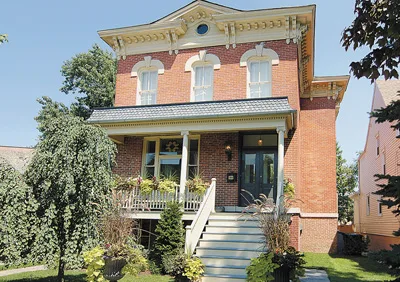
North Kenneth Avenue in Irving Park, Chicago, Illinois
North Kenneth Avenue in Irving Park in Chicago is an asphalted residential street. It runs in a north-south direction starting from West Berteau Avenue and crosses West Irving Park Road and ends at West Byron Street. Nearby there is a bike rental. The nearest bus stop is Milwaukee & Kenton (about 400 m away). North Kenneth Avenue also exists in Forest Glen, Hermosa and Albany Park.
- Road Type
- residential street
- Route
- north-south
Image
Bike rentals
Streets nearby
West Dakin Street400 ft
West Byron StreetThe Friendly Wash
500 ft
North Kilbourn AvenueKilbourn Ave & Irving Park Rd, Grayland, Kilbourn Ave & Roscoe St
0.1 mi
West Larchmont Avenue0.1 mi
North Lowell AvenueMcNamara’s
0.2 mi
North Kostner AvenueKostner Ave & Belmont Ave
0.2 mi
North Kildare AvenueSubway, Kildare Ave & Montrose Ave
0.2 mi
North Kenton Court0.2 mi
North Kenton Avenue0.2 mi
Milwaukee Avenue BikewayMilwaukee & Kilpatrick/Byron, Milwaukee & Irving Park/Cicero, Milwaukee & Kenton, Milwaukee & Kostner, Milwaukee & Kilbourn (Metra), Milwaukee & Waveland, Four Star Auto Mania, Portage Auto Parts, Milwaukee & Kenneth (Metra), Milwaukee & Kilbourn
0.2 mi
West Belle Plaine AvenuePulaski & Belle Plaine, Brickhouse Bar & Grill, The Kedzie Inn
0.3 mi
North Milwaukee Court0.3 mi
North Knox Avenue5th Province
0.3 mi
West Irving Park RoadIrving Park & Tripp, The House of Hansen, Irving Park Blue Line Station, Irving Park & Keystone, Shokran, MoneyTree Genetics, Irving Park & Elston/Monticello, Hearth and Crust, Lucky Charm Cafe, Serbian Village, Irving Park & Kedzie, Kedzie Irving Currency Exchange, Western Union, Irving Park & Kimball, Windy City Playhouse, House of Wah Sun, Fuller's Pub, Tanos Bakery, Irving Park & Spaulding, Rainbow School Daycare, Dunkin', Dharma Garden, Irving Park & Albany, Baskin-Robbins, Lizard’s Liquid Lounge, T-Mobile, Jet's Pizza, Mi Cuidad, Bloodshot Records, Irving Park & Sacramento, Beograd Cafe, Raisu Japanese Fine Dining, LeaderBar Drafthouse & Eatery, Irving Park & Mozart, The Churro Waffle, Irving Park & Francisco, Easy Street Pizza & Patio, Irving Park & Kilbourn, Starbucks, Leona's, Irving Park & Kostner, Irving Park & St. Louis, Irving Park & Hamlin, First Bulgarian Center, Irving Park & Pulaski, Chicago Bibles & Books, Irving Park & Ridgeway, Irving Park & Keeler, The Unforgettable Bar, ERIS Brewery and Cider House, Irving Park & Springfield, Irving Park & Kildare, Berrista Coffee, Chicago Taco Authority, Midtown Funeral Home and Cremation Options, Edible Arrangements, Irving Park, The Pursuit Supply Co., Chicken Works & Salad Company, Irving Park & Central Park, The Music Store, Alex's Hot Dogs, Irving Park & California, 7-Eleven, Subway, Taco Bell, KFC, 2700 W Irving Park, Mr Bubble
0.3 mi
North Tripp Avenue0.3 mi
West Hutchinson Street0.3 mi
North Kilpatrick AvenueMayfair
0.3 mi
Kennedy Express Reversable LaneMontrose, Irving Park Blue Line Station, Irving Park, Addison Blue Line Station, Addison
0.3 mi
West Cuyler AvenueFamous Footwear, DentalWorks, Milwaukee Ave & Cuyler Ave
0.3 mi
West Berteau AvenueT & A Too, Paddy Mac’s
0.3 mi
West Berenice Avenue0.3 mi
North Kolmar Avenue0.3 mi
Kennedy ExpresswayIrving Park & Avondale (Blue Line), Irving Park & Keystone Terminal, Addison, Montrose, Addison Crash Investigation Site, Irving Park Blue Line Station
0.3 mi
Bakeries nearby
Le Parisien0.3 mi
Banks nearby
Bank of America0.3 mi
Bars nearby
The Booze Hound0.3 mi
Car dealerships nearby
Mid City Nissan400 ft
Mid City Subaru0.1 mi
Clinics nearby
Northwestern Medicine Outpatient Center250 ft
Fast food restaurants nearby
Chipotle0.3 mi
Industrial areas nearby
Peoples Gas0.2 mi
Parks nearby
Gertrud Kolmar Park0.3 mi
Pet stores nearby
PetSmart0.3 mi
Places of worship nearby
Irving Park Baptist Church350 ft
Saint John's Episcopal Church0.1 mi
Railways nearby
C&M Subdivision0.3 mi
UP Harvard Subdivision0.3 mi
Cragin Industrial Lead0.4 mi
Residential areas nearby
Old Irving Village0.2 mi
Residential buildings nearby
Kenmill0.3 mi
Restaurants nearby
Chicago's Pizza0.1 mi
Retail areas nearby
Old Irving Park Plaza0.2 mi
Retail buildings nearby
Six Corners Plaza0.4 mi
Social facilities nearby
Lydia Childrens Home0.2 mi
The Clarendale0.3 mi
The Kilpatrick Renaissance0.4 mi
Sports centers nearby
Irving Park YMCA of Metro Chicago0.2 mi
Subway lines nearby
O'Hare Branch0.3 mi
Supermarkets nearby
Jewel-Osco0.3 mi
Public transit map Irving Park Legend
| Railway | |
| Bus | |
| Streetcar |
Bicycle map Irving Park Legend
| Bike path | |
| Bike lane on roadway | |
| Cycling allowed on bus lane | |
| Bicycle street | |
| Open to cyclists | |
| Open to cyclists, good path | |
| Cycling prohibited | |
| Cobblestone |
| Long-distance bike route | (depending on scale) | |
| Long-distance bike route |
Pedestrian map Irving Park Legend
| Path |
| Long-distance hiking trail | (depending on scale) | |
| Long-distance hiking trail | ||
| Pedestrians prohibited |