
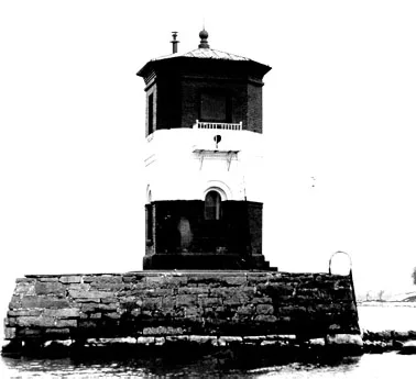
Craighill Channel Upper Range Front Light in Baltimore County, Maryland
Craighill Channel Upper Range Front Light in Baltimore County is a lighthouse. Craighill Channel Upper Range Front Light is located near Gettysburg Avenue. Ⓦ.
- Building Type
- lighthouse
Image
Streets nearby
Gettysburg Avenue0.2 mi
Patapsco Street0.2 mi
Key Street0.2 mi
Fredericksburg Street0.3 mi
San Juan Avenue0.3 mi
McHenry Street0.3 mi
Weldon Street0.4 mi
Antietam Street0.4 mi
Fort Howard Park RoadLighthouse
0.4 mi
Blank Avenue0.5 mi
Fort Avenue0.5 mi
Oak Street0.6 mi
Howard Avenue0.6 mi
Chestnut Avenue0.6 mi
Todd Avenue0.6 mi
North Point RoadThe Landing, Edgemere Fire Department Station 9, Edgemere's Icy Delights, Molly's Coffee & Cafe, Captain Jummy’s Crab House, Lifeway Pharmacy, Cashmart, 1107 North Point Road Northbound, North Point Road & Hackett Avenue Northbound, North Point Road & Willow Road Southbound, North Point Road & Willow Road Northbound, North Point Road & Maple Road Opposite Northbound, Poor Boys Sports, 7-Eleven, Bob’s Auto Service, DJ Liquidators, Warehouse Tile & Carpet, Drug City Pharmacy, Old North Point Road & Kimberly Road Opposite Southbound, North Point Road & Charlesmont Road Southbound, North Point Road & Parkwood Road Southbound, North Point Road & Kimberly Road Far-side Northbound, North Point Road & Norris Lane Northbound, North Point Road & Charlesmont Road Northbound, Battle of North Point, Battle of North Point Memorial Museum, Bay Vanguard Bank, North Point Road & Willow Southbound Far-side
0.6 mi
Bayside AvenueFort Howard
0.7 mi
Shadyside Lane0.8 mi
Old Bay RoadFort Howard Post Office
0.9 mi
Denton Avenue1.0 mi
Old Road Bay Front1.3 mi
Ross Road1.3 mi
Ore Pier Road1.3 mi
Hiker-Biker Trail1.3 mi
Wharf Road1.3 mi
Avenue C1.3 mi
Avenue A1.3 mi
Attractions nearby
Todd Farmhouse1.3 mi
Buildings nearby
Mine Storage Building0.2 mi
Quarters Building0.4 mi
Bunkers nearby
Battery Nicholson0.2 mi
Battery Stricker0.3 mi
Battery Harris0.3 mi
Battery Key0.4 mi
Battery Clagett0.4 mi
Houses nearby
Marc & Jean Skogland0.9 mi
Industrial buildings nearby
Lehigh Cement1.2 mi
Parks nearby
Fort Howard Veterans Park1.0 mi
Places of worship nearby
Fort Howard Community Church0.9 mi
Playgrounds nearby
Fort Howard Park Playground #10.3 mi
Fort Howard Park Playground #20.4 mi
Residential buildings nearby
Building 80.2 mi
Building 90.2 mi
Building 100.2 mi
Building 110.2 mi
Building 120.3 mi
Building 130.3 mi
Building 140.3 mi
Tourist information centers nearby
Takos Visitor Center1.3 mi
| Height | 5.5 m |
|---|---|
| Heritage designation | National Register of Historic Places listed place |
| Located in | Baltimore County |
| Country | United States |
| Part of | Craighill Channel range lights |
 Public transit map Baltimore County Legend
| Railway | |
| Bus | |
| Streetcar |
 Bicycle map Baltimore County Legend
| Bike path | |
| Bike lane on roadway | |
| Cycling allowed on bus lane | |
| Bicycle street | |
| Open to cyclists | |
| Open to cyclists, good path | |
| Cycling prohibited | |
| Cobblestone |
| Long-distance bike route | (depending on scale) | |
| Long-distance bike route |
 Pedestrian map Baltimore County Legend
| Path |
| Long-distance hiking trail | (depending on scale) | |
| Long-distance hiking trail | ||
| Pedestrians prohibited |