
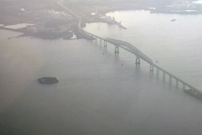
Fort Carroll in Baltimore County, Maryland
Fort Carroll in Baltimore County is a fort. Fort Carroll is also known as llmarti. Fort Carroll is located near Authority Drive. Ⓦ.
- Nature
- coastline
Image
Streets nearby
Fort Armistead Road1.1 mi
Authority Drive1.1 mi
Inspection Station1.1 mi
Baltimore Beltway1.3 mi
Breckenbridge DriveSollers Point
1.4 mi
Coal Plant Road1.5 mi
Shipyard RoadGate D, Tradepoint Atlantic - Pasha Automotive
1.5 mi
Broening HighwaySollers
1.5 mi
South LaneCCBC Essex Loop
1.5 mi
Mount Olive RoadTurners Station Branch Baltimore County Public Library
1.5 mi
Fleming DriveFleming Drive & Main Street Eastbound, Fleming Drive & New Pittsburg Avenue Southbound
1.7 mi
New Pittsburg Avenue1.7 mi
Main StreetReisterstown, Hanover Pike & Westminster Pike Northbound, Main Street & Village Center Road Southbound, China Jade, Hunt Valley, The Mint Leaf, Dave's Hot Chicken, White House Black Market, Chico's, Panera Bread, Chipotle, Tous les Jours, The Good Feet Store, Sleep Number, Loft, Coal Fire, Tropical Smoothie Cafe, Quickway Japanese Hibachi, Mattress Warehouse, Hunt Valley Wine, Liquor & Beer, Eileen Fisher, Main Street & Avon Beach Road Southbound, Main Street & Chestnut Street Southbound, Main Street & Sollers Point Road Southbound, Main Street & Avon Beach Road Northbound, Main Street & Sollers Point Road Northbound, Main Street & Bond Avenue Northbound, Main Street & Glyndon Trace Drive Opposite Southbound, Main Street & Glyndon Drive Far-side Northbound, Belinda’s Salon on Main, The Cow, Main Street & Bond Avenue Opposite Southbound, Main Street & Chartley Drive Northbound, Main Street & Chartley Drive Southbound, Main Street & Cockeys Mill Road Southbound, Main Street & Cockeys Mill Road Opposite Northbound
1.7 mi
Lee Lawrence Court1.7 mi
Calvin Hill Court1.7 mi
Kweisi Mfume Court1.7 mi
Glenard Middleton CourtSouth Avondale Road & Glenard Middleton Court Eastbound
1.7 mi
Carver Road1.7 mi
William Wade AvenueWilliam Wade Avenue & Avondale Road Northbound
1.8 mi
Maple Lane1.8 mi
Anjeu Reuss Court1.8 mi
South Avondale RoadAvondale Road & Flora Drive Near-side Northbound
1.8 mi
Centre AvenueHillendale Press, Inc
1.8 mi
Woodland Avenue1.8 mi
H Street1.8 mi
Balnew Avenue1.8 mi
Cottage Avenue1.8 mi
Patapsco Avenue1.8 mi
Avon Avenue1.8 mi
Cedar AvenueRelay
1.8 mi
Ash Avenue1.8 mi
Buildings nearby
Fort Carroll Lighthouse400 ft
Fort Armistead0.9 mi
Community centers nearby
Fleming Community Center1.7 mi
Construction sites nearby
Tradepoint Atlantic Shipyard1.2 mi
Industrial areas nearby
Hawkins Point Marine Terminal1.2 mi
Dundalk Marine Terminal1.8 mi
Landfills nearby
Cox Creek Dredged Material Containment Facility1.1 mi
Office buildings nearby
Walter E. Woodford, Jr. Building1.1 mi
Parks nearby
Fort Armistead Park0.8 mi
Lyons Homes Park1.6 mi
Fleming Park1.7 mi
Places of worship nearby
Mount Olive Baptist Church1.5 mi
Gospel Tabernacle Church1.8 mi
Friends Baptist Church1.8 mi
Police stations nearby
Maryland Transportation Authority1.4 mi
Rivers nearby
Bear Creek0.4 mi
Sports fields nearby
Turner's Rec Soccer/Football FIeld1.7 mi
Wetlands nearby
Cox Creek/Swan Creek Wetland1.4 mi
| Heritage designation | National Register of Historic Places listed place |
|---|---|
| Located in | Baltimore County |
| Country | United States |
| Described by | FortWiki, Starforts, Military Reservation at Fort Carroll (NAID 77452237), Plan of Fort Carrol, Maryland (NAID 137929243) |
 Public transit map Baltimore County Legend
 | Railway | |
| Bus | |
| Streetcar |
 Bicycle map Baltimore County Legend
 | Bike path | |
| Bike lane on roadway | |
| Cycling allowed on bus lane | |
| Bicycle street | |
| Open to cyclists | |
| Open to cyclists, good path | |
| Cycling prohibited | |
| Cobblestone |
| Long-distance bike route | (depending on scale) | |
| Long-distance bike route |
 Pedestrian map Baltimore County Legend
 | Path |
| Long-distance hiking trail | (depending on scale) | |
| Long-distance hiking trail | ||
| Pedestrians prohibited |