
Bay Bridge in Stevensville, MD 21666
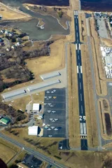
Bay Bridge in Stevensville, MD 21666 (Queen Anne's County) is an airfield. Bay Bridge is also known as W29. Ⓦ.
Image
Streets nearby
Romancoke RoadWiggins Corner, Kent Island Estates, Mattapex, Sweet Stuff Cafe
400 ft
Thompson Creek RoadKent Island Park & Ride
0.2 mi
Airport Road0.2 mi
Mikes Way0.2 mi
Liam Thomas Lane0.2 mi
Kent Manor DriveKent Manor Inn
0.2 mi
Blue Star Memorial HighwaySherwin-Williams, Verizon, Kent Island Dentistry, Welcome To Queen Anne County, Tesla Supercharger
0.3 mi
Business Parkway0.3 mi
Ellendale Boulevard0.3 mi
Ellendale Farm Lane0.3 mi
Jessica Lyn Avenue0.3 mi
Kennan Way0.3 mi
Cable House Road0.3 mi
Pier One Roadthe Market
0.3 mi
Thompson Creek Service RoadStevensville Post Office
0.3 mi
Parker Drive0.4 mi
Bridge Court0.4 mi
Breeding Boulevard0.4 mi
Alexis Avenue0.4 mi
Marina Club Road0.4 mi
Allison Jane Drive0.4 mi
Love Point RoadLove Point
0.4 mi
Anna Carol Drive0.4 mi
Wallman Way0.4 mi
Calvert Road0.4 mi
Moorings Circle0.5 mi
John Patrick Drive0.5 mi
Conner Drive0.5 mi
Creekside Commons CourtKent Cove
0.5 mi
Saint Claire Place0.5 mi
Main StreetGrasonville Post Office, Jinx's Liquors, Dollar General, El Jefe Mexican Kitchen & Tequila Bar, Toyko Bay, Island Tackle Outfitters, Walgreens, Coastal Run, Sharktown, Kent Narrows, Grasonville Senior Center, Graysonville Senior Center, Paws N Claws Pet Spa, Water Wizard, Inc.
0.5 mi
Topside Drive0.6 mi
Victoria Way0.6 mi
Irene Way0.6 mi
Victoria Drive0.6 mi
Swan Road0.6 mi
Antique stores nearby
DejaBlu Vintage0.5 mi
Stevensville Antiques0.5 mi
Buildings nearby
Chesapeake Bay Beach Club0.5 mi
Cafes nearby
Big Bats Cafe0.4 mi
Carpet stores nearby
Kent Island Floor Coverings0.5 mi
Cemeteries nearby
Broad Creek Cemetery0.3 mi
Gardens nearby
Garden of Queen Anne0.3 mi
Gas stations nearby
BP0.2 mi
Valero0.5 mi
Marinas nearby
Bay Bridge Marina0.6 mi
Restaurants nearby
Knoxie's Table0.3 mi
Retail areas nearby
Kent Landing0.3 mi
Other nearby
Stevensville Substation0.1 mi
| Named after | Chesapeake Bay Bridge |
|---|---|
| Elevation | 14 |
| Located in | Queen Anne's County |
| Country | United States |
| Website | http://www.baybridgeairport.net/ |
| Location | Stevensville |
 Public transit map Queen Anne's County Legend
| Railway | |
| Bus | |
| Streetcar |
 Bicycle map Queen Anne's County Legend
| Bike path | |
| Bike lane on roadway | |
| Cycling allowed on bus lane | |
| Bicycle street | |
| Open to cyclists | |
| Open to cyclists, good path | |
| Cycling prohibited | |
| Cobblestone |
| Long-distance bike route | (depending on scale) | |
| Long-distance bike route |
 Pedestrian map Queen Anne's County Legend
| Path |
| Long-distance hiking trail | (depending on scale) | |
| Long-distance hiking trail | ||
| Pedestrians prohibited |