
The Newbern in Kansas City, Missouri
The Newbern in Kansas City is a building, East Armour Boulevard 525 (64109). Ⓦ.
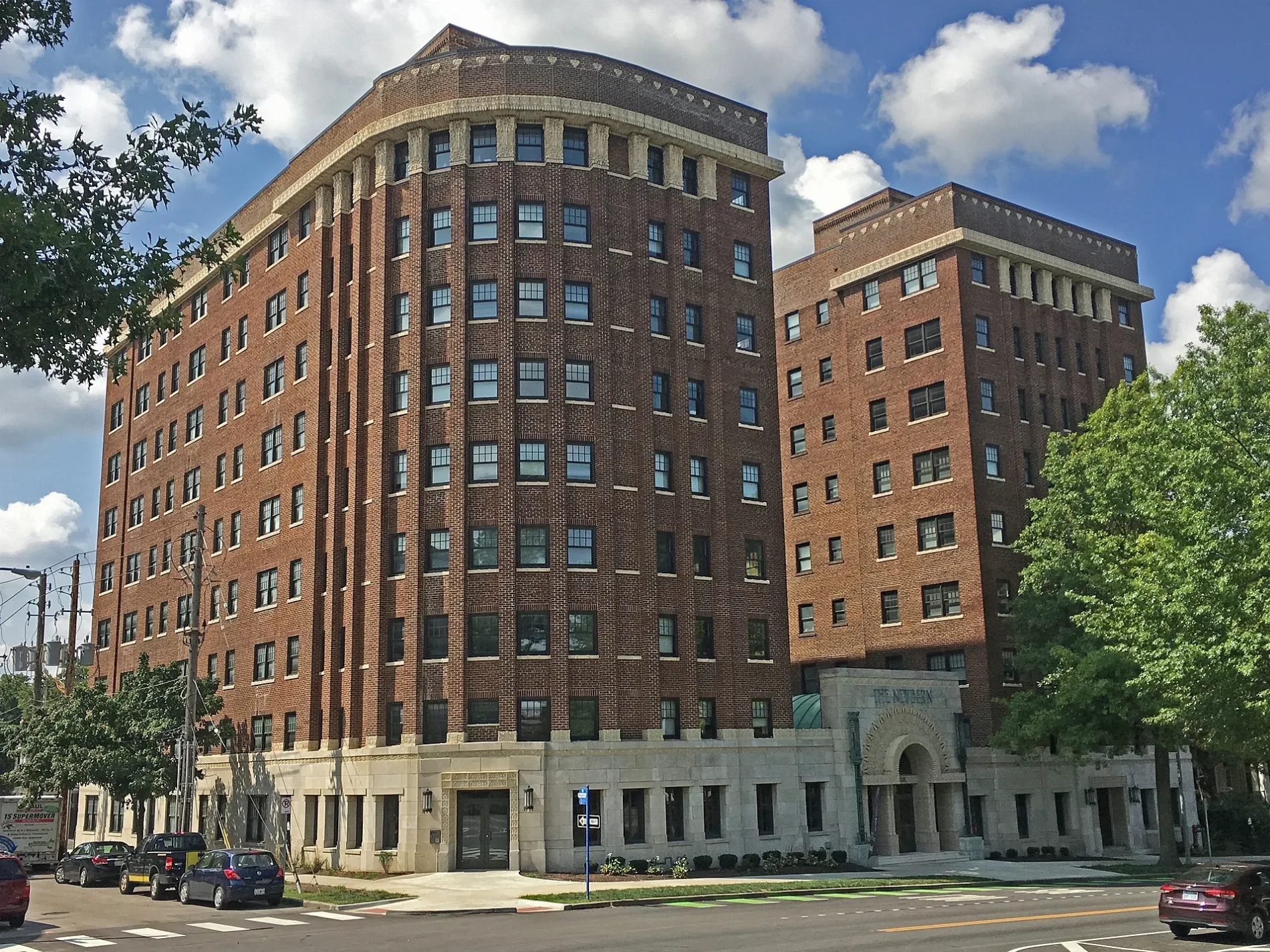
- House Number
- 525
- Street
- East Armour Boulevard
- Postal Code
- 64109
- Building Type
- building
Bus stops
Cafes
Gas stations
Self storages
Tire dealers
Hair salons
Bars
Event venues
Pharmacies
Auto parts stores
Streetcar stops
Streets nearby
Cherry StreetRatcliff Gutter Supply Company, Kansas City Rescue Mission, Oak Meyer Gardens, Disco Burger, The Abbott
300 ft
Locust StreetThe Pulse Performing Arts Center, Christian Science, Red Bridge Congregation of Jehovahs Witnesses, KC Conjure & Botanica, Arrow Dart & Sports Club, Cosmo Burger, The Limit Pub & Grub, Made in KC Neighborhood Shop, American Coin, Berries + Honey Charcuterie, Caleb's Breakfast & Lunch, Euston Hardware, Mid-Continent Public Library - Red Bridge Branch
350 ft
Gillham RoadOur Lady of Sorrows School, Gillham at Armour, O'Reilly Auto Parts, ABC, Brewer's Kitchen, Good Karma, Union on the Hill, Gillham at 31st, 1888 Coffee House, Value Auto Clinic, Bringing the Pieces Together
0.1 mi
Kenwood AvenueCountryside Animal Clinic
0.1 mi
East 34th TerraceMain Smoke & Gift Shop, Crisp Cuts & Styles
0.2 mi
East Armour BoulevardArmour at Warwick, Armour at Troost, Armour at Tracy, Armour at Cherry, Armour at Gillham, Armour at Holmes, Armour at Campbell, Armour at Main, Loose Mansion, Armour at The Paseo
0.2 mi
McGee StreetSouthmoreland, Prohibition Hall, Zoo Bar, From the Earth Dispensary, The UPS Store, Imagine That Kansas City, Union Hill, McGee at Pershing, McGee at 22nd, The Brick, Papa John's, Ted's Taproom, Josey Records, Mod Art Gallery, KC Brake and Auto Repair, Christopher Elbow Chocolates, Peace Church UCC, Ricochet, Taylor Elizabeth Cakes
0.2 mi
Oak StreetTower Tavern, Prefix Coffee, Anjin, Lilico's Taverna, The Sound Environment, Arizona Trading Company, Federal Courthouse, Shuttlecocks, City Hall, Break Time, Oak at 11th, Tower Homes, Shopgirls, Brookside Guitars, Vita's Place, Savvy Bridal, Oak at 13th
0.2 mi
Charlotte StreetWord of Faith Christian Center, South Hyde Park, Penn Valley Monthly Meeting, Charlotte at 25th, Subway, Charlotte at 10th, Hospital Hill, Bay L, 12th and Charlotte Transit Hub, North Hyde Park, Charlotte at 22nd, Crossroads East, Charlotte at 6th, Charlotte at Admiral, Hope Faith Ministries
0.2 mi
Holmes StreetHolmes at 13th, Central Hyde Park, Rockhill, Holmes at 25th, Hospital Hill, Western 49/63
0.2 mi
East 33rd StreetSidestreet Bar, Jackson at 33rd
0.2 mi
Janssen Place Crossing0.2 mi
East 34th StreetLamar's Donuts, Great Clips, Verizon, Prospect at 34th, Bloodline Studios, Teeshia's Taste Cafe, One Stop Party Shop
0.2 mi
Warwick Boulevard0.2 mi
Campbell StreetCampbell at 21st, Studios Inc., Thanh Tung Video Gifts
0.3 mi
East 37th StreetJackson at 37th, Main at 37th, Midtown Tattoo, Ivanhoe Northeast, The Paseo at 37th
0.3 mi
Harrison Boulevard0.3 mi
East 36th StreetProspect at 36th
0.3 mi
Gleed Terrace0.3 mi
Janssen Place0.4 mi
Harrison Parkway0.4 mi
Susan Robards Way0.4 mi
Manheim Road0.4 mi
Apartment buildings nearby
520 East350 ft
Clyde Manor0.1 mi
The Hamilton0.1 mi
The International0.2 mi
Park Central0.2 mi
Bellerive0.2 mi
Notre Dame Apartments0.3 mi
Buildings nearby
The Windemere100 ft
The Windsor Manor400 ft
The Sombart450 ft
The Richelieu450 ft
Georgian Court Apartments0.1 mi
LimoTrac0.2 mi
Brownhardt Apartments0.2 mi
Hyde Park Place Apartments0.2 mi
Park Regency Condominiums0.2 mi
The Ricardo0.2 mi
The Bainbridge0.3 mi
Car dealerships nearby
T & Z Motors0.2 mi
Parks nearby
Commonwealth Green0.1 mi
Places of worship nearby
Trinity United Methodist Church300 ft
Central Presbyterian Church0.3 mi
School buildings nearby
Académie Lafayette Elementary School0.1 mi
Notre Dame de Sion School0.4 mi
Social facilities nearby
Clara Manor Nursing Home0.3 mi
Stadiums nearby
Derek Thomas Memorial Field0.3 mi
| Year built | 1921 |
|---|---|
| Heritage designation | National Register of Historic Places listed place |
| Located in | Kansas City |
| Country | United States |
Public transit map Kansas City Legend
| Railway | |
| Bus | |
| Streetcar |
Bicycle map Kansas City Legend
| Bike path | |
| Bike lane on roadway | |
| Cycling allowed on bus lane | |
| Bicycle street | |
| Open to cyclists | |
| Open to cyclists, good path | |
| Cycling prohibited | |
| Cobblestone |
| Long-distance bike route | (depending on scale) | |
| Long-distance bike route |
Pedestrian map Kansas City Legend
| Path |
| Long-distance hiking trail | (depending on scale) | |
| Long-distance hiking trail | ||
| Pedestrians prohibited |