
The Strat in Las Vegas
The Strat in Las Vegas is a hotel (wheelchair accessible), South Las Vegas Boulevard 2000 (89104). The Strat is also known as Stratosphere Hotel & Casino. Ⓦ.
- House Number
- 2000
- Postal Code
- 89104
- Street
- South Las Vegas Boulevard
- Amenity
- casino
- Building Type
- hotel
- Tourism
- hotel
- Website
- https://stratospherehotel.com/
- Wheelchair Access
- yes
Image
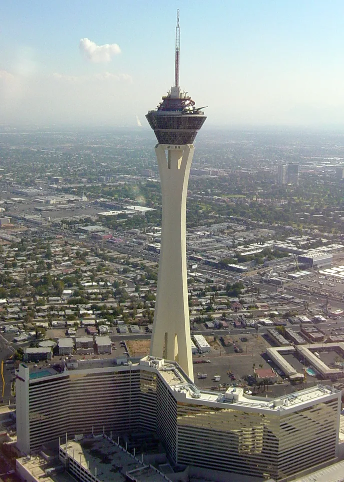
Streets nearby
Bob Stupak AvenueAztec Inn Casino, PT’s pub, $5 Cafe
150 ft
West Cleveland Avenue450 ft
West Baltimore Avenue0.1 mi
West Philadelphia Avenue0.2 mi
South Las Vegas BoulevardNorthbound Las Vegas after Saint Louis, Northbound Las Vegas before Oakey, Golden West Motel, Las Vegas Blvd @ 4th St., Southbound Las Vegas after Oakey, Charleston, Broken Yolk Cafe, Chapel of the Bells, Essence cannabis dispensary, Southbound Las Vegas at the Strat, Fellini’s Ristorante Italiano, CBar, X-Scream, Alarmco Locksmiths, Southbound Las Vegas before Clark, Southbound Las Vegas before Carson, Las Vegas Blvd @ Hoover, Pawn Plaza, Sahara, Northbound Las Vegas at the Sahara, Top of The World, Big Shot, The Strat, Northbound Las Vegas at the STRAT, Elvis Bridal & Tux, Little Vegas Chapel
0.2 mi
West Cincinnati Avenue0.2 mi
West Saint Louis AvenueEl Nopal Mexican Grill, The Strat
0.2 mi
Paradise RoadBourbon Street Bar and Grill, Northbound Paradise before Saint Louis, Thai Pepper, Southbound Paradise before Sahara
0.2 mi
West Boston AvenueMeadows Village Library, Stupak Community Center, 7-Eleven
0.2 mi
East Saint Louis AvenueAdult Education Programs School, Eastbound Saint Louis after Las Vegas, El Camino a Cristo Lutheran Church, Chinese Baptist Church, First Southern Baptist Church, Trinity Life Center Assembly of God Church, Trinity Christian Schools
0.2 mi
West Chicago Avenue0.2 mi
El Centro Place0.3 mi
West New York Avenue0.3 mi
Santa Paula Drive0.3 mi
South Main StreetLas Vegas, Northbound Main after Las Vegas, Babystacks, Arts District South, Tiendo El Salvador, Vintage Vegas, reBar, Davy's, Koolsville Tattoo, Main Street Mercantile, Greyhound, Southbound Main after Bridger, Northbound Main after Bridger, Northbound Main before Hoover, Northbound Main after Charleston, Salon De Belleza, Su Salud, FANTASTIC DISCOUNT, Main & Utah, Northbound Main before Utah, Northbound Main before Colorado, SALS FURNITURE, Fremont Street Experience, Las Vegas Showgirl Sign
0.3 mi
West Oakey BoulevardBuffalo
0.3 mi
East Oakey Boulevard0.3 mi
Industrial RoadCobalt Truck Equipment
0.4 mi
Weldon Place0.4 mi
Fairfield AvenueAmazon Locker
0.4 mi
West Wyoming AvenueWyoming Avenue, Meadows Village, 76, Amancer, El y Ella Beauty Salon
0.4 mi
South Commerce StreetSouthbound Commerce before Wyoming, Southbound Commerce before California, Southbound Commerce before Imperial, Stray Pirate, Southbound Commerce before Charleston
0.4 mi
East Wyoming Avenue0.4 mi
Amusement parks nearby
The Strat Thrill Rides500 ft
Attractions nearby
Las Vegas Boulevard Gateway Arches450 ft
Stratosphere Tower500 ft
Commercial areas nearby
Top Of The World Las Vegas400 ft
Commercial buildings nearby
Atomic Golf0.2 mi
Convenience stores nearby
7-Eleven0.4 mi
Event venues nearby
Chapel of the Flowers0.4 mi
Fast food restaurants nearby
Subway0.1 mi
Carl's Jr.0.2 mi
McDonald's0.2 mi
Gas stations nearby
Circle K550 ft
Gift shops nearby
Bonanza Gift Shop0.2 mi
Jewelry stores nearby
Native American Jewelry0.4 mi
Motels nearby
Holiday Motel450 ft
El Mirador Motel Las Vegas0.1 mi
St. Louis Manor0.2 mi
Rummel Motel0.3 mi
Oasis Motel;Sweethearts Wedding Chapel & Bridal Boutique0.3 mi
Parks nearby
Chester Stupak Park0.2 mi
Pawn shops nearby
Cash America Pawn0.3 mi
Residential areas nearby
Allure Las Vegas0.2 mi
Restaurants nearby
Denny's0.3 mi
IHOP0.3 mi
Tacos Mexico0.3 mi
Retail areas nearby
Saint Louis Square0.2 mi
Swimming pools nearby
Elation Pool200 ft
| Year built | 1996 |
|---|---|
| Official opening | 1996 |
| Located in | Las Vegas |
| Country | United States |
 Public transit map Las Vegas Legend
| Railway | |
| Bus | |
| Streetcar |
 Bicycle map Las Vegas Legend
| Bike path | |
| Bike lane on roadway | |
| Cycling allowed on bus lane | |
| Bicycle street | |
| Open to cyclists | |
| Open to cyclists, good path | |
| Cycling prohibited | |
| Cobblestone |
| Long-distance bike route | (depending on scale) | |
| Long-distance bike route |
 Pedestrian map Las Vegas Legend
| Path |
| Long-distance hiking trail | (depending on scale) | |
| Long-distance hiking trail | ||
| Pedestrians prohibited |