
Wyoming

Wyoming
This page is the City map of Wyoming, a state of the United States with streets, paths and places shown across its regional territory. Wyoming covers approximately 253,348 square kilometres and lies at an elevation of about 2,040 metres. The state had 576,851 residents in 2020, compared with 563,626 in 2010. Founded in 1890, Wyoming is known for landscapes including the Rocky Mountains, the Great Plains and Yellowstone National Park. A long-distance cycling route, the Great Divide Mountain Bike Route, crosses Wyoming.
Frannie

Frannie is a town in Wyoming and is classified as an administrative level 8 place. It lies in the northern part of the state near the Montana border and is associated with Big Horn County.
The town is located near the Clarks Fork of the Yellowstone River and northeast of the Bighorn Mountains. Roads around Frannie connect the settlement with nearby communities such as Powell and Lovell.
To the mapFremont County

Fremont County lies in western Wyoming and was established in 1884. It covers approximately 23,998 square kilometres and had 39,234 residents in the cited population data.
The county includes Riverton, Lander and Dubois, while the Wind River and the Wind River Range define major parts of its geography. The eastern area contains the Wind River Indian Reservation, and the county reaches toward the Continental Divide.
To the mapNatrona County

Natrona County was established in 1888 and covers about 13,923 square kilometres. Its cited population is 79,955, making it one of Wyoming’s more populous counties.
Casper is the county seat and stands on the North Platte River near Casper Mountain. The county includes portions of the central Wyoming basins and lies close to the Oregon, California, Mormon Pioneer and Pony Express historic trails.
To the mapWashakie County

Washakie County was established in 1913 and covers approximately 5,809 square kilometres. The county has a cited population of 7,685 and is located in north-central Wyoming.
Worland is the county seat and lies in the Bighorn Basin along the Big Horn River. Thermopolis and the adjacent Hot Springs State Park are located to the south in Hot Springs County, while the eastern horizon is formed by the Bighorn Mountains.
To the mapHot Springs County

Hot Springs County is an administrative level 6 county in central Wyoming. Its county seat, Thermopolis, is located in the Bighorn Basin along the Big Horn River.
Thermopolis contains Hot Springs State Park, where mineral springs discharge near the river. The county also includes access to the Wind River Canyon, a deep gorge connecting the Bighorn Basin with the Wind River region.
To the mapPark County

Park County occupies the northwestern corner of Wyoming and was established in 1911. It covers about 18,044 square kilometres and has a cited population of 29,624.
Cody is the county seat, while the western part includes Yellowstone National Park and the Absaroka Range. The Yellowstone, Shoshone and Clark’s Fork rivers are among the major waterways associated with the county.
To the mapCarbon County

Carbon County is located in southern Wyoming and has a cited population of 15,559. Rawlins is the county seat and an important settlement on the Union Pacific rail corridor.
The county extends across the Medicine Bow Mountains and the high plains around the North Platte River. Interstate 80 crosses Carbon County from east to west, linking Rawlins with Laramie and Rock Springs.
To the mapJohnson County

Johnson County was established in 1881 and covers approximately 10,812 square kilometres. Its cited population is 8,447, and Buffalo is the county seat.
The county lies between the Bighorn Mountains and the Powder River Basin. The town of Kaycee and the nearby Hole-in-the-Wall area are associated with the history of cattle ranching and outlaws in northern Wyoming.
To the mapConverse County

Converse County was established in 1888 and covers about 11,047 square kilometres. It has a cited population of 13,751 and is situated in east-central Wyoming.
Douglas is the county seat and stands along the North Platte River. The county contains parts of the Laramie Mountains and the Powder River Basin, while Interstate 25 connects Douglas with Casper and Cheyenne.
To the mapCampbell County

Campbell County lies in northeastern Wyoming and was established in 1911. It covers approximately 12,436 square kilometres and has a cited population of 47,026.
Gillette is the county seat and the largest community in the county. Campbell County forms part of the Powder River Basin, one of the major coal-producing regions of the United States, and the Belle Fourche River runs through the area.
To the mapSheridan County
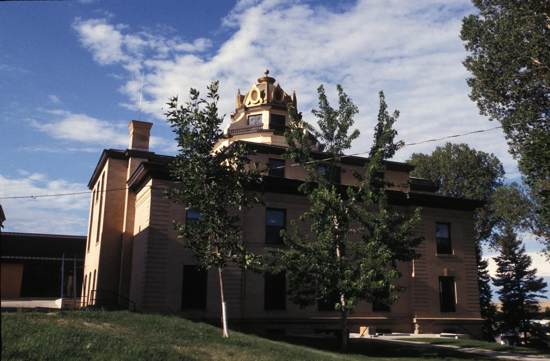
Sheridan County was established in 1888 and covers about 6,545 square kilometres. Its cited population is 30,921, and Sheridan is the county seat.
The county lies at the foot of the Bighorn Mountains near the Montana border. The Bighorn National Forest occupies large mountain areas west of Sheridan, while Interstate 90 crosses the county from east to west.
To the mapTeton County
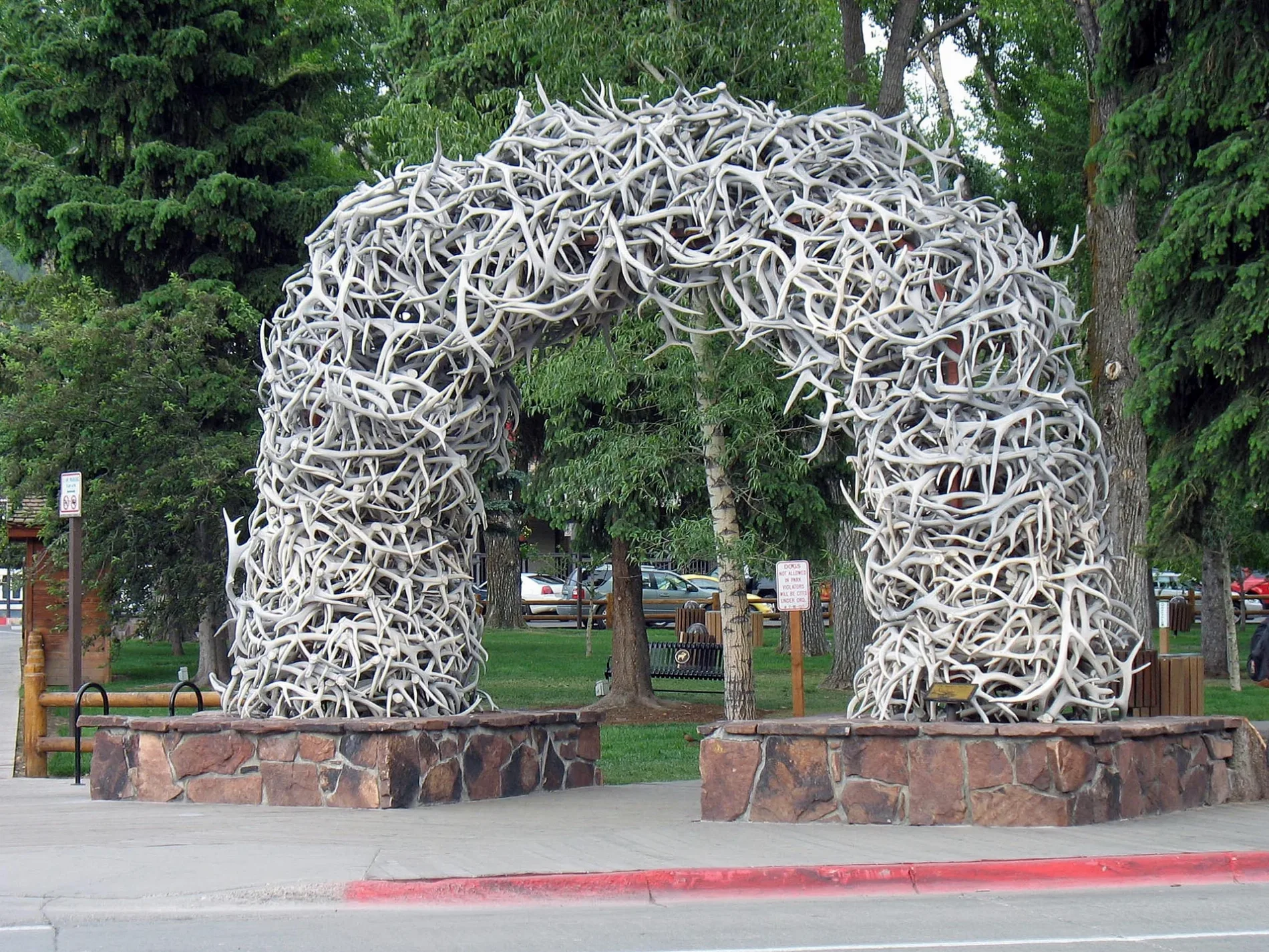
Teton County was established in 1922 and covers approximately 10,934 square kilometres. It has a cited population of 23,331 and is located in northwestern Wyoming.
Jackson is the county seat and the principal community of Jackson Hole. Grand Teton National Park contains the Teton Range and Jackson Lake, while the northern part of the county adjoins Yellowstone National Park.
To the mapSublette County

Sublette County lies in western Wyoming and was established in 1923. It covers about 12,783 square kilometres and has a cited population of 8,728.
Pinedale is the county seat and lies west of the Wind River Range. The Green River rises in the Wind River Mountains and flows south through the county toward the Colorado River system.
To the mapLincoln County

Lincoln County was established in 1913 and covers approximately 10,590 square kilometres. Its cited population is 19,581, and Kemmerer is the county seat.
The county extends along the western border of Wyoming near Idaho and Utah. The Green River, Bear River and Wyoming Range are prominent geographic features, while Fossil Butte National Monument preserves fossils from the Eocene Green River Formation.
To the mapPlatte County
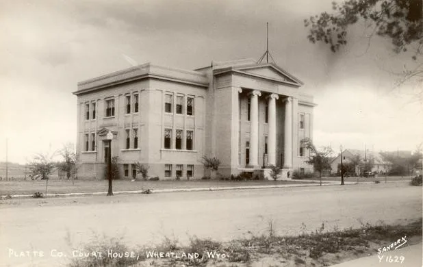
Platte County was established in 1913 and covers about 5,467 square kilometres. It has a cited population of 8,605 and is located in southeastern Wyoming.
Wheatland is the county seat, and the North Platte River crosses the county. The Laramie Mountains rise west of the river, while Interstate 25 connects Platte County with Cheyenne and Casper.
To the mapGoshen County

Goshen County was established in 1911 and covers approximately 5,781 square kilometres. Its cited population is 12,498, and Torrington is the county seat.
The county lies along the North Platte River in southeastern Wyoming near the Nebraska border. Fort Laramie National Historic Site preserves buildings and archaeological remains from the former nineteenth-century military post near the river.
To the mapNiobrara County

Niobrara County is an administrative level 6 county in eastern Wyoming. Lusk is the county seat and lies near the Niobrara River in the eastern part of the state.
The county is located between the Pine Ridge region and the Laramie Mountains. U.S. Highway 18 and U.S. Highway 20 cross Niobrara County, connecting Lusk with communities in Wyoming, Nebraska and South Dakota.
To the mapWeston County

Weston County was established in 1890 and covers approximately 6,216 square kilometres. It has a cited population of 6,838, and Newcastle is the county seat.
The county lies in northeastern Wyoming near the Black Hills and the South Dakota border. Newcastle developed as a historic coal and railroad town, while U.S. Highway 85 crosses the county from north to south.
To the mapCrook County
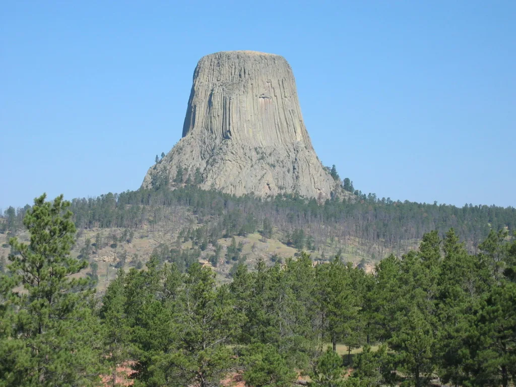
Crook County occupies the northeastern corner of Wyoming and was established in 1875. It covers about 7,435 square kilometres and has a cited population of 7,181.
Sundance is the county seat, and the county borders South Dakota and Montana. Devils Tower National Monument, the first United States national monument designated in 1906, stands in the southwestern part of Crook County.
To the mapBig Horn County

Big Horn County lies in northern Wyoming and was established in 1897. It covers approximately 8,162 square kilometres and has a cited population of 11,521.
Basin is the county seat, while communities such as Lovell and Greybull lie in the Bighorn Basin. The Bighorn River flows through the county, and the Bighorn Canyon region extends along the northern part of the river system.
To the mapUinta County

Uinta County was established in 1869 and covers about 5,407 square kilometres. Its cited population is 20,450, and Evanston is the county seat.
The county lies in southwestern Wyoming near the Utah border and includes the Bear River valley. Interstate 80 crosses Evanston and connects the county with Salt Lake City to the west and southern Wyoming to the east.
To the mapAlbany County

Albany County was established in 1868 and covers approximately 11,160 square kilometres. It has a cited population of 37,066, and Laramie is the county seat.
The county contains the southeastern portion of the Medicine Bow Mountains and the high plains around the Laramie River. The University of Wyoming is located in Laramie, and Interstate 80 crosses the county near the city.
To the mapLaramie County

Laramie County occupies the southeastern corner of Wyoming and was established in 1867. It covers about 6,961 square kilometres and has a cited population of 100,512.
Cheyenne is the county seat and the capital of Wyoming. The city lies near the Colorado border, and Interstate 25, Interstate 80 and the Union Pacific railroad meet in the county.
To the mapSweetwater County

Sweetwater County is located in southwestern Wyoming and has a cited population of 44,626. Green River is the county seat, while Rock Springs is the largest urban centre in the county.
The county includes broad portions of the Great Divide Basin and the Green River valley. Interstate 80 crosses Sweetwater County, and the Continental Divide runs through the region east of Rock Springs.
To the mapData sources: OpenStreetMap (ODbL), Wikidata (CC0) · Image: Wikimedia Commons
| Named after | Wyoming Valley |
|---|---|
| Year built | 1890 |
| Area | 253348 km² |
| Elevation | 2040 m |
| Located in | United States |
| Country | United States |
| Population | 576851 |
| Website | http://wyoming.gov |
| Nickname | Equality State |
| Native name | Wyoming |
| Official name | State of Wyoming |
| Described by | Encyclopædia Britannica Ninth Edition, Encyclopædia Britannica 11th edition, The American Cyclopædia, The Catholic Encyclopedia, The Encyclopedia Americana, Collier's New Encyclopedia, 1921, The New Student's Reference Work, Granat Encyclopedic Dictionary, Great Soviet Encyclopedia (1926–1947) |
| Part of | contiguous United States |

 Public transit map Wyoming Legend
 | Railway | |
| Bus | |
| Tram |
 Bicycle map Wyoming Legend
 | Bike path | |
| Bike lane on roadway | |
| Cycling allowed on bus lane | |
| Bicycle street | |
| Open to cyclists | |
| Open to cyclists, good path | |
| Cycling prohibited | |
| Cobblestone |
| Long-distance bike route | (depending on scale) | |
| Long-distance bike route |
 Pedestrian map Wyoming Legend
 | Path |
| Long-distance hiking trail | (depending on scale) | |
| Long-distance hiking trail | ||
| Pedestrians prohibited |