
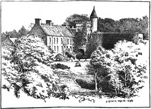
Airlie Castle in Angus, Scotland
Airlie Castle in Angus is a castle (manor house). Airlie Castle is also known as Airlie Castle, Airlie House. Airlie Castle is near Kinnaird Bridge. Ⓦ.
- Building Type
- building
Image
Roads nearby
Bridge of Lundies1,1 km
Bridge of Dillavaird1,6 km
Kinnaird Bridge2,0 km
Lintrathen BridgeBridge Cottage, Bridgend of Lintrathen
2,6 km
Kirkton RoadPrimary School, Kirkton of Airlie, Grange of Airlie, Kirkton of Newtyle, Park View, Kirkton Shops, Cairnie Loan, Aikman Road, Millfield Kitchens & Chinese Takeaway, Kirkton Road, Hunter Road, East Kirkton Road
2,6 km
Baitland Cottages3,0 km
Kaims CottagesAirlie
3,1 km
Bridge of RuthvenRuthven
3,3 km
Body of waters nearby
Duck Pond3,5 km
Buildings nearby
Lintrathen Telephone Exchange2,5 km
Nether Balloch3,7 km
Cafés nearby
Peel Farm3,4 km
Caravan site nearby
Nethercraig Holiday Park2,8 km
Chalet nearby
Square Cottage250 m
Churches nearby
Airlie Old Parish Church2,1 km
Airlie Parish Church2,1 km
Lintrathen Parish Church2,5 km
Farmyards nearby
Barns of Airlie1,8 km
West Craigieloch2,3 km
Meikle Kenny2,3 km
Cairnhall2,5 km
Easter Craig3,0 km
Purgavie Farm3,0 km
Bridgend of Ruthven3,4 km
Milton of Ruthven3,5 km
Carlingwell3,9 km
Forests nearby
Lochcraigs Wood2,3 km
Redmire Wood3,8 km
Selvie Wood4,0 km
Letter Wood4,0 km
Oak Wood4,1 km
Houses nearby
Kirkhill2,6 km
Industrial areas nearby
Airlie Sawmill3,8 km
Meadows nearby
St. Medan's Knowe2,7 km
Nature reserves nearby
Den of Airlie700 m
Places of worship nearby
Ruthven Parish Church3,4 km
Rivers nearby
River Isla3,8 km
Scrublands nearby
Clint Law2,2 km
Streams nearby
Melgam Water1,5 km
Burn of Auchrannie1,6 km
Canty Burn2,1 km
Burn of Quiech3,4 km
Incheoch Burn3,9 km
Baikie Burn3,9 km
Woodlands nearby
Kaims of Airlie2,9 km
Cothelhill Wood3,1 km
East Schurroch4,2 km
Muir of Holm4,3 km
Torrax Hill Wood4,4 km
| Inception | 1432 |
|---|---|
| Heritage designation | category B listed building |
| Located in | Angus, Airlie |
| Country | United Kingdom |
| Body of water | Melgam Water, River Isla |
 Public transport map Angus Legend
| Railway | |
| Bus | |
| Tram |
 Cycling map Angus Legend
| Cycle path | |
| Cycle lane on road | |
| Cycling on bus lane | |
| Bicycle street | |
| Cyclists allowed | |
| Cyclists allowed, good surface | |
| No cycling | |
| Cobblestones |
| Long-distance cycle route | (depending on scale) | |
| Long-distance cycle route |
 Walking map Angus Legend
| Path |
| Long-distance hiking trail | (depending on scale) | |
| Long-distance hiking trail | ||
| No pedestrians |