
Moxy Edinburgh Airport
Moxy Edinburgh Airport in City of Edinburgh is a hotel, Fairview Road 1 (EH28 8AP).
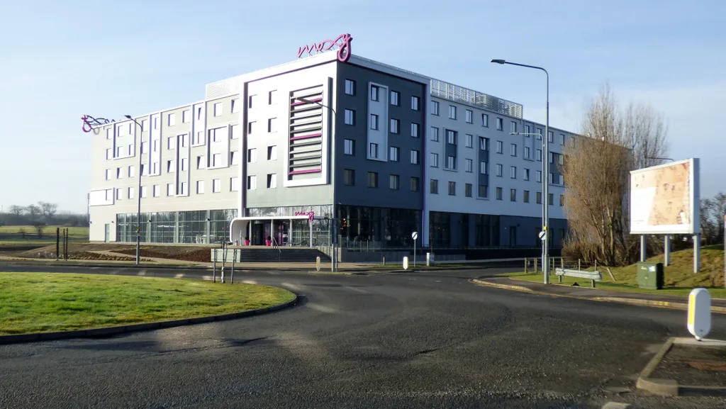
- House Number
- 1
- Postal Code
- EH28 8AP
- Street
- Fairview Road
- Building Type
- hotel
- Operator
- Marriott
- Tourism
- hotel
- Website
- https://www.marriott.co.uk/hotels/maps/travel/ediox-moxy-edinburgh-airport/
Roads nearby
Fairview Road100 m
East Field Avenue150 m
Jubilee Road603 'City of Edinburgh' Squadron Spitfire Memorial, All Bar One, WHSmith, British Airways Lounge, Barburrito, Pret A Manger, Airport (Stance 2), Airport (Stance 3), Airport (Stance 4), Airport (Stance 5), Airport (Stance 6), Airport (Stance 7), Airport (Stance 8), Airport (Stance 9), Airport (Stance 10), Airport (Stance 11), Edinburgh Airport, Avis, Airport (Stance 1), SIXT Car Hire - Edinburgh Airport, Enterprise, Thrifty, Dollar Car Rental, Budget, Tram Lounge, Airport (Stop C), Airport (Stop B), The Sir Walter Scott, Fat Face, Sunglass Hut, Inmotion, Heritage of Scotland, Tartan Weaving Mill, Accessorize, Caffè Nero, Travelex, Luggage Point, Costa, Sainsbury's Local, Krispy Kreme, Starbucks, World Duty Free, Passport Control, Black Sheep Coffee, Airport (Stop D), JD Sports King of Trainers, Airport (Stop E), Airport (Stop H), Airport (Stop F), Airport (Stop G), JD Sports, Fever-Tree Bar, The Bookshop, Brora, The Edinburgh Gift Emporium, Rituals, Boots, Airport (Stop A)
150 m
Eastfield Avenue200 m
Burnside RoadInterrent, Hertz, Europcar
250 m
Almond Drive300 m
Almond Avenue300 m
Gogar Bridge RoadWHSmith, Captain Eric Brown, Europcar, Avis, Caffè Nero
350 m
Almond RoadEdinburgh Supercharger
450 m
Ingliston RoadIngliston Cattery and Kennels, Royal Highland Showground, Gate 5S, Gate 5N
550 m
Eastfield RoadEastfield Road, Green motion car rental, Ingliston, Iskander Aeromedical, Butler's Chauffeur Drive, Airport Hotel
650 m
Glasgow RoadAirport Junction, Airport Roundabout, Gogar Roundabout, Gogarstone Road, Ingliston Road, Ingliston Showground, Middle Norton, Maybury Road (Maybury), Lochend Road, Arnold Clark Accident Repair Centre, Gogar, Gogarburn A8, Gogarburn, North Gyle Road, Craigs Avenue, Craigs Gardens, Bar B Que, Lucky Chen, Smile Plus, Dance Podiatry/Chiropody, Slumdog, St Thomas' Church, Domino's, Cast Iron Grill, Dechmont Road, Clark Commercials, Automak, City Valet, SRS Alloys, Dechmont House, Craigievar Guest House, Station Road
850 m
Masefield Way1,1 km
Turnhouse RoadOld Lennie Schoolhouse, Cargo Terminal, TNT, Turnhouse Farm Road, Meadowfield Road, Meadowfield Farm, West Craigs, Bosch Car Service, Meadowfield Industrial Estate, West Craigs Crescent, Club House, Turnhouse, Maybury Car Sales
1,2 km
LennymuirOld Lennie Schoolhouse
1,2 km
Gogarstone Road1,2 km
Boathouse Bridge1,3 km
Hallyards RoadHallyards, Royal Highland Centre
1,3 km
Freelands Road1,3 km
Amenities nearby
Little Flyers Nursery650 m
Buildings nearby
Ingliston Park and Ride650 m
Buildings nearby
Capital House300 m
pick-up pay-point300 m
Car Rental Centre350 m
Control Post 4450 m
Lowland Hall600 m
Secure Airparks - Airport Parking Edinburgh600 m
Business Aviation Centre650 m
TCR UK EDI700 m
Consolidation Centre1,1 km
Old Lennie Schoolhouse1,2 km
Car hires nearby
EasiRent600 m
Car parks nearby
Airport Short Stay450 m
Commercial areas nearby
Cargo Village1,1 km
Commercial buildings nearby
Spitfire House1,1 km
Convenience stores nearby
M&S Simply Food750 m
Farmhouses nearby
Norton Mains Farm1,1 km
Farmyards nearby
Easter Norton Farm1,0 km
Hangars nearby
Millburn Hangar900 m
Hotels nearby
Hampton by Hilton Edinburgh Airport200 m
Industrial areas nearby
Harrowden Turf450 m
Office buildings nearby
Eastfield House300 m
Railway lines nearby
Edinburgh and Glasgow Main Line1,4 km
Residential buildings nearby
Ingliston House Lodge And Gatepiers700 m
Roof structures nearby
Parking Pay Point500 m
Streams nearby
Gogar Burn850 m
Studios nearby
Sound Sound450 m
Tram stops nearby
Edinburgh Airport450 m
Warehouses nearby
TNT Edinburgh Airport1,2 km
| Located in | Kirkliston |
|---|---|
| Country | United Kingdom |
| Location | Edinburgh Airport |
 Public transport map City of Edinburgh Legend
| Railway | |
| Bus | |
| Tram |
 Cycling map City of Edinburgh Legend
| Cycle path | |
| Cycle lane on road | |
| Cycling on bus lane | |
| Bicycle street | |
| Cyclists allowed | |
| Cyclists allowed, good surface | |
| No cycling | |
| Cobblestones |
| Long-distance cycle route | (depending on scale) | |
| Long-distance cycle route |
 Walking map City of Edinburgh Legend
| Path |
| Long-distance hiking trail | (depending on scale) | |
| Long-distance hiking trail | ||
| No pedestrians |