
Glenfarg Viaduct in Perth and Kinross
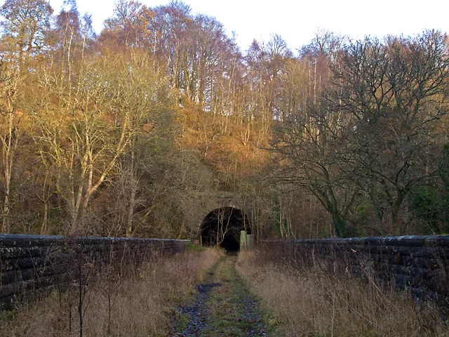
Glenfarg Viaduct in Perth and Kinross is an abandoned railway. It runs in a northeast-southwest direction and ends in a cul-de-sac. Glenfarg Viaduct is also known as Glenfarg, Railway Viaduct.
- Road Type
- track
- Route
- northeast-southwest
Image
Cemetery
Cafés
Car repair shops
Museum
- Museum of Abernethy (web) at School Wynd (PH2 9JJ) – approx. 4,8 km.
Bus stops
Convenience stores
Tourist information offices
Pubs
Car dealerships
Guest house
Roads nearby
Glenfarg South Tunnel400 m
Letham Bridge800 m
Letham RoadForesterseat, Letham Road
1,5 km
Glenfarg North Tunnel1,7 km
Kilknockie Viaduct1,9 km
Millden RoadBalvaird
2,0 km
North Binn Hill2,3 km
Paris Bridge2,3 km
Baiglie Road2,6 km
Marindin Park2,7 km
A9122,8 km
A913Maryland, Aberargie, Front Row, Nethermill, Glenfoot Road
2,8 km
Arngask House RoadArngask
2,9 km
Greenbank Crescent3,1 km
Greenbank Road3,1 km
Main StreetGarage, Kinnesswood, Kinnesswood Shop, The Reading Room, Paterson Place, Church, Hotel, Longforgan, Longforgan Coaching Inn, Longforgan Village Notice Board, Longforgan Village Store, Longforgan Post Office, Slip Road Westbound, Greenburns, Flatfield, Colbeggie, West Ardler, Methven, Methven Arms, Methven Arms Hotel, Stop & Shop Express, Oak Room Restaurant, Duncan's Tools & Fixings, Golden City Chinese Take-Away, Lawson's Garage, Chatni, Davidsons Chemists, The Little Acorn Cafe, Ladeside, Balhomie, Gleninsheen, Byres, Balajee Spice, Kwik Fit, Bridgend Court, Signs & Designs, Richard Allan Photography, Unique, Clip Joint, Crook of Devon Post Office, Hepburn Motors, Lochty, The Little Hair Company, Perth Dog Training, S.M.A.R.T. Repairs, The Corn Kist, Almondbank Post Office, Lochty Welders LP, Mylnefield Road, Carselea Road, Scotmid, Azaad, Invergowrie Model Centre, Boots, Fraser Graeme, Post House Deli Co, The Post House Coffee Co, Invergowrie Dental Practice, Bankfoot Inn, Bankfoot, Nisa, Greenbank Road, Station Road, Eastbank Place, Invergowrie Inn, All Souls' Church Parking, Greystane Road, Fat Joe's, Smile Design, MaMa's, Friend's Barber, The Bridgend Inn, Rosebank Cottage, Abernethy Licensed Store, The Inn
3,2 km
Buildings nearby
Blairstruie1,6 km
Brampton House1,9 km
Scarrhill Cottages2,0 km
Balvaird Castle2,2 km
Beautyfield House2,2 km
Ayton2,6 km
Balmanno Castle2,7 km
Cemeteries nearby
Arngask Cemetery2,9 km
Community centres nearby
Glenfarg Community Centre3,2 km
Farmyards nearby
Meikle Fieldie600 m
Easter Fordel1,3 km
Kilknockiebank2,0 km
Conland2,2 km
Lochelbank2,3 km
Balmanno2,5 km
Wester Fordel2,6 km
Ayton Farm2,7 km
East Dron3,1 km
Forests nearby
North Wood2,5 km
Houses nearby
Easter Fordel Cottage1,3 km
Blairstruie Cottage1,3 km
Pubs nearby
Bein Inn550 m
The Baiglie Inn2,7 km
Razed railways nearby
Cowdenbeath Junction to Bridge of Earn Line1,6 km
Residential areas nearby
Clochridgestane950 m
Glenfarg3,0 km
Streams nearby
Fildie Burn800 m
Baiglie Burn2,0 km
River Farg2,8 km
Dron Burn2,8 km
Wood Burn3,0 km
Woodlands nearby
Kennel Wood2,3 km
Fordel Wood2,6 km
| Located in | Perth and Kinross, Dron |
|---|---|
| Country | United Kingdom |
| Crosses | River Farg, B996 road |
| Carries thoroughfare | Glenfarg Line |
 Public transport map Perth and Kinross Legend
| Railway | |
| Bus | |
| Tram |
 Cycling map Perth and Kinross Legend
| Cycle path | |
| Cycle lane on road | |
| Cycling on bus lane | |
| Bicycle street | |
| Cyclists allowed | |
| Cyclists allowed, good surface | |
| No cycling | |
| Cobblestones |
| Long-distance cycle route | (depending on scale) | |
| Long-distance cycle route |
 Walking map Perth and Kinross Legend
| Path |
| Long-distance hiking trail | (depending on scale) | |
| Long-distance hiking trail | ||
| No pedestrians |