
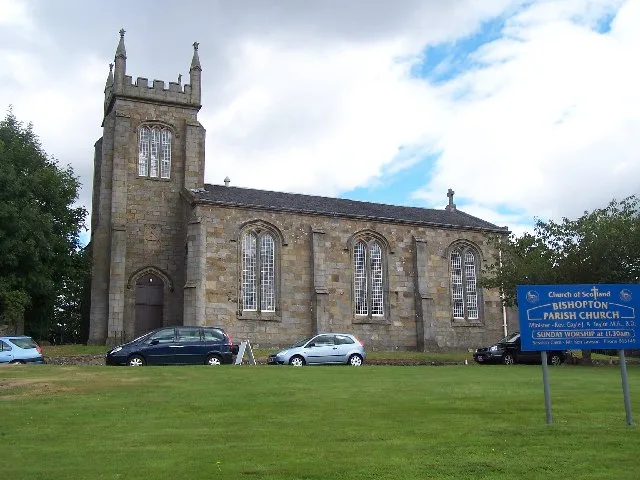
Bishopton Parish Church in Renfrewshire
Bishopton Parish Church in Renfrewshire is a church. It is near Drumcross Road and is a listed building.
- Amenity
- place of worship
- Building Type
- church
Image
Places of worship
Pharmacy
Stations
Fast food restaurants
Bus stops
Hairdressers
ATMs
Post offices
Cafés
Convenience stores
Dentist
Pubs
Roads nearby
Mar Hall Avenue550 m
Ferry Road550 m
Drumcross Road600 m
North Porton Road600 m
Princes Park750 m
McCallum Way800 m
Nursery Avenue800 m
Queens Drive850 m
Veteranes Cottages900 m
Toll Plaza InterchangeToll Plaza Interchange
900 m
Redwood Crescent900 m
Shaw Avenue950 m
Lang Avenue950 m
Mar Avenue950 m
Burns Avenue950 m
Kingston Road1000 m
Semple Avenue1000 m
Cameron Avenue1000 m
Lamont Avenue1000 m
Lennox Avenue1000 m
Hay Avenue1,0 km
Chisholm Avenue1,0 km
Stuart Road1,0 km
Leslie Avenue1,0 km
Laighpark Avenue1,0 km
Old Greenock RoadInchinnan, Balmoral Crescent, Broomlea Crescent
1,1 km
Devon Drive1,1 km
Dunglass Road1,1 km
Wallace Avenue1,1 km
Camphill Gardens1,1 km
Etive Drive1,1 km
Kingston Grove1,2 km
Carron Drive1,2 km
Renshaw Road1,2 km
Shilton Lane1,3 km
Yarrow Crescent1,3 km
Morar Crescent1,3 km
Sempill Avenue1,3 km
Buildings nearby
Hewlett Packard Enterprise300 m
Golf courses nearby
Erskine Golf Club600 m
Earl of Mar Golf Course1,1 km
Hotels nearby
Mar Hall Hotel800 m
Industrial buildings nearby
Scotland's Bravest Manufacturing Company800 m
Pigsties nearby
Erskine House piggery750 m
Retail areas nearby
Caulders Garden Centre900 m
School buildings nearby
Happitots Nursery850 m
Service buildings nearby
Reid Macewan Activity Centre700 m
Social facilities nearby
David Boyle Court800 m
Woodlands nearby
Big Wood700 m
| Heritage designation | category B listed building |
|---|---|
| Located in | Renfrewshire, Erskine |
| Country | United Kingdom |
 Public transport map Renfrewshire Legend
| Railway | |
| Bus | |
| Tram |
 Cycling map Renfrewshire Legend
| Cycle path | |
| Cycle lane on road | |
| Cycling on bus lane | |
| Bicycle street | |
| Cyclists allowed | |
| Cyclists allowed, good surface | |
| No cycling | |
| Cobblestones |
| Long-distance cycle route | (depending on scale) | |
| Long-distance cycle route |
 Walking map Renfrewshire Legend
| Path |
| Long-distance hiking trail | (depending on scale) | |
| Long-distance hiking trail | ||
| No pedestrians |