
The Nag's Head in Haughton, Cheshire
The Nag's Head in Cheshire East, Haughton is a pub, Long Lane (CW6 9RN) 🌐. The Nag's Head also exists in Hertfordshire, Norfolk, Shropshire, City of Milton Keynes and Leicestershire.
- Postal Code
- CW6 9RN
- Street
- Long Lane
- Amenity
- pub
- Building Type
- building
- Website
- https://www.nagsheadhaughton.com/
Image
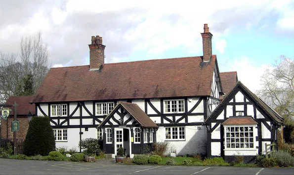
Caravan site
Roads nearby
Ferret Oak LaneHaughton, Long Lane / Hall Lane
600 m
Cappers LanePear Tree Farm
650 m
Long LaneHaughton, Long Lane / Nag's Head PH, Haughton, Rookery Cottage
650 m
Haughton Hall LaneRadmore Green, Hall Lane / Yew Tree Farm, Haughton, Hall Lane / Haughton Hall
1,5 km
Birds Lane1,5 km
Dob Lane1,5 km
Badcocks LaneSpurstow, Badcock's Lane / Long Lane, Spurstow, Badcock's Lane / Fields Farm
1,6 km
Brindley Hall RoadBrindley, Brindley Hall Road / Brindley Lea Lane
2,0 km
St. Boniface Road2,0 km
Wyche Lane2,0 km
Hill Close2,1 km
Tweddle Close2,1 km
Grange Close2,1 km
Hurst Court2,2 km
Hurst Close2,2 km
Wyche Road2,2 km
Orchard Close2,2 km
Bowes Gate RoadBunbury, Bowe's Gate Road / Bunbury Common, Bunbury, Bowe's Gate Road / St Boniface's Church
2,3 km
Vicarage Lane2,3 km
Attraction nearby
Bunbury Mill2,1 km
Buildings nearby
Salt House1,3 km
Garners Farm1,4 km
Woodworth Green Farmhouse1,5 km
Radmore Green Farm1,6 km
Brindley Hall Farm1,7 km
High Ash Farm1,8 km
Lawn Bowls2,2 km
Farmyards nearby
Moss Farm350 m
Cappers Lane Farm700 m
Houses nearby
Oak Farmhouse100 m
Mayfield House550 m
The Old School House650 m
Green Cottage700 m
Haughton Hall800 m
Spurstow Hall1,2 km
Spurstow Hall Cottages1,3 km
The Bath House1,3 km
Coxey Green Farm1,4 km
Lower Hall Cottage1,5 km
Ivy Cottage1,6 km
Radbrook Cottage1,8 km
Bunbury Millhouse2,1 km
Chantry House2,2 km
Birchfield2,2 km
Church Bank Cottage2,3 km
Places of worship nearby
St Boniface2,3 km
Sports pitches nearby
Bunbury Crown Green Bowls Club2,2 km
Streams nearby
River Gowy2,2 km
Woodlands nearby
Spa Plantation1,3 km
| Heritage designation | Grade II listed building |
|---|---|
| Located in | Haughton |
| Country | United Kingdom |
 Public transport map Haughton Legend
| Railway | |
| Bus | |
| Tram |
 Cycling map Haughton Legend
| Cycle path | |
| Cycle lane on road | |
| Cycling on bus lane | |
| Bicycle street | |
| Cyclists allowed | |
| Cyclists allowed, good surface | |
| No cycling | |
| Cobblestones |
| Long-distance cycle route | (depending on scale) | |
| Long-distance cycle route |
 Walking map Haughton Legend
| Path |
| Long-distance hiking trail | (depending on scale) | |
| Long-distance hiking trail | ||
| No pedestrians |