
Holy Trinity in Whaley Bridge
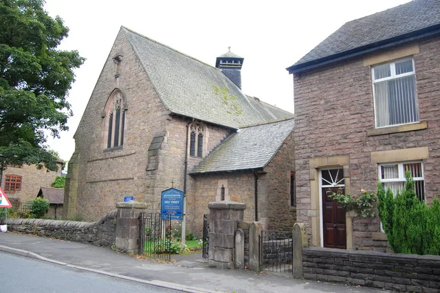
Holy Trinity in Whaley Bridge in High Peak is a Anglicana church. It is near Japanese Garden and is also known as Holy Trinity Church and attached rear boundary wall. The church belongs to the Diocese of Chester and is dedicated to Holy Trinity. It is a listed building. Holy Trinity also exists in Derbyshire Dales and Bolsover.
- Amenity
- place of worship
- Building Type
- church
Image
Specialist shops
Post offices
Hairdressers
Pet groomings
Clothing shops
Pet shops
Bus stops
Kindergarten
Bar
Fast food restaurants
Beauty salons
Social facility
Art galleries
Antique shops
Car repair shops
Weapons shops
Roads nearby
Linear Park100 m
Wheatsheaf Road150 m
Wheatsheaf Close150 m
Wheatsheaf Cottages150 m
Goyt Road150 m
Turner's Corner200 m
The Owlers200 m
Chapel RoadWhaley Bridge, Chapel Road / adjacent Ollerenshaw Cottages, Whaley Bridge, Chapel Road / adjacent Cadster Farm, Whaley Bridge, Chapel Road / opposite Cadster Farm, Whaley Bridge, Chapel Road / opposite Ollerenshaw Cottages, Whaley Bridge, Chapel Road / adjacent Old Road, Whaley Bridge, Buxton Road / adjacent Board Inn, Whaley Bridge, Chapel Road / opposite Old Road, Welcome to Whaley Bridge
250 m
Lower Macclesfield RoadWhaley Bridge Lower Macclesfield Road, Handmade in Horwich End
250 m
Park RoadHorwich End
300 m
Japanese Garden300 m
Botany Mews300 m
Buxton RoadJack Hallam and Sons, Whaley Bridge, Buxton Road / opposite Primary School, Primary School, Into The Skin, Over The Road, Raw Pawz, Ivie & Luxe, Ruby's Bar & Kitchen, Sunshine Nursery School, Furness Vale, Buxton Road / opposite Crescent Drive, Furness Vale, Buxton Road / opposite Soldier Dick, Furness Vale, Buxton Road / adjacent Dale Farm Dairy, The Chip Box, Furness Vale, Furness Vale, Buxton Road / opposite St Johns Church, Furness Vale, Buxton Road / opposite Primary School, Furness Vale, Buxton Road / opposite Hollins View, Furness Vale, Buxton Road / adjacent Crescent Drive, Furness Vale, Buxton Road / adjacent Hollins View, Furness Vale, Buxton Road / adjacent Soldier Dick, Furness Vale, Buxton Road / opposite Dale Farm Dairy, Furness Vale, Buxton Road / adjacent St Johns Church, Giovanni, Lizzies, Horwich End Post Office, Frydays, Horwich End opposite White Horse, Horwich End after White Horse, High Peak CVS, Welcome to Whaley Bridge, Tuck Inn, Bridgemont, Whaley Bridge, Buxton Road / adjacent Bridgemont, Whaley Bridge, Buxton Road / opposite Bridgemont
300 m
Forge RoadHi-Press Hydraulics Ltd, Whaley Bridge Garage
300 m
Macclesfield Road300 m
Reddish Road350 m
Wharf Court400 m
Wharf RoadWhaley Bridge Library, Halo Beauty
450 m
The Masons450 m
Reservoir RoadHistoric Valve, Brookfield Pond, Ikram, The Railway, Whaley Bridge
500 m
Orchard Avenue550 m
Shops nearby
Peak 3D200 m
Abandoned railways nearby
Cromford and High Peak Railway100 m
Body of waters nearby
Brookfield Pond500 m
Buildings nearby
Clover Chemicals Ltd300 m
Car repair shops nearby
Torqlogic200 m
Autotech Service Centre300 m
Civic buildings nearby
Whaley Hall550 m
Commercial buildings nearby
Gisbourne House300 m
Gisbourne Works300 m
Drains nearby
Canal Feeder150 m
Overflow #2400 m
Colliery Drain400 m
Canal Feeder #2400 m
Outlet #2400 m
Canal Feeder #1400 m
Overflow #1400 m
Outlet #1450 m
Peak Forest Canal Feeder500 m
Hardware shops nearby
Walker & Howell Ltd350 m
Meadows nearby
Cow Field350 m
Nature reserves nearby
Brookfield Pond Nature Reserve450 m
Office buildings nearby
Dunbar House Business Centre100 m
Parks nearby
Memorial Park300 m
Pubs nearby
The Cock200 m
Railway lines nearby
Buxton Line350 m
Sports centres nearby
Toddbrook Sailing Club450 m
Sports pitches nearby
Whaley Bridge Crown Green Bowls Club200 m
Whaley Bridge Skateboard and Cycle Park200 m
| Dedicated to | Holy Trinity |
|---|---|
| Diocese | Diocese of Chester |
| Heritage designation | Grade II listed building |
| Located in | Whaley Bridge |
| Country | United Kingdom |
 Public transport map Whaley Bridge Legend
| Railway | |
| Bus | |
| Tram |
 Cycling map Whaley Bridge Legend
| Cycle path | |
| Cycle lane on road | |
| Cycling on bus lane | |
| Bicycle street | |
| Cyclists allowed | |
| Cyclists allowed, good surface | |
| No cycling | |
| Cobblestones |
| Long-distance cycle route | (depending on scale) | |
| Long-distance cycle route |
 Walking map Whaley Bridge Legend
| Path |
| Long-distance hiking trail | (depending on scale) | |
| Long-distance hiking trail | ||
| No pedestrians |