
St Barnabas Church in Borough of Broxtowe
St Barnabas Church in Broxtowe is a Anglicana church, Barn Croft (NG9 4HU). It belongs to the Diocese of Southwell and Nottingham and is dedicated to Barnabas. Ⓦ.
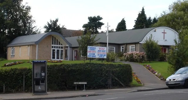
- Postal Code
- NG9 4HU
- Street
- Barn Croft
- Amenity
- place of worship
- Building Type
- church
- Website
- https://www.stbarnabas-inhamnook.co.uk/
Roads nearby
Hoggetts Close100 m
Barn Croft100 m
Inham RoadOak Acres, Great Hoggett Drive, Blandford Road, Wentworth Road, Valley Road, Inham Nook Library, Inham Nook
100 m
Great Hoggett Drive150 m
Patient Close150 m
Oak Acres150 m
Wheatgrass Road150 m
Pearson Close200 m
Hawker Close200 m
Slade Road250 m
Meer Road250 m
Marriott Close250 m
The Flatts250 m
Cresswell Road300 m
Southfields Court300 m
Pearson Avenue300 m
Camdale Close350 m
Wentworth Road450 m
Nursery Avenue500 m
Orton Fields500 m
Orton Avenue550 m
The Copse550 m
Common Lane550 m
Inham Circus550 m
Beaufort Drive600 m
Chilwell LaneAlderman White School, Chilwell Lane
650 m
Sunnyside RoadSunnyside Post Office
700 m
Linkin Road700 m
Siskin Close700 m
Bramwell Drive750 m
Hall Gardens750 m
Kingsbridge Way750 m
Fieldfare Close800 m
Baxter Green800 m
Peache Way800 m
Allotment gardens nearby
Inham Nook Allotments400 m
Buildings nearby
Drama Block800 m
Community centres nearby
Chilwell Community Centre100 m
Convenience stores nearby
Deepak Foodstore100 m
Spar550 m
Bramcote Lane Convenience Stores700 m
Fast food restaurants nearby
Evergreen550 m
Sollaa550 m
School buildings nearby
Main Reception700 m
Music Block700 m
Main Block750 m
Sports Hall800 m
Social facilities nearby
Chetwynd House Care Home200 m
Chilwell Sure Start Children's Centre250 m
| Dedicated to | Barnabas |
|---|---|
| Diocese | Diocese of Southwell and Nottingham |
| Located in | Broxtowe |
| Country | United Kingdom |
 Public transport map Broxtowe Legend
| Railway | |
| Bus | |
| Tram |
 Cycling map Broxtowe Legend
| Cycle path | |
| Cycle lane on road | |
| Cycling on bus lane | |
| Bicycle street | |
| Cyclists allowed | |
| Cyclists allowed, good surface | |
| No cycling | |
| Cobblestones |
| Long-distance cycle route | (depending on scale) | |
| Long-distance cycle route |
 Walking map Broxtowe Legend
| Path |
| Long-distance hiking trail | (depending on scale) | |
| Long-distance hiking trail | ||
| No pedestrians |