
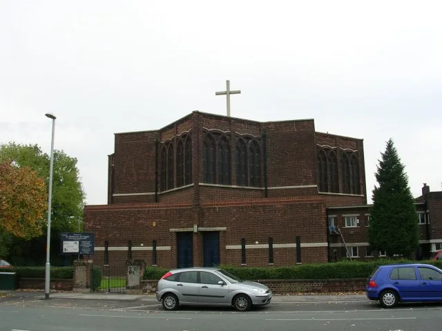
St Michael & All Angels in City of Manchester
St Michael & All Angels in Manchester is a Anglicana church. It is near Baycroft Grove and belongs to the Anglican Diocese of Manchester. The church is dedicated to Michael and is a listed building. St Michael & All Angels also exists in Wigan. Ⓦ.
- Amenity
- place of worship
- Building Type
- church
Image
Roads nearby
Nightingale Gardens50 m
Kerne Grove150 m
Leycett Drive150 m
Orton Avenue150 m
Orton RoadWythenshawe Community Café, Northern Moor, Orton Road / adjacent Sale Road, Northern Moor, Orton Road / near Moorcroft Road
150 m
Woodbridge Grove200 m
Heys Avenue200 m
Brows Avenue250 m
Lawton Moor Road250 m
Boxhill Drive250 m
Baycroft GroveNorthern Moor
300 m
Tours Avenue300 m
Moor Lane300 m
Hillend Road350 m
Hillend Place350 m
Northolt Road400 m
Fellpark Road400 m
Surtees Road450 m
Mossdale Road450 m
Brent Road450 m
Cleeve Road450 m
Button Lane500 m
Brenchley Drive500 m
Wisbech Drive500 m
Moorcroft RoadNorthern Moor, Moorcroft Road / near Garthorp Road, Northern Moor, Moorcroft Road / outside The Park Hotel, Northern Moor, Moorcroft Road / near Mossdale Road, Northern Moor, Moorcroft Road / opposite Mossdale Road, Northern Moor, Moorcroft Road / opposite Button Lane, Northern Moor, Moorcroft Road / near Button Lane, Northern Moor, Moorcroft Road / near Orton Road, Tesco Express
550 m
Sealand Road550 m
Feldom Road550 m
Wythenshawe RoadNorthern Moor, Wythenshawe Road / near Orton Road, Northern Moor, Wythenshawe Road / opposite Orton Road, Northern Moor, Wythenshawe Road / opposite Carloon Road, Wythenshawe Road/Carloon Road, Northern Moor, Wythenshawe Road / opposite Rackhouse Road, Northern Moor, Wythenshawe Road / near Northolt Road, Northern Moor, Wythenshawe Road / opposite Northolt Road, St Aidan's Church, Northern Moor, Wythenshawe Road / near Carloon Road, Northenden, Princess Parkway / Britannia Hotel (Stop D), Brooklands, Wythenshawe Road / opposite Briarwood Avenue, Northern Moor, Wythenshawe Road / near Warmley Road, Northern Moor, Wythenshawe Road / Wythenshawe Park Metrolink Stop, Northern Moor, Wythenshawe Road / opposite Warmley Road, Northern Moor, Wythenshawe Road / near Rackhouse Road, Wythenshawe Park, The Gardeners Arms, Northenden, Wythenshawe Road / Princess Parkway (Stop C), Northern Moor, Wythenshawe Road / near Briarwood Avenue
550 m
Woodham Road550 m
Alfriston Drive550 m
Sale RoadNorthern Moor, Sale Road / Northern Moor Metrolink Stop, Sale Road/Cleeve Road, Northern Moor, Sale Road / near Orton Road, Northern Moor, Sale Road / near Brenchley Drive, Northern Moor, Sale Road / Northern Moor Metrolink (Stop B), Northern Moor, Sale Road / near Cleeve Road, Northern Moor, Sale Road / near Shevington Gardens, Northern Moor, Sale Road / at Sale Circle, Northern Moor, Sale Road / near Rackhouse Road, Northern Moor, Sale Road / adjacent Rackhouse Road, Sale Road/Shevington Gardens, Northern Moor, Sale Road / adjacent Sale Circle, Northern Moor, Sale Road / near Yew Tree Lane, Nisa Local, Northern Moor, Sale Road / opposite Shevington Gardens, Sale Circle Post Office
550 m
Rathmel Road600 m
Hawkswick Drive600 m
Greenham Road600 m
Melsomby Road650 m
Kelfield Avenue650 m
Healey Close650 m
Kerscott RoadNorthern Moor
700 m
Beauty salons nearby
Solaris550 m
Buildings nearby
St Michael's Community Hall50 m
Convenience stores nearby
RajaBros550 m
Fast food restaurants nearby
Sam's550 m
J's Rhythm550 m
Hairdresser's nearby
Danny Wright's550 m
Light rail lines nearby
Metrolink700 m
Places of worship nearby
Lawton Moor Methodist Church450 m
Residential buildings nearby
Caretaker's House500 m
School buildings nearby
Button Lane Primary School450 m
Tram stops nearby
Northern Moor700 m
| Dedicated to | Michael |
|---|---|
| Diocese | Anglican Diocese of Manchester |
| Heritage designation | Grade II* listed building |
| Located in | Manchester |
| Country | United Kingdom |
| Website | https://web.archive.org/web/20200414174031/https://www.wythenshawe-anglican.org/stmichaels.html |
 Public transport map Manchester Legend
| Railway | |
| Bus | |
| Tram |
 Cycling map Manchester Legend
| Cycle path | |
| Cycle lane on road | |
| Cycling on bus lane | |
| Bicycle street | |
| Cyclists allowed | |
| Cyclists allowed, good surface | |
| No cycling | |
| Cobblestones |
| Long-distance cycle route | (depending on scale) | |
| Long-distance cycle route |
 Walking map Manchester Legend
| Path |
| Long-distance hiking trail | (depending on scale) | |
| Long-distance hiking trail | ||
| No pedestrians |