
St John's in Metropolitan Borough of Wigan
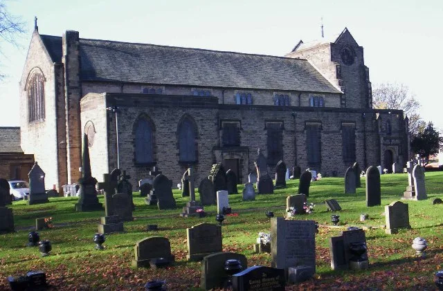
St John's in Wigan is a Anglicana church. It is near Kirkham Street and is also known as Church of St John the Evangelist, Abram. The church belongs to the Anglican Diocese of Liverpool and is dedicated to John the Evangelist. It is built in the Gothic Revival style. St John's also exists in Salford and Stockport. Ⓦ.
- Amenity
- place of worship
- Building Type
- church
Image
Roads nearby
Warrington RoadWarrington Road/Simpkin Street, Warrington Road/Bickershaw Lane, Warrington Road/Alexandra Street, Warrington Road/Crankwood Road, Warrington Road/School Street, Warrington Road/Abram Council Offices, Warrington Road/Abram Post Office, Warrington Road/Park Lane, Warrington Road/Abram Labour Club, Fortune Cookie, Warrington Road/Motorway Junction, Screwfix, Warrington Road/Central Avenue, Warrington Road/Hope Carr Road, Warrington Road/Archer Street, Warrington Road/Hope Carr Lane, Jackbits, Sunny House, Warrington Road/Millers Lane, Super Fade Cut, Betfred, Warrington Road/Dover Lock, Warrington Road/Redbrook Road, Warrington Road/Frederick Street, Warrington Road/Golf Course, Warrington Road/Tyrer Avenue, Warrington Lane/Orrell Street, Warrington Road/Bay Horse, Warrington Road/St Thomas Church, BeautyFull Bathrooms, Ashton Cycles, Nutters, Formula One Autocentres, Warrington Road/Marus Bridge Retail Park, Fire Station, Warrington Road/Stanley Street, Warrington Road/Alexandra Park, Warrington Road/Little Lane, Warrington Road/Clap Gate Lane, Warrington Road/Cemetery Road, Warrington Road/Ince Green Lane, Warrington Road/Coronation Street, Warrington Road/Taylors Lane, Warrington Road/Marlborough Avenue, Byrchall High School Grounds, Warrington Road/St Edmund Arrowsmith, Warrington Road/East Lancs Road, Warrington Road/Poolstock Lane, InPost, Amazon Locker, Infinity Hair, Home to Roost, Warrington Road/St Pauls Avenue, Warrington Road/Haydock Park, Warrington Road/Lower Ince, Arches, Pall Mall Carpets
100 m
Kirkham Street100 m
Saint John's Street100 m
Langdale Crescent150 m
Atkinson Street200 m
Minstrel Close200 m
Rydal Place200 m
Grasmere Terrace200 m
Camm Street200 m
Egerton Street200 m
Stephenson Street300 m
Alexandra Street300 m
Grimshaw Park300 m
Wright Street300 m
Whitley CrescentWhitley Crescent/Spencer Road
300 m
Kingsdown Road350 m
Coniston Drive350 m
Ansford Avenue350 m
Thirlmere AvenueThirlmere Avenue/Petticoat Lane
350 m
Windermere RoadWindermere Road/Langdale Avenue, Windermere Road/Ambleside, Leigh Central Startwell Link, Leigh Central Primary School
350 m
Mason Street350 m
Verda Street350 m
Lee Lane400 m
Vicarage Gardens400 m
Park ViewToolstation, One Stop
400 m
Lawrence Court450 m
Greenoak Close450 m
Stable NookWarrington Road/School Street
500 m
School StreetSams Bar
500 m
St John's Court500 m
Beauty salons nearby
The Sister Studios250 m
Buildings nearby
Abram Village Club150 m
Abram WWPS250 m
Canals nearby
Leeds and Liverpool Canal (Leigh Branch)300 m
Chemist's nearby
Abram Pharmacy350 m
Clinics nearby
Health First400 m
Commercial buildings nearby
FX Signs and Designs400 m
Community centres nearby
Abram Community Centre550 m
Convenience stores nearby
Abram Village Convenience Store150 m
Fast food restaurants nearby
The Rainbow150 m
Box Kitchen400 m
Gardens nearby
Abram Centenary Garden100 m
Hairdresser's nearby
Alema Hair and Beauty100 m
Richies Salon400 m
Post offices nearby
Abram Post Office200 m
Pubs nearby
The Bucks Head100 m
Recreation grounds nearby
St John's Street Playing Fields150 m
Residential buildings nearby
Maypole Hall100 m
Stables nearby
Abram Hall Riding Centre400 m
| Architectural style | Gothic Revival |
|---|---|
| Dedicated to | John the Evangelist |
| Diocese | Anglican Diocese of Liverpool |
| Located in | Wigan |
| Country | United Kingdom |
 Public transport map Wigan Legend
| Railway | |
| Bus | |
| Tram |
 Cycling map Wigan Legend
| Cycle path | |
| Cycle lane on road | |
| Cycling on bus lane | |
| Bicycle street | |
| Cyclists allowed | |
| Cyclists allowed, good surface | |
| No cycling | |
| Cobblestones |
| Long-distance cycle route | (depending on scale) | |
| Long-distance cycle route |
 Walking map Wigan Legend
| Path |
| Long-distance hiking trail | (depending on scale) | |
| Long-distance hiking trail | ||
| No pedestrians |