
St Thomas in Metropolitan Borough of Wigan
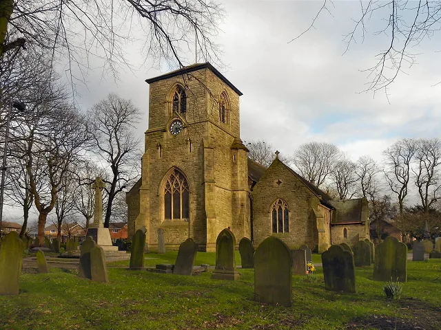
St Thomas in Wigan is a Anglicana church, Church Street (WA3 3TH). It is also known as St Thomas' Church, Golborne and belongs to the Anglican Diocese of Liverpool. The church is a listed building. St Thomas also exists in Tameside, Salford, Stockport, Oldham and Rochdale.
- Postal Code
- WA3 3TH
- Street
- Church Street
- Amenity
- place of worship
- Building Type
- church
Image
Roads nearby
Church StreetStandish Mining Sculpture, The Lychgate, Orrell, Church Street/Orrell Station (Stop A), Church Street/Church Drive, Well Pharmacy, Church Street Dental Practice, Orrell Curry House, La Orient, The Old Bank, Church Street/Manor Street, Red Lion, Leigh Carpet Co
100 m
Church Green Gardens150 m
Gloucester Avenue150 m
Church Street Gardens150 m
Cottesmore Way200 m
High StreetHigh Street/Railway Road, High Street/John Street (Stop D), High Street/John Street (Stop C), High Street/Alder Street, Central Methodist Church, UK Tyres, Elliotts, High Street/Police Station, Bang and Loop, Impressions, Clear Ears, Standish, Standish Brows and Beauty Bar, Ajmeer Manzil, Tim's La Mama, Chic Interiors, Valletta, Natural Nurse Aesthetics, Global Travel, Lucy Lou's Balloons, Albion Ale House, Petite Boutique, Natasha's Beauty Bar, Humble Pie Cafe, Turkish Hairlines, Changing Rooms Standish, Got 2 Travel, Bridge Street/School Street
200 m
Hereford Avenue200 m
Manor StreetChurch Street Chippy, Well Pharmacy
200 m
Wilsford Close250 m
Elliott Avenue250 m
Tewkesbury Road250 m
Heywood Avenue250 m
West Avenue250 m
Knowsley Avenue300 m
Poplar Street300 m
Worcester Avenue300 m
Ivy Road300 m
Short Street350 m
Hazel Grove350 m
Lowton RoadLowton Road/Church Street, Lowton Road/Golborne High School, Lowton Road/The Horns Inn, Lowton Road/Windsor Road
400 m
East Avenue400 m
Rothwell Gardens400 m
Naylor Avenue400 m
Barwell Close400 m
Barrowdale Road450 m
Oak Avenue450 m
Nook LaneNook Lane/Barrowdale Road, Nook Lane/Derby Road
450 m
Briar Road500 m
Derby RoadAM To PM Convenience Store, The Tanning Rooms, Derby Road/East Avenue, Derby Road/Naylor Avenue, Derby Road/Manor Avenue
500 m
Ash Grove550 m
Beauty salons nearby
Blush, Brown, Laser250 m
Buildings nearby
Golborne St Thomas Scout & Guide HQ100 m
Golborne Clinic300 m
Bungalows nearby
Heywood Gardens350 m
Churches nearby
Gospel Hall250 m
Convenience stores nearby
Hooton's250 m
Doctor's practice nearby
Kid Glove House200 m
Farmhouses nearby
Stackhouse Farm450 m
Fast food restaurants nearby
Aroma250 m
Wok's Cooking250 m
Gardens nearby
Garden feature400 m
Industrial areas nearby
Golborne Industrial Park150 m
Industrial buildings nearby
Wetherby150 m
PHS Compliance200 m
R & M Courier Services250 m
Kitchen showrooms nearby
PlanAHome250 m
Parks nearby
Heywood Park200 m
Railway lines nearby
West Coast Main Line100 m
Terraced houses nearby
The Poplars250 m
| Diocese | Anglican Diocese of Liverpool |
|---|---|
| Heritage designation | Grade II listed building |
| Located in | Wigan |
| Country | United Kingdom |
| Location | Wigan |
 Public transport map Wigan Legend
| Railway | |
| Bus | |
| Tram |
 Cycling map Wigan Legend
| Cycle path | |
| Cycle lane on road | |
| Cycling on bus lane | |
| Bicycle street | |
| Cyclists allowed | |
| Cyclists allowed, good surface | |
| No cycling | |
| Cobblestones |
| Long-distance cycle route | (depending on scale) | |
| Long-distance cycle route |
 Walking map Wigan Legend
| Path |
| Long-distance hiking trail | (depending on scale) | |
| Long-distance hiking trail | ||
| No pedestrians |