
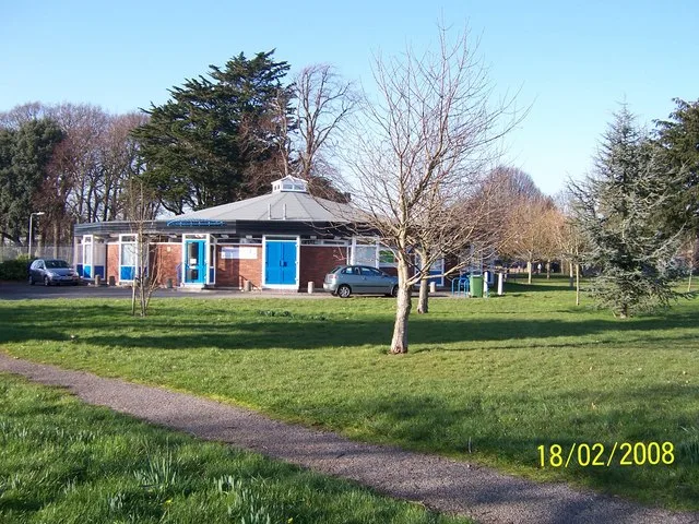
Stubbington Library in Borough of Fareham
Stubbington Library in Fareham is a library (opening hours: Mo 09:00-19:00; Tu 09:00-17:00; We closed; Th-Fr 09:00-17:00; Sa 09:30-13:00; Su closed), Stubbington Lane (PO14 2PP) 🌐.
- Postal Code
- PO14 2PP
- Street
- Stubbington Lane
- Amenity
- library
- Building Type
- building
- Website
- https://www3.hants.gov.uk/library/stubbington-library.htm
Image
Bakeries
Florist's
Restaurants
Off-licences
Pubs
Bus stops
School
Shelter
Post offices
Convenience stores
Dentist
Charity shops
Roads nearby
Stubbington LaneBells Lane Junction, William Close, Golden Bowler, Seamead
100 m
Village Close150 m
Crofton Court150 m
Stubbington GreenThe Bakers, Stubbington, Stubbington Green Dental Practice, Morrisons Daily, Grandé Wines, The Stubbington Tandoori, Bloom, Sue Ryder, Stubbington Post Office, Stubbington Village
200 m
Croftlands Avenue250 m
Park LaneColenso Road, Mobility Scooter shelter, Fareham Leisure Centre
300 m
Cutlers LaneCrofton Club
300 m
Gosport RoadPeel Common, Harold Road, Crofton School, West Gate, Alders Road, The Quay, Town Quay, Upper Quay, Esso, Earls Road, Spar, Greggs, Mill Road, Cams Alders, Hoeford, White House, Marks Road
300 m
Angelus Close300 m
Mays LaneSumar Close, St Marys Road, Ditton Close
300 m
Glyn Drive350 m
Longs Lane350 m
Halletts Close350 m
Bells LaneBells Lane, Mancroft Avenue
400 m
Cains Close450 m
Rectory Close450 m
Robins Close450 m
Ditton Close500 m
Canterbury Road550 m
Vicarage Lane550 m
Cuckoo LaneCuckoo Pint, Old Street, Tawny Owl Close, Jay Close
550 m
Deal Close600 m
Beauty salons nearby
Innovation Hair And Beauty150 m
Buildings nearby
Stubbington Telephone Exchange200 m
Cafés nearby
Costa150 m
The Great & Tasty250 m
Carpet shops nearby
Stubbington Carpets400 m
Charity shops nearby
Rowans Hospice250 m
Doctor's practice nearby
Stubbington Medical Practice150 m
Fast food restaurants nearby
Domino's150 m
New Silver River200 m
Frozen food shops nearby
Iceland200 m
Garden centres nearby
Parker’s250 m
Gift shops nearby
Forget Me Not200 m
Newsagent's nearby
Martin's250 m
Pet shops nearby
Village Pets250 m
Pharmacies nearby
Village Pharmacy150 m
Places of worship nearby
The Immaculate Conception250 m
Pubs nearby
The Red Lion150 m
Crofton Working Mens Club350 m
Recreation grounds nearby
Stubbington Recreation Ground200 m
Roof structures nearby
War Memorial200 m
Sports centres nearby
Crofton Community Centre150 m
Sports pitches nearby
Crofton Tennis Club100 m
Crofton Bowling Club150 m
Supermarkets nearby
The Co-operative Food150 m
Veterinary practices nearby
Alver Veterinary Group250 m
Other nearby
Stubbington Substation350 m
Ditton Close Substation450 m
| Elevation | 12.2 m |
|---|---|
| Operator | Hampshire County Council |
| Located in | Hampshire |
| Country | United Kingdom |
| Location | Fareham |
 Public transport map Fareham Legend
| Railway | |
| Bus | |
| Tram |
 Cycling map Fareham Legend
| Cycle path | |
| Cycle lane on road | |
| Cycling on bus lane | |
| Bicycle street | |
| Cyclists allowed | |
| Cyclists allowed, good surface | |
| No cycling | |
| Cobblestones |
| Long-distance cycle route | (depending on scale) | |
| Long-distance cycle route |
 Walking map Fareham Legend
| Path |
| Long-distance hiking trail | (depending on scale) | |
| Long-distance hiking trail | ||
| No pedestrians |