
The Crown in Pulham Market
The Crown in Pulham Market in South Norfolk is a pub, Harleston Road (IP21 4TA) 🌐. The Crown is also known as The Crown Inn, Diss. The Crown also exists in Gissing.
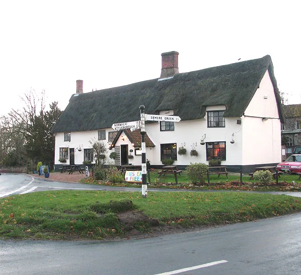
- Amenity
- pub
- Street
- Harleston Road
- Website
- https://thecrowninn-pulham.co.uk/
- Postal Code
- IP21 4TA
- Building Type
- building
Tourist information offices
Bus stops
Places of worship
Roads nearby
Station RoadBoudicca Way, Church Hill Surgery
50 m
The GreenPulham Market, Pulham Market Post Office, The Falcon, adj, The Falcon, opp, Sassa's Bespoke Cakes
50 m
Market PlacePulham Market
100 m
Guildhall LaneQuiet Lane, Pulham Market Circular Walk
100 m
Olive Court150 m
Market Street150 m
Church WalkPulham Market Memorial Hall, Pulhams & Starston Parish Walks
150 m
Fairstead Close150 m
Falcon Road200 m
Bank Street200 m
Chapel Close250 m
Selwyn Gardens350 m
Beck Close350 m
Selwyn Court400 m
Copperfield Court450 m
Tattlepot RoadTattlepot
450 m
Julians Way450 m
Mill Orchard500 m
Harleston RoadSt Mary Magdalene
600 m
Springfield Walk650 m
Mill Close750 m
Norwich RoadSt Mary's Garage
750 m
Jocelyn Close750 m
Poppy's Lane950 m
Barnes' RoadPublic Footpath
950 m
Boudicca's WayLong Distance Path
1,1 km
Dunning's LanePulham Market Circular Walk, Public Footpath
1,1 km
Ivy Lane1,1 km
Goldsmith Way1,2 km
Bond Close1,2 km
Gray's Lane1,3 km
Chestnut Road1,3 km
Tivetshall Road1,3 km
Old Mill Drive1,3 km
Semere Lane1,3 km
Mill Lane1,4 km
Ducks Foot Road1,5 km
Dirty Lane1,6 km
Colegate End RoadPulham Market Circular Walk, Mill Lane, adj, Mill Lane, opp, Pulham Market Methodist Church
1,8 km
Buildings nearby
Pulham Market Telephone Exchange150 m
Pulham Market Bowls Club350 m
Community centres nearby
Pulham Memorial Hall100 m
Convenience stores nearby
Sam's Local Shopper100 m
Guest house nearby
The Old Bakery Bed & Breakfast150 m
Houses nearby
Island Cottage1,7 km
Places of worship nearby
Saint Mary Magdalene50 m
Pubs nearby
The Falcon PH150 m
Razed railways nearby
Waveney Valley Line1,1 km
Streams nearby
Pulham Beck900 m
| Heritage designation | Grade II listed building |
|---|---|
| Located in | Pulham Market |
| Country | United Kingdom |
| Location | Pulham Market |
Public transport map Pulham Market Legend
| Railway | |
| Bus | |
| Tram |
Cycling map Pulham Market Legend
| Cycle path | |
| Cycle lane on road | |
| Cycling on bus lane | |
| Bicycle street | |
| Cyclists allowed | |
| Cyclists allowed, good surface | |
| No cycling | |
| Cobblestones |
| Long-distance cycle route | (depending on scale) | |
| Long-distance cycle route |
Walking map Pulham Market Legend
| Path |
| Long-distance hiking trail | (depending on scale) | |
| Long-distance hiking trail | ||
| No pedestrians |